logo


Marin County Map

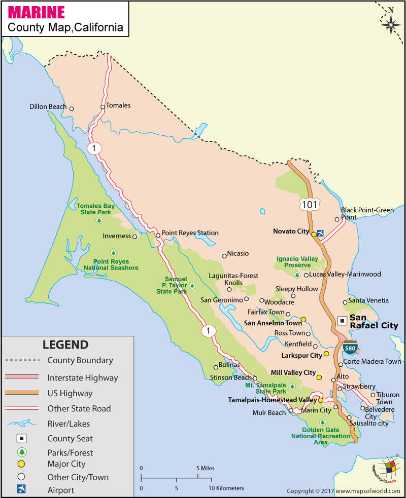
Below is County Map of Marin in California showing the boundaries, roads, highways, towns and much more.

Map of Marin County, California
Marin County Map
Description:Map of Marin county showing the major towns, highways and much more. Disclaimer
×

Disclaimer  :  All efforts have been made to make this image accurate. However MapSherpa, Inc, its directors and employees do not own any responsibility for the correctness or authenticity of the same.


About Marine County, California


Founded as one of the original counties in California, Marine County is located along the Pacific Coast in the San Francisco Bay Area in Northern California. The city of San Rafael is the county seat. Known for its affluence, it is one of the wealthiest counties in the United States. Comprising an area of 828 square miles, it is the fourth smallest county in the Golden State.


Eastern side of the county features a string of communities along the San Francisco Bay, from Sausalito to San Rafael. The interior part is mostly under agricultural use and open spaces. Western Marin County, which is accessed via State Route 1, has smaller, outlying, unincorporated communities relying on agriculture and tourism. The sandy stretches of Bolinas, Dillon, Stinson, Inverness, and McClures are popular surfing and summer destinations in California.

The Marin County Civic Center, designed by Frank Lloyd Wright, draws scores of visitors to take guided tours of its unique design. Among the natural attractions in the county include the Muir Woods redwood forest, Marin Headlands, Point Reyes National Seashore, and Mount Tamalpais – popular spot for hiking and mountain biking. Interstate 580, US 101, SR 1, and SR 37 are major highways in Marin County. San Francisco International Airport (SFO) and Oakland International Airport (OAK) are the nearest airports served by commercial flights.

MOW.DT.01.03.16


Inside the page

Facts about Marin County

County NameMarin County
FoundedFeb 18, 1850
Area828 sq mi (2,140 km2)
Land Area520 sq mi (1,300 km2)
Water Area308 sq mi (800 km2)
Population252,409 (2010)
Largest citySan Rafael (population and area)
County SeatSan Rafael
Time zonePacific Standard Time (UTC-8) Summer (DST) Pacific Daylight Time (UTC-7)


Cities in Marin County

CityCountyPopulation
AltoMarin711
Belvedere cityMarin2,068
Black Point-Green PointMarin1,306
BolinasMarin1,620
Corte Madera townMarin9,253
Dillon BeachMarin283
Fairfax townMarin7,441
InvernessMarin1,304
KentfieldMarin6,485
Lagunitas-Forest KnollsMarin1,819
Larkspur cityMarin11,926
Lucas Valley-MarinwoodMarin6,094
Marin CityMarin2,666
Mill Valley cityMarin13,903
Muir BeachMarin310
NicasioMarin96
Novato cityMarin51,904
Point Reyes StationMarin848
Ross townMarin2,415
San Anselmo townMarin12,336
San GeronimoMarin446
San Rafael cityMarin57,713
Santa VenetiaMarin4,292
Sausalito cityMarin7,061
Sleepy HollowMarin2,384
Stinson BeachMarin632
StrawberryMarin5,393
Tamalpais-Homestead ValleyMarin10,735
Tiburon townMarin8,962
TomalesMarin204
WoodacreMarin1,348


Mountain Peaks in Marin County


Mountain Peak/HillElevation [Meter]
Antonio Mountain355
Bald Hill349
Ballou Point616
Bare Knoll483
Barnabe Mountain436
Black Mountain388
Bon Air Hill59
Bullet Hill18
Burdell Mountain476
Cardiac Hill417
Cherry Hill138
Chicken Coop Hill24
Cliff Peak428
Deer Point282
East Peak783
Firtop399
Green Hill427
Grove Hill127
Hammock Hill278
Hawk Hill214
Hicks Mountain467
Hill 88262
Homestead Hill261
King Mountain235
Knob Hill294
Liberty Peak433
Little Mountain248
Loma Alta486
Middle Peak766
Moore Hill70
Mount Caroline Livermore215
Mount Vision390
Mount Wittenberg429
Novato Heights120
Oat Hill375
Pablo Point284
Pacheco Hill132
Palm Hill52
Pilot Knob344
Pine Mountain537
Point Reyes Hill408
Red Hill86
Red Hill375
Ring Mountain183
Ross Hill202
San Pedro Hill-64
San Rafael Hill201
Serpentine Point474
Shroyer Mountain441
Slacker Hill283
Stewart Point237
Sugarloaf144
Sugarloaf Hill67
Three Peaks340
Trojan Point565
Turtle Back40
Twin Knolls602
West Peak776
West Point531
White Hill436
Wooded Knoll465


Airports in Marin County


Airport Name
Commodore Center Heliport
Commodore Center Seaplane Base
Gnoss Field
San Rafael Airport
San Rafel Private Heliport

Golf Courses in Marin County


Name of Golf CourseLatitudeLongitude
Indian Valley Golf Club-Novato38.120483-122.63573
Marin Country Club-Novato38.065279-122.563857
McInnis Park Golf Center-San Rafael38.02341-122.522551
Meadow Club-Fairfax37.973245-122.619743
Mill Valley Golf Course-Mill Valley37.90957-122.53799
Peacock Gap Golf & Country Club-San Rafael37.995952-122.464486
San Geronimo Golf Club-San Geronimo38.014735-122.658134
StoneTree Golf Club-Novato38.102793-122.509957

National Parks in Marin County


Name of ParkLatitudeLongitude 
Golden Gate NRA37.860508-122.422338
Muir Woods NM37.896848-122.579857
Point Reyes NS38.05346-122.880583


County Maps of California

Alameda County MapMarin County MapSan Luis Obispo County Map
Alpine County MapMariposa County MapSan Mateo County Map
Amador County MapMendocino County MapSanta Barbara County Map
Butte County MapMerced County MapSanta Clara County Map
Calaveras County MapModoc County MapSanta Cruz County Map
Colusa County MapMono County MapShasta County Map
Contra Costa County MapMonterey County MapSierra County Map
Del Norte County MapNapa County MapSiskiyou County Map
El Doredo County MapNevada County MapSolano County Map
Fresno County MapOrange County MapSonoma County Map
Glenn County MapPlacer County MapStanislaus County Map
Humboldt County MapPlumas County MapSutter County Map
Imperial County MapRiverside County MapTehama County Map
Inyo County MapSacramento County MapTrinity County Map
Kern County MapSan Benito County MapTulare County Map
Kings County MapSan Bernardino County MapTuolumne County Map
Lake County MapSan Diego County MapVentura County Map
Lassen County MapSan Francisco County MapYolo County Map
Los Angeles County MapSan Joaquin County MapYuba County Map
Madera County Map 


Map of Cities in California

Long Beach city MapOakland city MapAnaheim city Map
Santa Ana city MapRiverside city MapStockton city Map
Chula Vista city MapFremont city MapIrvine city Map
San Bernardino city MapModesto city MapOxnard city Map
Los Angeles city Map San Francisco city Map Sacramento city Map
San Jose city Map Bakersfield city Map Fullerton city Map


Last Updated Date: September 20th, 2021