logo


Lassen County Map

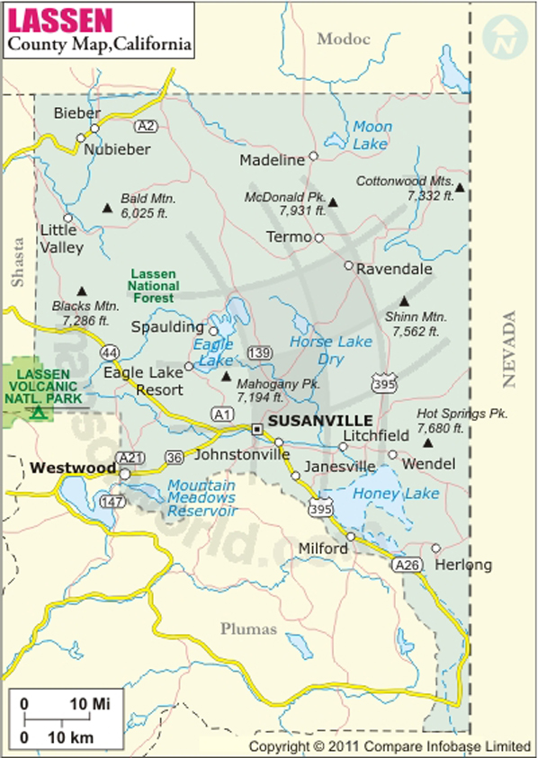
Below is County Map of Lassen in California showing the boundaries, roads, highways, towns and much more.

Map of Lassen County, California
Lassen County Map
Description:Map of Lassen county showing the major towns, highways and much more. Disclaimer
×

Disclaimer  :  All efforts have been made to make this image accurate. However MapSherpa, Inc, its directors and employees do not own any responsibility for the correctness or authenticity of the same.


Inside the page

Facts about Lassen County

County NameLassen County
Founded1864
Area4,720 sq mi (12,200 km2)
Land Area4,541 sq mi (11,760 km2)
Water Area179 sq mi (460 km2)
Population34,895 (2010)
CitiesSusanville
County SeatSusanville
Time zonePacific Standard Time (UTC-8)Summer (DST) Pacific Daylight Time (UTC-7)

About Lassen County in California


Incorporated in 1864, Lassen County is located along the California–Nevada state line in Northern California. The seat and the only incorporated city of the county is Susanville. The county extends over a total area of 4,720 square miles.

The Warner Mountains cover the northeastern corner of Lassen County, while part of Lassen Volcanic National Park extends into western Lassen county. The national park features steaming sulfur holes, meadows covers with wildflowers, clear alpine lakes, and numerous volcanoes. The 3,187-meter-tall Lassen Peak in the Shasta Cascade region is the centerpiece of the entire wilderness of the park.

Recreational activities around Honey Lake, near the Nevada border, include birdwatching, picnicking, hiking, camping, fishing, and waterfowl hunting. Campgrounds in Eagle Lake Recreation Area and Susanville Ranch Park are popular spots to spend a relaxing vacation during the summer. Susanville, a former logging and mining town, is home to two state prisons: the California Correctional Center and the High Desert State Prison, California. Susanville lies at the intersection of State Routes 36 and 139. US Route 395 traverses the county from north to south.

MOW.DT.01.14.17


Cities in Lassen County


CityPopulation
Bieber312
Clear Creek169
Doyle678
Herlong298
Janesville1,408
Johnstonville1,024
Litchfield195
Milford167
Patton Village702
Spaulding178
Susanville city17,947
Westwood1,647


Mountain Peaks in Lassen County


Mountain Peak/HillElevation [Meter]
Adams Peak2,494
Anderson Mountain2,053
Antelope Mountain1,772
Antelope Mountain2,326
Ash Butte2,306
Ashurst Mountain2,143
Bald Hill2,101
Bald Mountain1,588
Bald Mountain1,850
Bass Hill1,495
Bennett Knoll1,848
Black Butte2,435
Black Cone2,467
Black Mountain2,185
Black Mountain1,919
Black Mountain1,843
Blacks Mountain2,222
Bogard Buttes2,282
Bosco Hill1,664
Boyd Hill1,807
Brisco Butte1,504
Buck Mountain2,625
Button Mountain1,999
Cal Mountain1,967
Campbell Mountain2,052
Caribou Peak2,104
Cave Mountain1,916
Chaparral Hill1,979
Cherry Mountain1,854
China Knoll1,322
Cinder Cone2,041
Clover Butte1,882
Cochran Hill1,801
Cold Spring Mountain2,129
Cone Mountain2,024
Cottonwood Peak1,992
Coyote Peak2,321
Crater Mountain2,197
Crystal Peak2,375
Diamond Mountain2,334
Dill Butte1,746
Dixie Peak1,850
Dixon Hill1,426
Dorsey Butte1,747
Dow Butte1,972
Dyer Mountain2,273
First Butte1,382
Five Springs Mountain1,820
Fort Mountain1,813
Fourth Butte1,440
Fox Mountain2,161
Fredonger Butte1,966
Fredonyer Peak2,374
Gallatin Peak2,112
Goat Mountain1,760
Gooch Mountain1,975
Goodrich Mountain1,866
Greens Peak2,171
Griffith Hill1,995
Hamilton Mountain2,237
Hartson Sand Ridge1,219
Harvey Mountain2,217
Haskell Peak2,165
Hat Mountain2,657
Hayden Hill1,924
Heavey Mountain1,988
Horse Lake Mountain1,958
Hot Springs Peak2,317
Indian Mountain1,698
Indicator Peak2,283
Jim Peterson Hill1,345
Keddie Peak1,967
Knox Mountain2,149
Ladder Butte1,731
Lava Peak1,990
Letterbox Hill1,755
Likely Mountain2,249
Little Bald Mountain1,795
Little Baldy Mountain1,766
Little Dyer Mountain1,939
Little Fredonyer1,783
Little Fredonyer1,781
Little Gold Hill1,364
Little Harvey Mountain1,816
Little Haskell Peak1,870
Little Hat Mountain2,363
Logan Mountain2,121
Long Hill1,839
Lonkey Hill1,528
Lost Valley Mountain1,752
Lower Signal Butte1,782
Mahogany Mountain2,084
Mahogany Peak2,175
Manzanita Hill1,804
McDonald Peak2,398
McKesick Peak2,158
Meadow View Peak2,105
Merrill Mountain1,770
Mitchell Hill1,879
Mount Hoffman2,381
Negro Camp Mountain1,728
Negro Mountain1,694
North Caribou2,373
Observation Peak2,417
Olson Mountain2,072
Patterson Mountain2,097
Pegleg Mountain2,164
Poison Butte1,844
Red Cinder2,549
Red Cinder Cone2,550
Red Rock Mountain2,593
Ricketts Hill1,385
Roop Mountain2,319
Round Mountain1,579
Round Valley Butte2,008
Rush Creek Mountain1,894
Second Butte1,414
Shaffer Mountain2,029
Sheephead Mountain1,944
Shinn Mountain2,297
Shinn Peaks2,158
Shugru Hill1,348
Signal Butte1,916
Slate Mountain2,162
Snag Hill1,846
Snowstorm Mountain1,978
South Caribou2,363
South Knob2,073
Spanish Springs Peak2,309
Spring Hill1,955
Sugarloaf1,881
Summers Hill1,810
Sunrise Peak2,135
Susanville Peak1,986
Taylor Knob1,192
Termo Buttes1,623
The Buttes1,478
Third Butte1,401
Three Peaks2,107
Tule Mountain2,160
Tule Mountain2,144
Tunnison Mountain1,760
Turtle Mountain1,457
Twin Buttes1,764
Whaleback Mountain2,041
Whitinger Mountain2,143
Widow Mountain1,928


Airports in Lassen County


Airport Name
Adin Airport
Amedee Army Air Field
Herlong Airport
Lassen Community Hospital Heliport
Ravendale Airport
Southard Field
Spaulding Airport
Susanville Municipal Airport
Wcdh Heliport

Golf Courses in Lassen County


Name of Golf CourseLatitudeLongitude
Diamond Mountain Golf Club-Susanville40.364557-120.652497

National Parks in Lassen County


Name of ParkLatitudeLongitude 
Lassen Volcanic NP40.494117-121.40578

County Maps of California

Alameda County MapMarin County MapSan Luis Obispo County Map
Alpine County MapMariposa County MapSan Mateo County Map
Amador County MapMendocino County MapSanta Barbara County Map
Butte County MapMerced County MapSanta Clara County Map
Calaveras County MapModoc County MapSanta Cruz County Map
Colusa County MapMono County MapShasta County Map
Contra Costa County MapMonterey County MapSierra County Map
Del Norte County MapNapa County MapSiskiyou County Map
El Doredo County MapNevada County MapSolano County Map
Fresno County MapOrange County MapSonoma County Map
Glenn County MapPlacer County MapStanislaus County Map
Humboldt County MapPlumas County MapSutter County Map
Imperial County MapRiverside County MapTehama County Map
Inyo County MapSacramento County MapTrinity County Map
Kern County MapSan Benito County MapTulare County Map
Kings County MapSan Bernardino County MapTuolumne County Map
Lake County MapSan Diego County MapVentura County Map
Lassen County MapSan Francisco County MapYolo County Map
Los Angeles County MapSan Joaquin County MapYuba County Map
Madera County Map 


Map of Cities in California

Long Beach city MapOakland city MapAnaheim city Map
Santa Ana city MapRiverside city MapStockton city Map
Chula Vista city MapFremont city MapIrvine city Map
San Bernardino city MapModesto city MapOxnard city Map
Los Angeles city Map San Francisco city Map Sacramento city Map
San Jose city Map Bakersfield city Map Fullerton city Map


Last Updated Date: September 20th, 2021