logo


Kings County Map

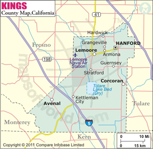
Below is County Map of Kings in California showing the boundaries, roads, highways, towns and much more.

Map of Kings County, California
Kings County Map
Description:Map of Kings county showing the major towns, highways and much more. Disclaimer
×

Disclaimer  :  All efforts have been made to make this image accurate. However MapSherpa, Inc, its directors and employees do not own any responsibility for the correctness or authenticity of the same.


Inside the page

Facts about Kings County

County NameKings County
Founded1893
Area1,392 sq mi (3,610 km2)
Land Area1,389 sq mi (3,600 km2)
Water Area2.1 sq mi (5 km2)
Population150,181 (2014)
Largest cityHanford (population) Avenal (area)
CitiesHanford, Lemoore, Corcoran, Avenal
County SeatHanford
Time zonePacific Standard Time (UTC-8) Summer (DST) Pacific Daylight Time (UTC-7)

Cities in Kings County


CityPopulation
Armona4,156
Avenal city15,505
Corcoran city24,813
Grangeville469
Hanford city53,967
Hardwick138
Home Garden1,761
Kettleman City1,439
Lemoore city24,531
Lemoore Station7,438
Stratford1,277

Mountain Peaks in Kings County


Mountain Peak/HillElevation [Meter]
Badger Hill140
Block Hill272
Boulder Hill146
Broken Hill214
Cerro Alto382
Cerro Lodoso393
Cerro Ultimo345
Dombo338
El Bulto305
El Chichon387
El Collado248
El Dombo334
El Le¾n398
El Lobo371
El Loro374
El Mirador277
El Perno259
El Perro368
El Piso376
El Pßjaro327
El Pulgar382
El Rabo130
El Rascador314
El Taco295
El Tolete369
Flattop658
Garza Peak797
Hydril Hill330
Johnson Peak784
La Cima418
La Clavija325
La Cuba217
La Cuesta369
La Cumbre404
La Lomica158
La Meseta371
La Morra285
La Oveja325
La Palomera320
Mesa Roida306
Mustang Hill213
Oyster Hill146
Parejo Hill161
Pipe Hill233
Ragged Top581
Roundtop775
Tar Peak737
Three Peaks784
Zwang Peak939


Airports in Kings County


Airport Name
Avenal Airport
Blair Strip
Corcoran Airport
El Rico Airport
Hanford Community Medical Center Helistop
Hanford Municipal Airport
Jones Farms Airport
Kings County Houston Ave. Heliport
Lemoore Naval Air Station (Reeves Field) Airport
Machado Dusters Airport
Newton Field
Salyer Farms Airport
Stone Airstrip
Stone Land County Airport
Swanson Ranch Nr 1 Airport
Vineyard Oaks Farm Airport
Westlake Farms Airport

Golf Courses in Kings County


Name of Golf CourseLatitudeLongitude
Kings Country Club-Hanford36.419558-119.672591
Lakeview Golf Course-Hanford36.313335-119.617293
Lemoore Municipal Golf Course-Lemoore36.283826-119.785239


Map of Cities in California

Long Beach city MapOakland city MapAnaheim city Map
Santa Ana city MapRiverside city MapStockton city Map
Chula Vista city MapFremont city MapIrvine city Map
San Bernardino city MapModesto city MapOxnard city Map
Los Angeles city Map San Francisco city Map Sacramento city Map
San Jose city Map Bakersfield city Map Fullerton city Map


Last Updated Date: October 27th, 2016