logo


Kern County Map

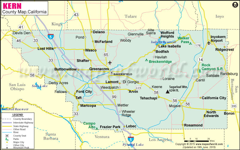
Below is County Map of Kern in California showing the boundaries, roads, highways, towns and much more.

Map of Kern County, California

Kern County Map Tulare Inyo San Bernardino Los Angeles Ventura Santa Barbara San Luis Obispo Kings Fresno Monterey
Description:Map of Kern county showing the major towns, highways and much more. Disclaimer
×

Disclaimer  :  All efforts have been made to make this image accurate. However MapSherpa, Inc, its directors and employees do not own any responsibility for the correctness or authenticity of the same.


Kern County in California


Founded in 1866, Kern County is located in Southern California. With an area of 8,163 square miles, it is the third largest county in California by area. The county is known for oil industry and rich agricultural produce. Kern County lies in the southern end of the Central Valley. The county features three notable physical regions: the Sierra Nevada range in the east, the San Joaquin Valley in the west, the Tehachapi Mountains in the south. Bakersfield is the county seat.

From private ski ranches to shooting ranges, the county offers a range of delights. Famous for scenic desert cliffs, Red Rock Canyon State Park is popular for hiking, camping, climbing, and horseback riding. Lake Ming is often used for recreation purposes like water-skiing, boating, and fishing.


The Bakersfield Museum of Art showcases works of Californian artists, the Kern County Museum exhibits historical artifacts and focuses on the region's Native American and oil history. In addition to this, the region is famous for Bakersfield Sound, a honky-tonk genre of country music. Fort Tejon State Historic Park, Minter Field Air Museum, Camelot Park, California Living Museum, and Beach Park are other notable attractions in the county.


How to Reach Kern County

Meadows Field (BFL) in Bakersfield is county's primary airport.

Amtrak's San Joaquin regional route serves the station in Bakersfield.

Westside Freeway, Golden State Freeway, and Paso Robles Highway are major roads in the county.

Inside the page

Facts about Kern County

County NameKern County
Founded1866
Area8,163 sq mi (21,140 km2)
Land Area8,132 sq mi (21,060 km2)
Water Area31 sq mi (80 km2)
Population839,631 (2010)
Largest cityBakersfield
County SeatBakersfield
Time zonePacific Standard Time (UTC-8) Summer (DST) Pacific Daylight Time (UTC-7)

Cities in Kern County


CityPopulation
Arvin city19,304
Bear Valley Springs5,172
Bodfish1,956
Boron2,253
Buttonwillow1,508
California city14,120
China Lake Acres1,876
Delano city53,041
Edwards AFB2,063
Ford City4,278
Frazier Park2,691
Golden Hills8,656
Greenacres5,566
Greenfield3,991
Inyokern1,099
Kernville1,395
Lake Isabella3,466
Lamont15,120
Lebec1,468
Lost Hills2,412
Maricopa city1,154
McFarland city12,707
Mojave4,238
North Edwards1,058
Oildale32,684
Pine Mountain Club2,315
Ridgecrest city27,616
Rosamond18,150
Rosedale14,058
Shafter city16,988
South Taft2,169
Stallion Springs2,488
Taft city9,327
Taft Heights1,949
Tehachapi city14,414
Wasco city25,545
Weedpatch2,658
Weldon2,642
Wofford Heights2,200


Mountain Peaks in Kern County


Mountain Peak/HillElevation [Meter]
Ant Hill295
Antimony Peak2,076
Antimony Peak1,412
Bald Eagle Peak1,882
Ball Mountain1,404
Ball Mountain1,247
Basket Peak1,858
Bear Mountain2,106
Black Bill Peak1,538
Black Mountain1,731
Black Mountain1,589
Black Mountain2,256
Blue Point864
Bodfish Peak1,829
Bohna Peak2,044
Breckenridge Mountain2,289
Brown Butte885
Brown Peak2,461
Brush Mountain2,149
Brushy Hill371
Burke Hill1,206
Butterbredt Peak1,819
Cache Peak2,035
Cane Peak1,382
Cascajo Hill179
Castle Butte949
Cerro del Sur146
Cerro Noroeste2,525
Chuckwalla Mountain1,536
Cook Peak1,575
Cooks Peak2,105
Covington Mountain2,361
Cross Mountain1,585
Cummings Mountain2,362
De Stazo Hill905
Desert Butte808
Doney Hill866
Double Mountain2,430
Eagle Peak1,670
Eagle Rest Peak1,834
Eagles Nest1,201
El Paso Peaks1,382
El Vej¾n165
Emerald Mountain1,515
Emigrant Hill226
Escapula Peak2,160
Fiss Hill795
Five Fingers1,542
Fulton Peak1,454
Galileo Hill1,006
Gem Hill917
Goat Peak1,608
Gold Peak1,806
Gould Hill433
Government Peak1,419
Grapevine Peak1,466
Grouse Mountain2,613
Harper Peak1,767
Heald Peak2,079
Hillcrest Point469
Hole in the Mountain1,743
Hooper Hill1,354
Horsethief Mountain963
Indian Rocks344
Inspiration Point2,385
Iron Mountain745
Isham Hill668
Jackrabbit Hill878
Johns Peak1,492
Kelso Peak1,539
Knob Hill329
Laura Peak1,586
Laurel Mountain1,344
Mountain Peak/HillElevation [Meter]
Liebel Peak2,441
Liebre Twins1,943
Lightner Peak1,943
Lookout Hill831
Mayan Peak1,844
McKittrick Summit1,317
Middle Knob1,891
Morris Peak2,199
Mound897
Mount Adelaide1,040
Mount Jenkins2,396
Mount Pheasant1,103
Mount Poso369
Mount Vernon198
Nellies Nipple1,390
Nicolls Peak1,844
O'Brien Hill1,391
Oiler Peak1,315
Onyx Peak1,594
Orchard Peak953
Owens Peak2,574
Pajuela Peak1,728
Pampa Peak955
Pilot Knob1,877
Pine Mountain1,184
Pinyon Mountain1,859
Pinyon Peak2,063
Piute Peak2,562
Powers Peak1,759
Quartz Mountain1,585
Rankin Peak1,298
Red Buttes949
Red Hill828
Red Hill541
Red Hill1,307
Red Mountain1,743
Red Mountain1,770
Robbers Roost1,220
Rock Pile196
Rocky Point871
Rough and Ready Mountain1,728
Round Mountain481
Round Mountain903
San Emigdio Mountain2,283
Sanborn Hill869
Saturday Peak1,260
Shirley Peak2,160
Sidney Peak1,309
Skinner Peak2,156
Soledad Mountain1,262
Sorrell Peak2,328
Split Mountain2,039
Standard Hill952
Stevenson Peak1,527
Sugarloaf1,260
Sugarloaf Mountain1,893
Sunday Peak2,501
Sunset Point2,099
Tecuya Mountain2,180
Tehachapi Mountain2,418
Toms Hill1,536
Tropico Hill882
Twentyfive Hill516
Twin Buttes825
Wagon Wheel Mountain198
Weldon Peak1,928
White Mountain1,075
White Rock1,063
Willow Springs Butte998
Windmill Tree Peak1,393
Woodward Peak1,979
Wyleys Knob1,941
Yeguas Mountain848


Airports in Kern County


Airport Name
7R Ranch Airport
Abc7-Tv Heliport
Bakersfield Municipal Airport
Belridge Strip
Blackwell Land Company Inc Airport
Borax Heliport
Burroughs Heliport
California City Municipal Airport
Cashen Airport
China Lake Naws (Armitage Field) Airport
Costerisan Farms Airport
Creekside Airport
Delano Municipal Airport
Di Giorgio Ranch Landing Strip
Edwards Af Aux North Base Airport
Edwards Air Force Base
Elk Hills Buttonwillow Airport
Flying S Ranch Airport
Gilbreath Bros Duck Club Airport
Inyokern Airport
J&J Crop Dusters Inc Airport
Joe Gottlieb Field
Kelso Valley Airport
Kern Medical Center Heliport
Airport Name
Kern Valley Airport
Lloyd's Landing Airport
Lost Hills Kern County Airport
Majors Airport
Meadows Field
Memorial Hospital Heliport
Mojave Airport
Mountain Valley Airport
Paradise Lakes Airport
Paramount Farms Airport
Pontious Airport
Poso Kern County Airport
Psk Ranch Airport
Ridgecrest Community Hospital Heliport
Rosamond Skypark Airport
San Joaquin Community Hospital Heliport
Sce Ridgecrest Service Center Heliport
Shafter Minter Field
Skyotee Ranch Airport
Taft Kern County Airport
Tehachapi Municipal Airport
Tejon Agricultural Airport
Wasco Kern County Airport
West Side Hospital Heliport


Golf Courses in Kern County


Name of Golf CourseLatitudeLongitude
Bakersfield Country Club-Bakersfield35.391281-118.938661
Buena Vista Golf Course-Taft35.231895-119.37013
California City Municipal Par 3 Golf Course-California City35.125791-117.945159
China Lake Golf Course-Ridgecrest35.657144-117.641771
Delano Public Golf Course-Delano35.756874-119.240593
Horse Thief Golf & Country Club-Tehachapi35.08859-118.649819
Kern River Golf Course-Bakersfield35.520541-119.115361
Kern Valley Golf & Country Club-Kernville35.758688-118.388738
Muroc Lake Golf Course-Edwards Afb34.913959-117.938076
North Kern Golf Course Inc-Bakersfield35.520382-119.116067
Oak Tree Country Club-Tehachapi35.168109-118.654878
Pine Mountain Club-Pine Mountain Club34.81913-118.941799
Rio Bravo Country Club-Bakersfield35.402767-118.835059
Seven Oaks Country Club-Bakersfield35.335778-119.122896
Stockdale Country Club-Bakersfield35.354135-119.080395
Sundale Country Club-Bakersfield35.344018-119.070251
Sycamore Canyon Golf Course-Arvin35.16579-118.81445
The Links At Riverlakes Ranch-Bakersfield35.407349-119.101102
Tierra Del Sol Golf Course-California City35.133101-117.944613
Valley Rose Golf Course-Wasco35.603353-119.384918


Map of Cities in California

Long Beach city MapOakland city MapAnaheim city Map
Santa Ana city MapRiverside city MapStockton city Map
Chula Vista city MapFremont city MapIrvine city Map
San Bernardino city MapModesto city MapOxnard city Map
Los Angeles city Map San Francisco city Map Sacramento city Map
San Jose city Map Bakersfield city Map Fullerton city Map


Last Updated Date: September 20th, 2021