logo


Imperial County California Map

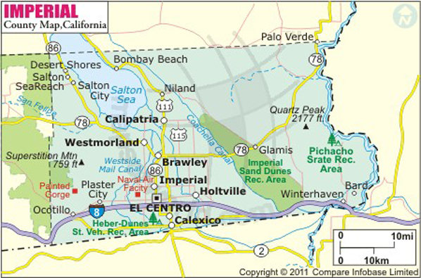
Below is County Map of Imperial in California showing the boundaries, roads, highways, towns and much more.

Map of Imperial County, California
Imperial County Map
Description:Map of Imperial county showing the major towns, highways, railroad and mountain peak. Disclaimer
×

Disclaimer  :  All efforts have been made to make this image accurate. However MapSherpa, Inc, its directors and employees do not own any responsibility for the correctness or authenticity of the same.


Inside the page

Facts about Imperial County

County NameImperial County
FoundedAug 7, 1907
Area4,482 sq mi (11,610 km2)
Land Area4,177 sq mi (10,820 km2)
Water Area305 sq mi (790 km2)
Population174,528 (2010)
Largest cityEl Centro
County SeatEl Centro
Time zonePacific Standard Time (UTC-8) Summer (DST) Pacific Daylight Time (UTC-7)

Imperial County is located in the Imperial Valley in the far southeastern region of California. The county borders Mexico to its south. Founded on August 7, 1907, it is the newest county in California. The county seat and largest city is El Centro. The Colorado River defines the eastern boundary of the county and the California–Nevada state line.

Besides its rich agricultural heritage, the county features plenty of attractions to explore. The remnants of Fort Yuma preserves the local Native American culture. The Algodones Dunes of the Sonoran Desert is a preferred terrain for off-road enthusiasts. The Sonny Bono Salton Sea National Wildlife Refuge is a renowned breeding ground and thus, its trails are popular among birders and wildlife lovers. Salvation Mountain, Desert View Tower, Museum of History in Granite, Imperial Valley Desert Museum, and Quechan Casino Resort are famous attractions in Imperial County.


Brawley, Calexico, Calipatria, El Centro, Holtville, Imperial, and Westmorland are major cities in Imperial County. Interstate 8 is the primary east-west corridor in the county. State Route 111 and SR 78 are secondary highways passing through a few populated areas. The nearest Amtrak station is in Yuma (Arizona state), which is served by the Sunset Limited route.

MOW.DT.01.18.17


Inside the page

Facts about Imperial County

County NameImperial County
FoundedAug 7, 1907
Area4,482 sq mi (11,610 km2)
Land Area4,177 sq mi (10,820 km2)
Water Area305 sq mi (790 km2)
Population174,528 (2010)
Largest cityEl Centro
County SeatEl Centro
Time zonePacific Standard Time (UTC-8) Summer (DST) Pacific Daylight Time (UTC-7)

Cities in Imperial County


CityPopulation
Bombay Beach295
Brawley city24,953
Calexico city38,572
Calipatria city7,705
Desert Shores1,104
El Centro city42,598
Heber4,275
Holtville city5,939
Imperial city14,758
Niland1,006
Salton City3,763
Salton Sea Beach422
Seeley1,739
Westmorland city2,225
Winterhaven394


Mountain Peaks in Imperial County


Mountain Peak/HillElevation [Meter]
Algodones Dunes101
Black Mountain646
Blue Angels Peak1,374
Blue Mountain539
Buzzards Peak367
Carrizo Mountain734
Clay Point29
Deer Peak34
East Mesa27
Flat Tops449
Lion Head Mountain344
Little Picacho Peak266
Mount Barrow659
Obsidian Butte-53
Palo Verde Peak500
Pasadena Mountain438
Pasadena Peak468
Pebble Mountain307
Peter Kane Mountain627
Picacho Peak397
Pilot Knob252
Pilot Knob Mesa209
Quartz Peak648
Red Hill-43
Red Island-60
Rock Hill-55
Rojo Grande202
Sawtooth Mountain439
Stud Mountain612
Sugarloaf Mountain298
Sunrise Butte116
Superstition Mountain220
Thumb Peak317
Travertine Rock17


Airports in Imperial County


Airport Name
Brawley Municipal Airport
Calexico International Airport
Cliff Hatfield Memorial Airport
Douthitt Strip
El Centro Naf Airport
El Centro Regional Medical Center Heliport
Emory Ranch Airport
Holtville Airport
Imperial County Airport
Johnson Brothers Airport
O'Connell Brothers Airport
Pioneers Memorial Hospital Heliport
Salton Sea Airport
Walter'S Camp Airport

Golf Courses in Imperial County


Name of Golf CourseLatitudeLongitude
Barbara Worth Resort-Holtville32.800604-115.421775
Del Rio Country Club-Brawley33.003307-115.526475
Desert Trails Golf Course and Resort-El Centro32.77102-115.546965
Rio Bend Golf Course-El Centro32.76608-115.690479


County Maps of California

Alameda County MapMarin County MapSan Luis Obispo County Map
Alpine County MapMariposa County MapSan Mateo County Map
Amador County MapMendocino County MapSanta Barbara County Map
Butte County MapMerced County MapSanta Clara County Map
Calaveras County MapModoc County MapSanta Cruz County Map
Colusa County MapMono County MapShasta County Map
Contra Costa County MapMonterey County MapSierra County Map
Del Norte County MapNapa County MapSiskiyou County Map
El Doredo County MapNevada County MapSolano County Map
Fresno County MapOrange County MapSonoma County Map
Glenn County MapPlacer County MapStanislaus County Map
Humboldt County MapPlumas County MapSutter County Map
Imperial County MapRiverside County MapTehama County Map
Inyo County MapSacramento County MapTrinity County Map
Kern County MapSan Benito County MapTulare County Map
Kings County MapSan Bernardino County MapTuolumne County Map
Lake County MapSan Diego County MapVentura County Map
Lassen County MapSan Francisco County MapYolo County Map
Los Angeles County MapSan Joaquin County MapYuba County Map
Madera County Map 


Map of Cities in California

Long Beach city MapOakland city MapAnaheim city Map
Santa Ana city MapRiverside city MapStockton city Map
Chula Vista city MapFremont city MapIrvine city Map
San Bernardino city MapModesto city MapOxnard city Map
Los Angeles city Map San Francisco city Map Sacramento city Map
San Jose city Map Bakersfield city Map Fullerton city Map


Last Updated Date: September 20th, 2021