logo


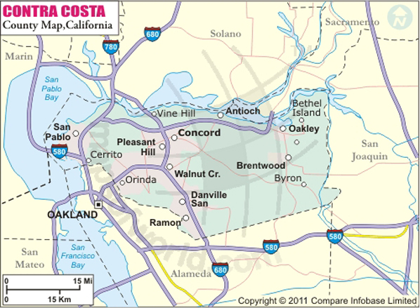
Contra Costa County Map

Below is County Map of Contra Costa in California showing the boundaries, roads, highways, towns and much more.

Map of Contra Costa County, California

Contra Costa County Map
Description:Map of Contra county showing the major towns, highways and much more. Disclaimer
×

Disclaimer  :  All efforts have been made to make this image accurate. However MapSherpa, Inc, its directors and employees do not own any responsibility for the correctness or authenticity of the same.


About Contra Costa County, California


Contra Costa County is located in the northern portion of the East Bay region in Northern California. Its name means "opposite the coast" in Spanish. Largely suburban in character, the county lies in the San Francisco–Oakland–Hayward, CA Metropolitan Statistical Area. The county seat is Martinez and the most populous city is Concord, which is primarily a bedroom community.

The county covers an area of 804 square miles. The upthrust peak of 1,173-meter Mount Diablo, the most visible natural landmark in the East Bay Area. The mountain is the centerpiece of Mt. Diablo State Park. Camping facilities and multi-purpose trails are available for visitors in the park. Antioch Dunes National Wildlife Refuge, Don Francisco Galindo House, Don Francisco Galindo House, and San Pablo Reservoir are prominent points of interest in Contra Costa County.


Downtown Martinez is lined with historical buildings and antique shops. Amtrak daily runs California Zephyr and Coast Starlight trains through Martinez, while cities of Richmond, Martinez, and Antioch lie along Amtrak's San Joaquins route. The city of Concord is served by Interstate 680 and California State Route 4 – a major east-west corridor in Contra Costa County. Nearest commercial airports are in Oakland and San Francisco. Bay Area Rapid Transit (BART) provides local transportation in the region.

MOW.DT.01.14.17


Inside the page

Facts about Contra Costa County

County NameContra Costa County
FoundedFeb 18, 1850
Area804 sq mi (2,080 km2)
Land Area716 sq mi (1,850 km2)
Water Area88 sq mi (230 km2)
Population1,049,025 (2010)
Largest cityConcord (population and area)
County SeatMartinez
Time zonePacific Standard Time (UTC-8)Summer (DST) Pacific Daylight Time (UTC-7)

Cities in Contra Costa County


CityPopulationLatitudeLongitude
Acalanes Ridge 113737.904722-122.078574
Alamo 1457037.854599-122.012993
Alhambra Valley 92437.968658-122.136326
Antioch city10237237.977704-121.796607
Bay Point 2134938.032846-121.961328
Bayview 175438.005694-122.320635
Bethel Island 213738.029003-121.640567
Blackhawk 935437.81598-121.907142
Brentwood city5148137.935485-121.718872
Byron 127737.875518-121.641829
Camino Tassajara 219737.790966-121.884979
Castle Hill 129937.872963-122.057334
Clayton city1089737.940298-121.930105
Clyde 67838.025106-122.027966
Concord city12206737.972181-122.001588
Contra Costa Centre 536437.926013-122.054019
Crockett 309438.051939-122.220152
Danville town4203937.81219-121.969961
Diablo 115837.840809-121.956456
Discovery Bay 1335237.906428-121.598491
East Richmond Heights 328037.945081-122.313907
El Cerrito city2354937.919639-122.302392
El Sobrante 1266937.972261-122.295886
Hercules city2406038.033512-122.294667
Kensington 507737.908367-122.280591
Knightsen 156837.963246-121.651086
Lafayette city2389337.891699-122.119
Martinez city3582437.999554-122.115105
Montalvin Manor 287637.997664-122.329652
Moraga town1601637.843826-122.123088
Mountain View 237238.009241-122.116858
Norris Canyon 95737.746035-121.988785
North Gate 67937.906153-121.998184
North Richmond 371737.964585-122.372808
Oakley city3543237.992972-121.695085
Orinda city1764337.880875-122.179333
Pacheco 368537.98786-122.069906
Pinole city1839038.013912-122.322694
Pittsburg city6326438.018974-121.897072
Pleasant Hill city3315237.954019-122.075881
Port Costa 19038.044542-122.184944
Reliez Valley 310137.93992-122.102696
Richmond city10370137.951737-122.360159
Rodeo 867938.037728-122.254108
Rollingwood 296937.965444-122.33058
San Miguel 339237.8867-122.036831
San Pablo city2913937.962725-122.342456
San Ramon city7214837.762371-121.93815
Saranap 520237.887816-122.076127
Shell Ridge 95937.90592-122.034394
Tara Hills 512637.993723-122.318785
Vine Hill 376138.007105-122.087288
Walnut Creek city6417337.902418-122.039889


Mountain Peaks in Contra Costa County


Mountain Peak/HillElevation [Meter]
Artist Point485
Black Point492
Boon Hill195
Bush Hill208
Castle Hill210
Cave Point636
Chaparral Peak538
Eagle Peak698
Eureka Peak496
Harlan Hill529
Knob Point568
Las Trampas Peak551
Lawson Hill338
Mitchell Rock436
Mount Diablo1171
Mount Helen201
Mount Wanda196
Mount Zion472
Mulholland Hill358
Mulligan Hill426
Nickols Knob113
Nob Hill44
North Peak1064
Oyster Point644
Ransom Point1037
Redwood Peak469
Round Top531
Sugarloaf Hill148
Twin Peaks463
Vollmer Peak581
Wall Point473
Wiedemann Hill563
William Rust Summit306
Windy Point633

Airports in Contra Costa County


Airport Name
Brookside Hospital Heliport
Buchanan Field
Byron Airport
Funny Farm Airport
John Muir Walnut Creek Medical Center Heliport
Las Serpientes Airport
Little Hands STOLport
Q Area Heliport
Sandhill Heliport
U of C - Richmond Field Station Heliport


Golf Courses in Contra Costa County


Name of Golf CourseLatitudeLongitude
Blackhawk Country Club-Danville37.818743-121.916028
Boundary Oak Golf Course-Walnut Creek37.923714-121.996716
Brentwood Golf Club-Brentwood37.924386-121.728257
Buchanan Fields Golf Course-Concord37.979131-122.059244
Canyon Lakes Country Club-San Ramon37.771052-121.947678
Contra Costa Country Club-Pleasant Hill37.973847-122.080823
Crow Canyon Country Club-Danville37.785145-121.962121
Deer Ridge Country Club-Brentwood37.914681-121.738315
Diablo Country Club-Diablo37.836663-121.958615
Diablo Creek Golf Course-Concord38.012363-122.023703
Diablo Hills Golf Course-Walnut Creek37.917401-122.043314
Discovery Bay Country Club-Discovery Bay37.894197-121.593697
Franklin Canyon Golf Course-Hercules38.006951-122.215913
Grayson Woods Golf Course-Pleasant Hill37.948405-122.09755
Lone Tree Golf Course-Antioch37.974657-121.80365
Mira Vista Country Club-El Cerrito37.932908-122.302169
Moraga Country Club-Moraga37.835816-122.136565
Oakhurst Country Club-Clayton37.939831-121.926638
Orinda Country Club-Orinda37.891511-122.190531
Pine Meadows Public Golf Course-Martinez37.987433-122.096906
Pittsburg's Delta View Golf Course-Pittsburg38.013373-121.910771
Richmond Country Club-Richmond37.984567-122.350563
Rossmoor Golf Course-Walnut Creek37.863938-122.067387
Round Hill Country Club-Alamo37.854715-122.008816
San Ramon Golf Club-San Ramon37.733078-121.928079
Shadow Lakes Golf Club-Brentwood37.925916-121.752318
The Bethel Island Golf Club-Bethel Island38.01967-121.635312
The Bridges Golf Club At Gale Ranch-San Ramon37.771934-121.931588
The Golf Club at Roddy Ranch-Antioch37.924212-121.788228
Tilden Park Golf Course-Berkeley37.887551-122.245504

National Parks in Contra Costa County


Name of ParkLatitudeLongitude
Eugene O Neill NHS37.825979-122.026594
John Muir NHS37.99125-122.131087
John Muir NHS37.982695-122.132935
John Muir NHS37.978972-122.124367


County Maps of California

Alameda County MapMarin County MapSan Luis Obispo County Map
Alpine County MapMariposa County MapSan Mateo County Map
Amador County MapMendocino County MapSanta Barbara County Map
Butte County MapMerced County MapSanta Clara County Map
Calaveras County MapModoc County MapSanta Cruz County Map
Colusa County MapMono County MapShasta County Map
Contra Costa County MapMonterey County MapSierra County Map
Del Norte County MapNapa County MapSiskiyou County Map
El Doredo County MapNevada County MapSolano County Map
Fresno County MapOrange County MapSonoma County Map
Glenn County MapPlacer County MapStanislaus County Map
Humboldt County MapPlumas County MapSutter County Map
Imperial County MapRiverside County MapTehama County Map
Inyo County MapSacramento County MapTrinity County Map
Kern County MapSan Benito County MapTulare County Map
Kings County MapSan Bernardino County MapTuolumne County Map
Lake County MapSan Diego County MapVentura County Map
Lassen County MapSan Francisco County MapYolo County Map
Los Angeles County MapSan Joaquin County MapYuba County Map
Madera County Map 


Map of Cities in California

Long Beach city MapOakland city MapAnaheim city Map
Santa Ana city MapRiverside city MapStockton city Map
Chula Vista city MapFremont city MapIrvine city Map
San Bernardino city MapModesto city MapOxnard city Map
Los Angeles city Map San Francisco city Map Sacramento city Map
San Jose city Map Bakersfield city Map Fullerton city Map


Last Updated Date: September 20th, 2021