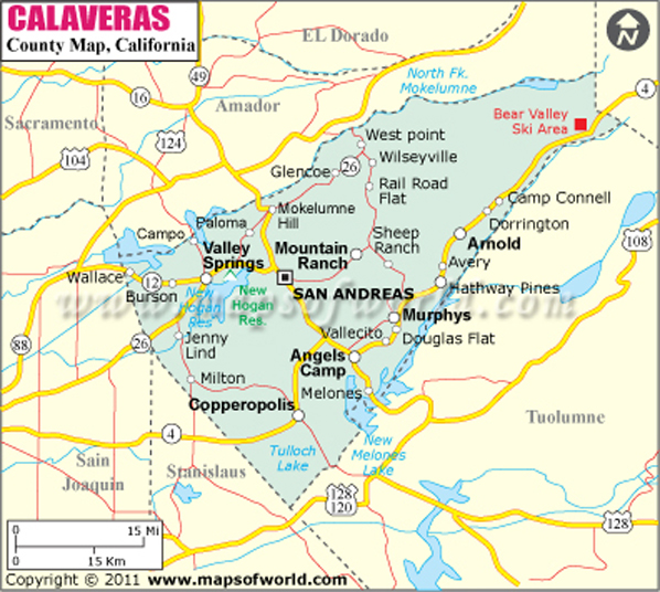
Calaveras County in California
Calaveras County is located in California. Covering an area of 1,037 square miles, Calaveras County is located in the Californian regions of Gold Country and High Sierra. While San Andreas is the county seat, Angels Camp is its only incorporated city. Some prominent cities in the county are Arnold, Dorrington, Forest Meadows, Mountain Ranch, Rail Road Flat, and Valley Springs, to name a few. The county is home to the Calaveras Big Trees State Park, where one would come across Giant Sequoia trees. There are also a number of caverns in Calaveras County. American writer Mark Twain's immortalized the county in his famous story "The Celebrated Jumping Frog of Calaveras County".
The county is well connected to other regions of California as well as the country by the Calaveras County Airport, which is located near San Andreas. San Andreas, Angels Camp and a few other communities are served by the Calaveras Transit. Some major highways that pass through the county are State Route 4, 12,26 and 49.
Get to know some some of the important landmarks of the map such as highways, places of interest, educational institutes, hospitals etc by referring to the map above. The map is suitable for travelers, students, teachers and geographers.
MOW.PB.04.01.2017
Inside the page
Cities in Calaveras County
Mountain Peaks in Calaveras County
| Mountain Peak/Hill | Elevation [Meter] |
|---|
| Abbotts Peak | 471 |
| Bald Hill | 521 |
| Bald Mountain | 668 |
| Bald Mountain | 153 |
| Bald Mountain | 1,247 |
| Barth Mountain | 581 |
| Bear Mountain | 879 |
| Big Dome | 437 |
| Blue Jay Point | 567 |
| Blue Mountain | 1,835 |
| Bostick Mountain | 550 |
| Boucher Mountain | 471 |
| Brunner Hill | 552 |
| Buck Mountain | 1,565 |
| Buena Vista Mountain | 612 |
| Carmen Peak | 786 |
| Carson Hill | 601 |
| Central Hill | 460 |
| Chili Hill | 416 |
| Copperopolis Mountain | 542 |
| Darby Knob | 1,127 |
| Deer Peak | 582 |
| Devils Nose | 1,445 |
| Doud Hill | 1,264 |
| Flagpole Point | 2,413 |
| Flowers Mountain | 477 |
| Fort Mountain | 999 |
| French Hill | 577 |
| Funk Hill | 529 |
| Garnet Hill | 1,369 |
| Golden Gate Hill | 605 |
| Halleck Hill | 666 |
| High Mountain | 748 |
| Hog Hill | 395 |
| Iron Mountain | 298 |
| Italian Point | 385 |
| Joaquin Peak | 854 |
| John Bull Peak | 315 |
| Lightner Peak | 471 |
| Mineral Mountain | 856 |
| Mount Ararat | 679 |
| Mount Ophir | 376 |
| Mountain Top | 520 |
| Negro Hill | 395 |
| Opal Hill | 111 |
| Pine Peak | 405 |
| Quail Hill | 337 |
| Quiggs Mountain | 842 |
| Rattlesnake Hill | 1,031 |
| Red Hill | 673 |
| Rocky Hill | 552 |
| Sand Hill (historical) | 57 |
| Shirley Mountain | 406 |
| Shovel Grave | 2,036 |
| Siberia | 283 |
| Simmons Point | 417 |
| Soapstone Hill | 799 |
| South Hill | 194 |
| Stockton Hill | 538 |
| Sugarloaf | 102 |
| Sugarloaf Hill | 663 |
| Valley Springs Peak | 357 |
| Wally Hill | 540 |
Airports in Calaveras County
| Airport Name |
|---|
| Calaveras Co Maury Rasmussen Field |
| Eagle Ridge Ranch Airport |
| Mark Twain St Joseph's Hospital Heliport |
| Mother Lode Service Center Heliport |
Golf Courses in Calaveras County
| Name of Golf Course | Latitude | Longitude |
|---|
| Forest Meadows Golf Course-Murphys | 38.164899 | -120.409335 |
| Greenhorn Creek Resort-Angels Camp | 38.06626 | -120.553726 |
| La Contenta Golf Course-Valley Springs | 38.171739 | -120.836379 |
| Meadowmont Golf Course-Arnold | 38.247827 | -120.35971 |
| Saddle Creek Golf Club-Copperopolis | 37.918949 | -120.635754 |
| Sequoia Woods Country Club-Arnold | 38.255997 | -120.327754 |
| Trinitas Golf Club-Valley Springs | 38.123814 | -120.938889 |
Last Updated Date: March 06th, 2017


