logo


Butte County Map

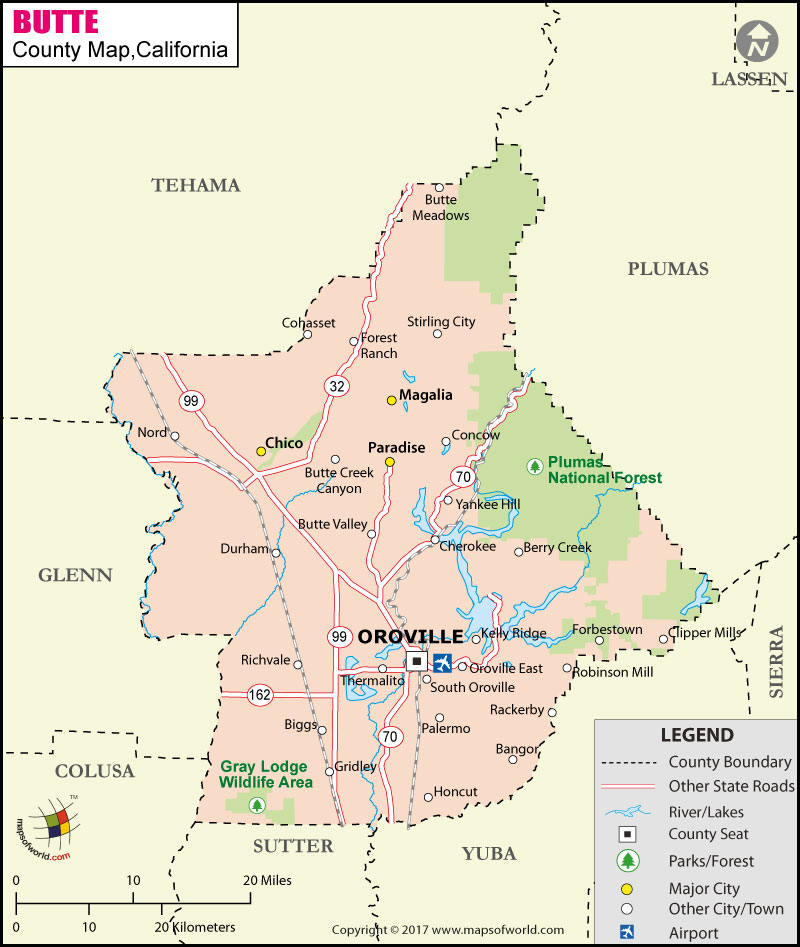
Below is County Map of Butte in California showing the boundaries, roads, highways, towns and much more.

Map of Butte County, California

Butte County Map
Description:Butte County Map showing the County boundaries, County seat, major cities, highways, roads, rail network, airport and point of interest. Disclaimer
×

Disclaimer  :  All efforts have been made to make this image accurate. However MapSherpa, Inc, its directors and employees do not own any responsibility for the correctness or authenticity of the same.


Butte County is located in the upper portion of the Central Valley in Northern California. Spread over an area of 1,677 square miles, the county is widely known as the "Land of Natural Wealth and Beauty." Oroville is the county seat. Nicknamed "City of Trees," Chico is the most populous city in the county.


Oroville Dam, an earth-fill embankment structure on the Feather River, is the tallest dam in the United States. The dam confines Lake Oroville, the second largest reservoir in California. Butte County's 2,500-acre Bidwell park in Chico is one of the largest city parks in the United States. The park features several hiking loops and swimming holes. Feather Falls, Mother Orange Tree, Bidwell Mansion State Historic Park, Gateway Science Museum, and National Yo-Yo Museum are major points of interest in Butte County.


The city of Oroville is considered the gateway to Lake Oroville and Feather River recreational areas. International airport in Sacramento lies about an hour south from the county. State Route 32, SR 70, and SR 99 are major transportation corridors in the county. Chico station is used by Amtrak's Coast Starlight route.

MOW.DT.01.09.17


Inside the page

Facts about Butte County

County NameButte County
FoundedFeb 18, 1850
Area1,677 sq mi (4,340 km2)
Land Area1,636 sq mi (4,240 km2)
Water Area41 sq mi (110 km2)
Population220,000 (2010)
Largest cityChico (population and area)
County SeatOroville
Time zonePacific Standard Time (UTC-8) Summer (DST) Pacific Daylight Time (UTC-7)

Cities in Butte County

CityPopulation (2010)
Bangor646
Berry Creek1,424
Biggs city1,707
Butte Creek Canyon1,086
Butte Meadows40
Butte Valley899
Cherokee69
Chico city86,187
Clipper Mills142
Cohasset847
Concow710
Durham5,518
Forbestown320
Forest Ranch1,184
Gridley city6,584
CityPopulation (2010)
Honcut370
Kelly Ridge2,544
Magalia11,310
Nord320
Oroville city15,546
Oroville East8,280
Palermo5,382
Paradise town26,218
Rackerby204
Richvale244
Robinson Mill80
South Oroville5,742
Stirling City295
Thermalito6,646
Yankee Hill333


Airports in Butte County


Airport Name
Butte Creek Hog Ranch Airport
Chico Municipal Airport
Enloe Hospital Heliport
Johnsen Airport
Jones/Ag-Viation Airport
Lake Oroville Landing Area Seaplane Base
Oroville Municipal Airport
Paradise Skypark Airport
Ranchaero Airport
Richvale Airport
Siller Bros Inc Airport

Mountain Peaks in Butte County

Mountain Peak/HillElevation [Meter]
Bald Mountain1,761
Bald Rock Dome1,022
Bear Ranch Hill1,455
Beauty Peak175
Big Bald Rock990
Big Bar Mountain1,332
Big Bend Mountain777
Bloomer Hill913
Bottle Hill1,609
Bull Hill1,624
Cape Horn895
Castle Rock246
Cherry Hill1,618
Crystal Hill615
Deer Peak391
East China Point1,038
Flatiron239
Flea Mountain1,299
Gold Hill1,523
Gold Hill1,527
Hump Hill557
Hungary Hunt Peak1,227
Island Bar Hill837
Jordan Hill587
Kanaka Peak920
Katskill Hill253
Little Bald Rock1,043
Miller Hill496
Monte de Oro349
Mount Hope618
Mount Ratchel432
Nimshew Ridge723
North Table Mountain477
Oak Point1,617
Parks Hill471
Mountain Peak/HillElevation [Meter]
Patton Peak439
Phoenix Hill611
Platte Mountain1,075
Pompys Point1,214
Portuguese Point1,028
Quartz Hill1,325
Red Hill457
Robbers Roost153
Robley Point882
Rocky Peak496
Rocky Point Peak460
Sausage Mountain275
Sawmill Peak1,004
Serpentine Point549
Shute Mountain1,255
Sky High1,275
Snow Mountain2,127
Sorensen Hill155
South Bidwell Hill598
South Table Mountain320
Steamboat Rock238
Stringtown Mountain717
Sugarloaf488
Sugarloaf Peak167
Sunset Hill1,006
Swain Hill274
Swain Hill1,248
Swayne Hill835
Sycamore Hill221
Table Mountain1,913
The High Rocks465
Union Hill580
Weiss Hill975
West China Point1,003
Wild Yankee Hill811


Golf Courses in Butte County

Name of Golf CourseLatitudeLongitude
Bidwell Park Golf Course-Chico39.768254-121.77866
Butte Creek Country Club-Chico39.683871-121.775634
Canyon Oaks Country Club-Chico39.756502-121.785352
Lake Oroville Golf & Country Club-Oroville39.53212-121.471714
Lava Creek Golf Course-Paradise39.741337-121.607829
Paradise Pines Golf Course-Magalia39.814261-121.592755
Sunset Hills Golf & Country Club-Chico39.786765-121.891731
Table Mountain Golf Course-Oroville39.498146-121.626199
The Tuscan Ridge Club-Paradise39.72005-121.700019

County Maps of California

Alameda County MapMarin County MapSan Luis Obispo County Map
Alpine County MapMariposa County MapSan Mateo County Map
Amador County MapMendocino County MapSanta Barbara County Map
Butte County MapMerced County MapSanta Clara County Map
Calaveras County MapModoc County MapSanta Cruz County Map
Colusa County MapMono County MapShasta County Map
Contra Costa County MapMonterey County MapSierra County Map
Del Norte County MapNapa County MapSiskiyou County Map
El Doredo County MapNevada County MapSolano County Map
Fresno County MapOrange County MapSonoma County Map
Glenn County MapPlacer County MapStanislaus County Map
Humboldt County MapPlumas County MapSutter County Map
Imperial County MapRiverside County MapTehama County Map
Inyo County MapSacramento County MapTrinity County Map
Kern County MapSan Benito County MapTulare County Map
Kings County MapSan Bernardino County MapTuolumne County Map
Lake County MapSan Diego County MapVentura County Map
Lassen County MapSan Francisco County MapYolo County Map
Los Angeles County MapSan Joaquin County MapYuba County Map
Madera County Map 


Map of Cities in California

Long Beach city MapOakland city MapAnaheim city Map
Santa Ana city MapRiverside city MapStockton city Map
Chula Vista city MapFremont city MapIrvine city Map
San Bernardino city MapModesto city MapOxnard city Map
Los Angeles city Map San Francisco city Map Sacramento city Map
San Jose city Map Bakersfield city Map Fullerton city Map


Last Updated Date: September 20th, 2021