logo


Alameda County Map

Below is County Map of Alameda in California showing the boundaries, roads, highways, towns and much more.

Map of Alameda County, California
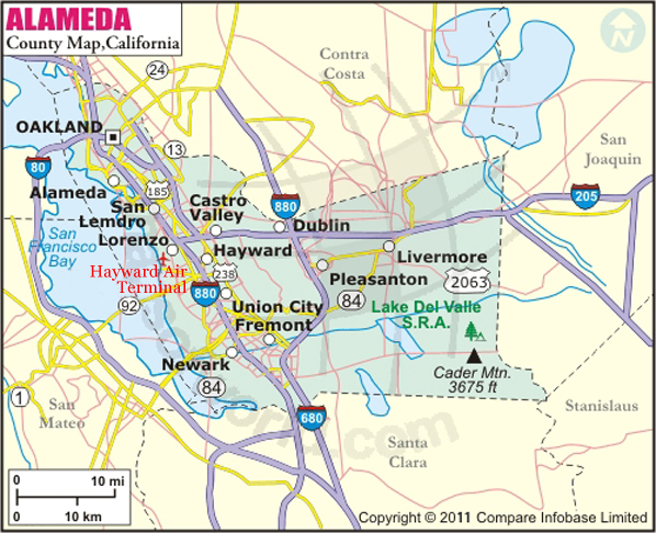
Alameda County Map
Description:Map of Alameda county showing the major towns, highways and much more. Disclaimer
×

Disclaimer  :  All efforts have been made to make this image accurate. However MapSherpa, Inc, its directors and employees do not own any responsibility for the correctness or authenticity of the same.


Inside the page

Facts about Alameda County

County NameAlameda County
FoundedMar 25, 1853
Area821 sq mi (2,130 km2)
Land Area739 sq mi (1,910 km2)
Water Area82 sq mi (210 km2)
Population1,510,271 (2010)
Largest cityOakland (population and area)
County SeatOakland
Time zonePacific Standard Time (UTC-8)Summer (DST) Pacific Daylight Time (UTC-7)

Cities in Alameda County


CityPopulation
Alameda city73,812
Albany city18,539
Ashland21,925
Berkeley city112,580
Castro Valley61,388
Cherryland14,728
Dublin city46,036
Emeryville city10,080
Fairview10,003
Fremont city214,089
Hayward city144,186
Livermore city80,968
Newark city42,573
Oakland city390,724
Piedmont city10,667
Pleasanton city70,285
San Leandro city84,950
San Lorenzo23,452
Sunol913
Union city69,516


Mountain Peaks in Alameda County


Mountain Peak/HillElevation [Meter]
Albany Hill103
Brushy Peak514
Cedar Mountain1121
Discovery Peak1171
Donlan Point332
Grizzly Peak528
Lone Hill256
Lookout Point1054
Maderia Hill75
Maguire Peaks488
Mission Peak762
Mount Allison796
Mount Wallace942
Oak Knoll158
Pill Hill28
Ramage Peak415
Red Hill58
Red Hill Top89
Rose Peak1162
Sugarloaf Butte826
Sunol Peak666
Tolman Peak304
Turk Island34
Vista Grande569

Airports in Alameda County


Airport Name
Alameda County Parking Garage Heliport
Alameda Naval Air Station
Camp Parks Heliport
Children's Hospital Oakland Heliport
First Interstate Bank Operations Center Heliport
Hayward Executive Airport
Livermore Municipal Airport
Meadowlark Field
Metropolitan Oakland International Airport
Naval Hospital Heliport
Oakland Convention Center Heliport
PG&E Livermore Training Center Heliport
Washington Hospital Heliport


Golf Courses in Alameda County


Name of Golf CourseLatitudeLongitude
Callippe Preserve Golf Course-Pleasanton37.627392-121.86055
Castlewood Country Club-Pleasanton37.636553-121.894988
Chuck Corica Golf Complex-Alameda37.739627-122.234142
Claremont Country Club-Oakland37.837613-122.248165
Dublin Ranch Golf Course-Dublin37.725877-121.857165
Fremont Park Golf Course-Fremont37.557863-121.957598
Lake Chabot Golf Course-Oakland37.742992-122.118419
Las Positas Golf Course-Livermore37.696766-121.823616
Metropolitan Golf Links-Oakland37.720599-122.192621
Mission Hills of Hayward Golf Course-Hayward37.6276-122.049282
Monarch Bay Golf Club-San Leandro37.695579-122.186351
Mountain House Golf Course-Mountain House37.7444-121.591806
Pleasanton Golf Center-Pleasanton37.661717-121.880084
Poppy Ridge Golf Course-Livermore37.660771-121.696476
Ruby Hill Golf Club-Pleasanton37.640021-121.816626
Sequoyah Country Club-Oakland37.766019-122.134919
Skywest Golf Course-Hayward37.663067-122.131975
Springtown Golf Course-Livermore37.706138-121.74035
Sunol Valley Golf Courses-Sunol37.575175-121.885667
The Course At Wente Vineyards-Livermore37.622722-121.758377
TPC Stonebrae-Hayward37.646024-122.000602
Willow Park Golf Course-Castro Valley37.724454-122.07979


County Maps of California

Alameda County MapMarin County MapSan Luis Obispo County Map
Alpine County MapMariposa County MapSan Mateo County Map
Amador County MapMendocino County MapSanta Barbara County Map
Butte County MapMerced County MapSanta Clara County Map
Calaveras County MapModoc County MapSanta Cruz County Map
Colusa County MapMono County MapShasta County Map
Contra Costa County MapMonterey County MapSierra County Map
Del Norte County MapNapa County MapSiskiyou County Map
El Doredo County MapNevada County MapSolano County Map
Fresno County MapOrange County MapSonoma County Map
Glenn County MapPlacer County MapStanislaus County Map
Humboldt County MapPlumas County MapSutter County Map
Imperial County MapRiverside County MapTehama County Map
Inyo County MapSacramento County MapTrinity County Map
Kern County MapSan Benito County MapTulare County Map
Kings County MapSan Bernardino County MapTuolumne County Map
Lake County MapSan Diego County MapVentura County Map
Lassen County MapSan Francisco County MapYolo County Map
Los Angeles County MapSan Joaquin County MapYuba County Map
Madera County Map 


Map of Cities in California

Long Beach city MapOakland city MapAnaheim city Map
Santa Ana city MapRiverside city MapStockton city Map
Chula Vista city MapFremont city MapIrvine city Map
San Bernardino city MapModesto city MapOxnard city Map
Los Angeles city Map San Francisco city Map Sacramento city Map
San Jose city Map Bakersfield city Map Fullerton city Map


Last Updated Date: September 20th, 2021