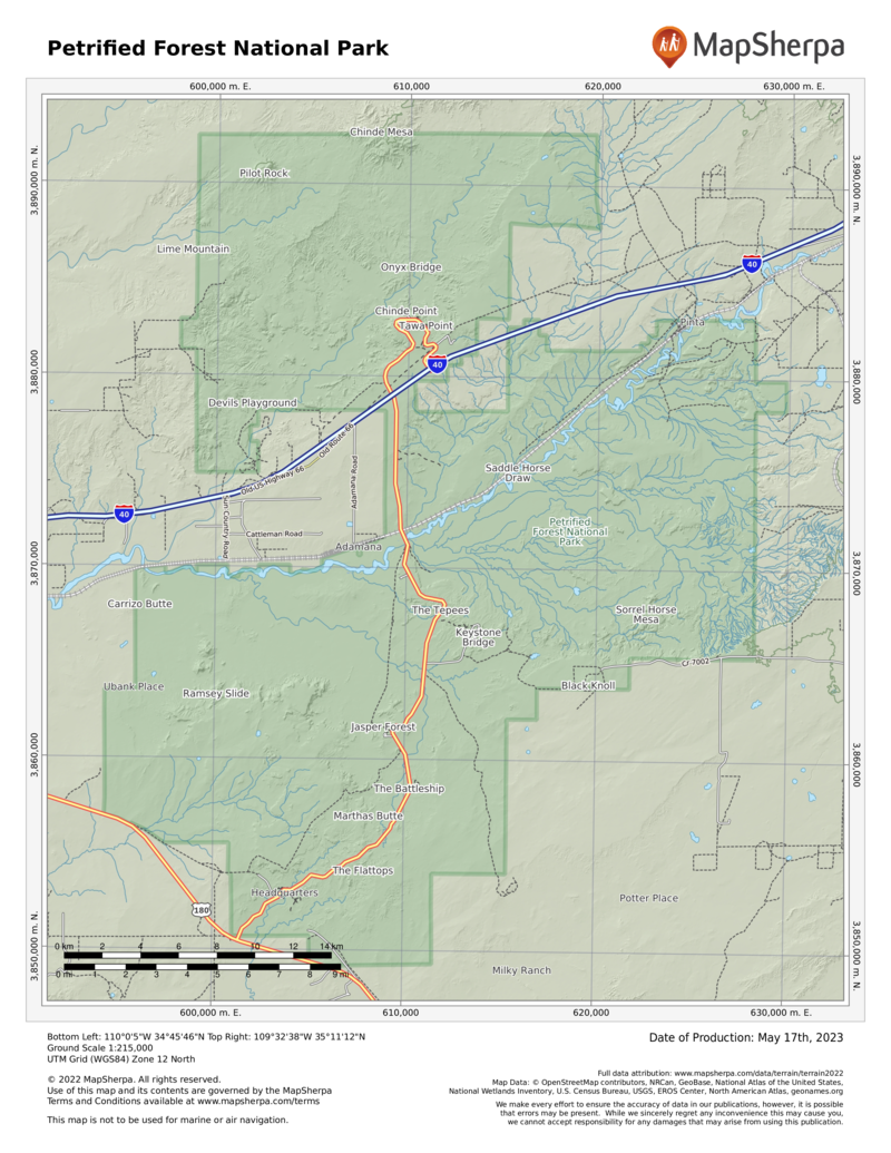
Although every one of America’s 50 states has deposits of petrified wood, Petrified Forest National Park has one of the greatest concentrations of petrified logs on Earth. The display is spectacular. Several easy hiking trails in the park lead to jumbled masses of downed trees that slowly, cell by cell, turned from wood to stone from 205 to 225 million years ago.
Petrified wood fractures easily, so there’s a wide range of sizes to dazzle visitors—from tiny chips and shards to chunks of rock to entire logs stretching from trunk base to treetop on the desert floor. Colors glisten in the sun.
The park’s recent history hinges on transportation. In 1853, the federal government sent a party of soldiers to explore the 35th parallel as a possible transcontinental route. Between 1857 and 1860, a wagon road was built (a portion of which would become part of Route 66). The railroad came through in the early 1880s. Road and rail access soon brought settlers and tourists to the region.
In 1895, the Territory of Arizona stepped in to protect the area, which had been exploited by individuals taking petrified wood. The colorful stone was being hauled off by the wagonload to be used for tabletops, lamps, and mantels; it was also being dynamited to reveal, it was hoped, amethyst and other quartz crystals. A 1900 report by a paleobotanist prompted further protection.
President Theodore Roosevelt created the Petrified Forest National Monument in 1906 to protect the unique environment. In 1932 the monument was expanded to include more than 93,000 acres. In 1970, eight years after the national park was signed into law, some 50,000 acres of the park were designated Wilderness. Legislation in 2004 more than doubled the size of the park. Federal law prohibits the collection and removal of petrified wood—even the tiniest chips.
But Petrified Forest is much more than scenic beauty and iconic geology. Fossilized here are some of the earliest dinosaurs (including the soaring, leathery-winged pterosaurs) and more than 80 species of animals and plants. The area’s human history reaches back 13,000 years, and among the riches of the park are ruins and petroglyph sites that date back some 1,000 years.
How to Visit
Of all the national parks, Petrified Forest ranks among the most susceptible to the drive-through visit. It is easy for the visitor to cruise along, stopping to gaze over the Painted Desert, and walk a short trail among the giant logs before returning to the freeway. To do this, however, is to miss the secrets awaiting in the 346-square-mile park.
A 28-mile paved road bisects the park from north to south. Casual visitors who come for even a couple of hours can drive the road, stop at the excellent museum and visitor center, walk into the petrified groves, and be on their way.
By spending a full day, visitors can spend more time at the museum and visitor center, stop leisurely at the many informational scenic overlooks, and take their time hiking a half dozen short, mostly easy, trails.
The north entrance to the park is an exit off I-40, about 25 miles east of Holbrook, Arizona; the south entrance is about 19 miles east of Holbrook on U.S. 180. The park can be explored from either direction. Here we will start in the north; simply reverse this tour if you are starting in the south.
Information
How to get there
The park is 110 miles east of Flagstaff. From Holbrook, AZ, follow I-40 east for about 25 miles to the north park entrance or U.S. 180 east about 19 miles to the south park entrance.
When to go
Petrified Forest National Park is open year-round. Summer is the most popular season. It can be quite hot, and sudden thunderstorms can mean lightning and high winds. The more temperate fall is a good time to visit, as is winter, when occasional light snows dust the petrified logs. Spring brings pleasant temperatures and blooming wildflowers.
Visitor Center, Museum & National Historic Landmark
The Painted Desert Visitor Center, just outside the north entrance, has exhibits, rangers on duty, and the Timeless Impressions film, which captures the geology and history of the park. The Painted Desert Inn National Historic Landmark, a former lodge, has Route 66 memorabilia and other historic displays. The Rainbow Forest Museum, inside the park’s south entrance, offers dioramas, fossils, and a film.
Headquarters
Petrified Forest National Park 1 Park Road Petrified Forest, AZ 86028 nps.gov/pefo 928-524-6228
Camping
There are no designated camping sites in the park. Overnight backcountry permits are free and available at the visitor center.
Lodging
Though no lodging is available in the park, there is a restaurant and a gas station at the Painted Desert Visitor Center. Holbrook (holbrookchamberofcommerce.com) has a wide range of motels and restaurants.

