“It is by far the grandest of all the special temples of Nature I was ever permitted to enter,” naturalist and conservationist John Muir wrote of Yosemite. From the remote rocky crags of the High Sierra Nevada at the western perimeter of the park to the sinuous meanders of the placid Merced River in Yosemite Valley, Yosemite is a symphony of contrasts: the percussion of cascading waterfalls, the hum of breezes through cedar and pine, the thrum of a sudden rainfall. The abundant wildlife adds its own pageant of sound—the chattering of a western gray squirrel, the screech of a Steller’s jay, the lonely howl of a coyote, the squeak of a tiny pika high in its rocky home.
In addition to sounds, Yosemite is also a contrast of sights and experiences. On a busy summer weekend, more than 20,000 visitors can throng Yosemite Valley, with resulting crowds, noise, and traffic jams. Just a mile or two along a trail, though, can place a hiker in welcome seclusion, with the opportunity to truly appreciate the park.
But no matter how crowded, the park continues to serve up its treasures. Sights and sounds remain thrilling no matter how many people are experiencing them. And whatever the time of year, you can pretty well depend on having sunrise all to yourself.
An overnight or weeklong backpacking trip into the high country can be transformational. “Climb the mountains and get their good tidings,” encouraged John Muir
The protection of Yosemite lands had its beginnings during the Civil War. On June 30, 1864, answering the vigorous campaign of early conservationists, President Abraham Lincoln signed into law a bill protecting Yosemite Valley and the Mariposa Grove of sequoias, granting their oversight to the state of California. Never before had a government set aside wilderness lands to be preserved forever.
In the late 1880s, John Muir and others spoke convincingly to protect more of the Yosemite region by establishing it as a national park— following the example of Yellowstone. In 1890, Congress set aside 1,500 square miles as Yosemite National Park; Yosemite Valley and the Mariposa Grove became part of the national park in 1906.
How to Visit
Yosemite is extensive. A one-day tour of Yosemite Valley reveals exceptional natural beauty and geology but shortchanges visitors when it comes to the diverse nature of the park. An itinerary of three to four days gives you a chance to visit more than just the high points.
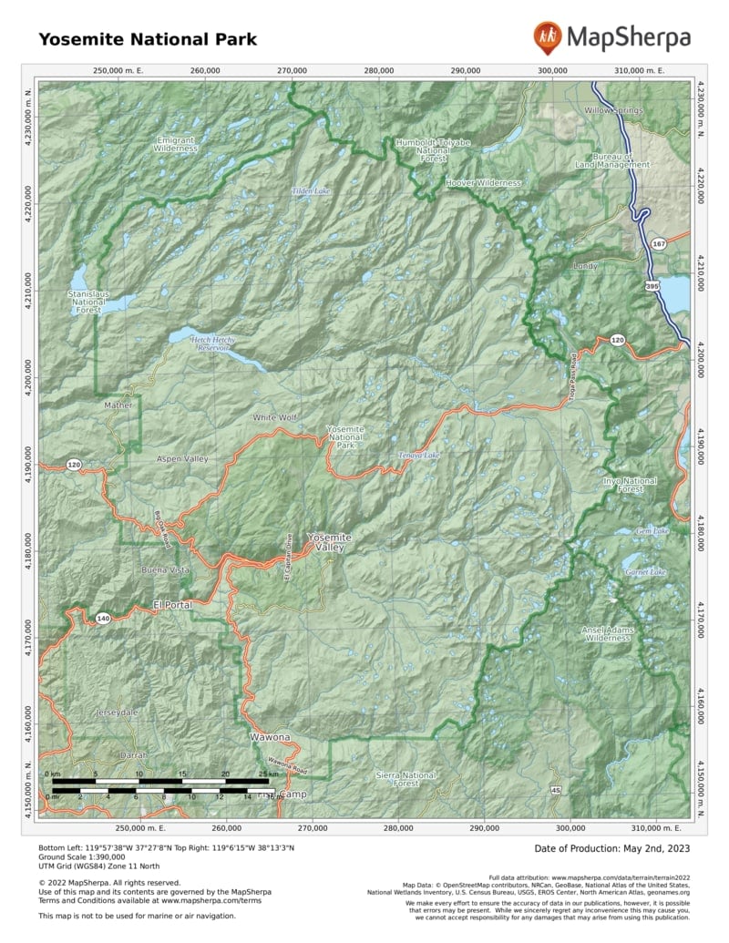
In addition to a day’s hiking and sightseeing in Yosemite Valley, a one-day drive to the inspiring vistas of Glacier Point, on the way to the Wawona area and Mariposa Grove of sequoias, adds dimension to your visit. Or choose to take a full day to drive along the Tioga Road to the wondrous Tuolumne Meadows, high in the Sierra. Or drive to Hetch Hetchy to see a canyon that once rivaled Yosemite Valley.
Information
How to get there
From Oakhurst (about 15 miles south) take Calif. 41 to the South Entrance. From Mariposa (about 25 miles west) take Calif. 140 to the Arch Rock Entrance. From Groveland (about 25 miles northwest) take Calif. 120 to the Big Oak Flat Entrance. From Lee Vining (about 10 miles east) take Calif. 120 to the Tioga Pass Entrance. The Yosemite Area Regional Transportation System (YARTS) offers bus service from Fresno, Merced, Sonora, and Mammoth Lakes.
When to go
Yosemite is open year-round, although the Glacier Point Road from Badger Pass Ski Area to Glacier Point and the Tioga Road to Tuolumne Meadows can be closed mid-Nov. to late May, depending on weather. In general, avoid holiday weekends and expect crowded conditions in Yosemite Valley during late spring, summer, and early fall. Winter can bring heavy snows to the high country and light to moderate snows at lower elevations.
Visitor Centers And Museum
The Valley Visitor Center is next to the Yosemite Museum, which focuses on the Miwok and Paiute peoples’ cultural history. The Happy Isles Art and Nature Center and the Tuolumne Meadows Visitor Center are open in summer. Big Oak Flat Welcome Center Complex and Wawona Visitor Center are open spring to fall.
Headquarters
9039 Village Drive Yosemite National Park, CA 95389 nps.gov/yose 209-372-0200
Camping
There are 13 campgrounds in the park (total of 1,445 sites).
Lodging
A wide variety of accommodations are available, from hotels to cabins. For lodging information, visit yosemite.com/lodging.
US National Parks Map
About the Guide


