Historic Earthquakes in Russia |
 |
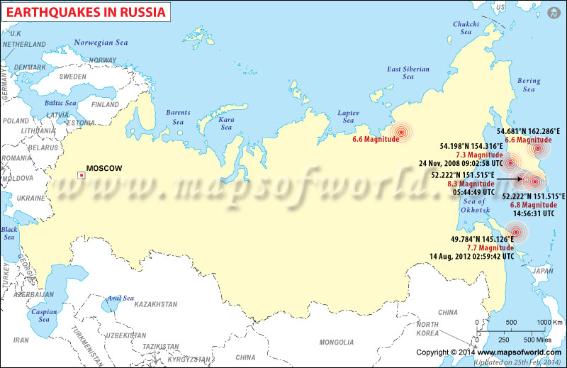
Map showing the epicenter of all major earthquakes occured in Russia. |
Earthquakes in Russia
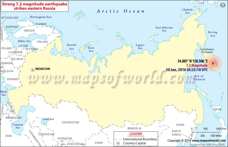
Location of M7.2 earthquake in Russia

| Description :Map showing the epicenter of M7.2 earthquake in Russia on Jan 30, 2016 |
| Disclaimer |
*We specifically create maps that have a magnitude of 6 or more on the Richter Scale.
M7.2 Earthquake hits Russia on Jan 30, 2016
People of eastern Russia woke up to a strong earthquake weighing 7.0 on the Richter scale on Saturday, the US Geological Survey said. The epicenter of the quake was traced to a depth of 160 kilometres (100 miles), about 95 kilometres northeast of the Russian town of Yelizovo. According to sources, no damages and injuries were reported. The quake occurred in a place close to the Ring of Fire which is usually prone to frequent earthquakes and volcanic eruptions
| Earthquakes in Russia | |||
| Date | Location | Magnitude | Fatalities |
|---|---|---|---|
| Feb 3, 1923 | Kamchatka | M 8.5 | |
| Nov 4, 1952 | Kamchatka | M 9.0 | |
| Jun 27, 1957 | Stanovoy Mountains, Russia (USSR) | M 7.6 | |
| Nov 6, 1958 | Kuril Islands | M 8.3 | |
| Oct 13, 1963 | Kuril Islands | M 8.5 | |
| May 27, 1995 | Sakhalin Island | M 7.1 | Fatalities 1,989 |
| Dec 5, 1997 | Near East Coast of Kamchatka | M 7.8 | |
| Nov 17, 2002 | Kuril Islands, Russia | M 7.3 | |
| Jul 27, 2003 | Primor'ye, Russia | M 6.8 | |
| Sep 27, 2003 | Southwestern Siberia, Russia | M 7.3 | Fatalities 3 |
| Oct 1, 2003 | Southwestern Siberia, Russia | M 6.7 | |
| Dec 5, 2003 | Komandorskiye Ostrova, Russia Region | M 6.7 | |
| Jun 10, 2004 | Kamchatka Peninsula, Russia | M 6.9 | |
| Apr 20, 2006 | Koryakia, Russia | M 7.6 | |
| Nov 15, 2006 | Kuril Islands | M 8.3 | |
| Jan 13, 2007 | East of the Kuril Islands | M 8.1 | |
| Apr 7, 2009 | Kuril Islands | M 6.9 | |
| Apr 18, 2009 | Kuril Islands | M 6.6 | |

