| Earthquakes in Papua New Guinea | |||
| Date | Location | Magnitude | Fatalities |
|---|---|---|---|
| Jul 17, 1998 | Near North Coast of New Guinea, Papua New Guinea | M 7.0 | |
| May 10, 1999 | New Britain region, Papua New Guinea | M 7.1 | |
| May 16, 1999 | New Britain region, Papua New Guinea | M 7.1 | Fatalities 2,183 |
| Nov 16, 2000 | New Ireland Region, Papua New Guinea | M 8.0 | Fatalities 2 |
| Nov 16, 2000 | New Ireland Region, Papua New Guinea | M 7.8 | |
| Nov 17, 2000 | New Britain region, Papua New Guinea | M 7.8 | |
| Sep 8, 2002 | New Guinea, Papua New Guinea | M 7.6 | Fatalities 4 |
| Jan 10, 2003 | New Ireland, Papua New Guinea, region | M 6.7 | |
| Mar 11, 2003 | New Ireland Region, Papua New Guinea | M 6.8 | |
| Jun 7, 2003 | New Britain region, Papua New Guinea | M 6.6 | |
| Sep 9, 2005 | New Ireland Region, Papua New Guinea | M 7.6 | |
| Sep 29, 2005 | New Britain region, Papua New Guinea | M 6.6 | |
| Dec 11, 2005 | New Britain region, Papua New Guinea | M 6.6 | |
| Sep 1, 2006 | Bougainville Region, Papua New Guinea | M 6.8 | |
| Oct 17, 2006 | New Britain region, Papua New Guinea | M 6.7 | |
| Jun 28, 2007 | Bougainville region, Papua New Guinea | M 6.7 | |
| Sep 26, 2007 | New Ireland Region, Papua New Guinea | M 6.8 | |
| Nov 22, 2007 | Eastern New Guinea Region, Papua New Guinea | M 6.8 | |
| Jun 23, 2009 | New Ireland region, Papua New Guinea | M 6.7 | |
Papua New Guinea Earthquake Map
Papua New Guinea Earthquake map
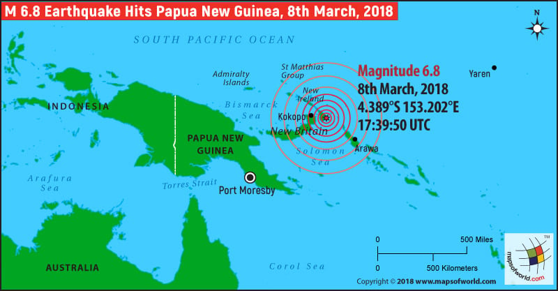
| Description :Map showing the location of earthquake in Papua New Guinea on March 8, 2018 |
| Disclaimer |
*We specifically create maps that have a magnitude of 6 or more on the Richter Scale.
Also Explore: Where is Papua New Guinea ?, Papua New Guinea Map
6.8 magnitude earthquake hits Papua New Guinea
Papua New Guinea was struck by a 6.8 magnitude earthquake early Friday. Media reports quoted officials as saying that no immediate damage has been reported and there have been no warnings of tsunami. The earthquake had a depth of 15km and struck around 20 km offshore of the town of Taron in New Ireland.
6.7 magnitude earthquake strikes Papua New Guinea: 18 dead
A 6.7 magnitude earthquake struck Papua New Guinea on early Wednesday. According to media reports, the earthquake claimed at least 18 lives. The earthquake, which struck in the country's Southern Highlands, added to the death toll resulting from a larger earthquake that shook the nation last week. The tremor occurred juts 31 kms southwest of the epicenter of last week's earthquake.
Major Earthquake of Magnitude 7.5 hits Papua New Guinea
A major earthquake has struck the middle of Papua New Guinea early on this Monday. According to the reports of The U.S. Geological Survey the 7.5 magnitude earthquake hit about 89 kilometers (55 miles) southwest of Porgera in the Pacific island nation. No warnings of tsunami have been issued. No severe damage is observed although minor casualties are reported. Papua New Guinea sits on the “Ring of Fire” on the Pacific. Earthquakes are common in Papua New Guinea as it is a hotspot for seismic activity due to friction between tectonic plates.
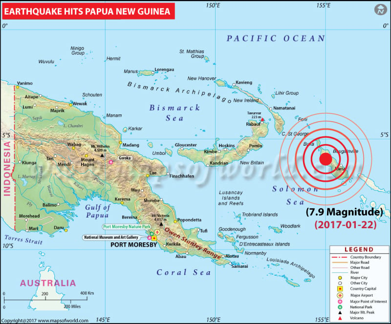
Magnitude-7.9 Earthquake strikes Papua New Guinea:
2017-01-22 04:30:23 UTC: A magnitude-7.9 earthquake has struck 47 kilometres west of Arawa on Bougainville Island in Papua New Guinea at a depth of 136 kilometres, the United States Geological Survey says.
The Pacific Tsunami Warning Centre (PTWC) said in an advisory that "hazardous tsunami waves are possible" for the next three hours as a result of the earthquake along the coasts of PNG and the Solomon Islands.
The Pacific Tsunami Warning Centre (PTWC) said in an advisory that "hazardous tsunami waves are possible" for the next three hours as a result of the earthquake along the coasts of PNG and the Solomon Islands.
Massive Earthquake Strikes Papua New Guinea, Tsunami Alert Issued
2016-12-17 10:51:12 UTC: A massive earthquake of magnitude 7.9 has struck off the east coast of Papua New Guinea, according to latest news reports. The Pacific Tsunami Warning Centre has said that widespread hazardous tsunami waves are likely in the next three hours along some coasts of Papua New Guinea, Indonesia, the Solomon Islands, Nauru and other islands. While New Zealand's Ministry of Civil Defence has issued a warning for the country's entire coast, the Joint Australian Tsunami Warning Centre has said there is no tsunami threat to the Australian mainland, islands or territories. Papua New Guinea sits on the earthquake-prone Ring of Fire. The quake occurred at 9:51 P.M. local time 60 kilometers east of Taron on New Ireland island at a depth of 73.4 kilometers.
2016-12-17 10:51:12 UTC: A massive earthquake of magnitude 7.9 has struck off the east coast of Papua New Guinea, according to latest news reports. The Pacific Tsunami Warning Centre has said that widespread hazardous tsunami waves are likely in the next three hours along some coasts of Papua New Guinea, Indonesia, the Solomon Islands, Nauru and other islands. While New Zealand's Ministry of Civil Defence has issued a warning for the country's entire coast, the Joint Australian Tsunami Warning Centre has said there is no tsunami threat to the Australian mainland, islands or territories. Papua New Guinea sits on the earthquake-prone Ring of Fire. The quake occurred at 9:51 P.M. local time 60 kilometers east of Taron on New Ireland island at a depth of 73.4 kilometers.
| Origin Details | |
|---|---|
| Magnitude | 7.9 mww |
| Location (uncertainty) | 4.509°S 153.450°E± 7.4 km |
| Depth (uncertainty) | 103.2 km± 4.3 |
| Origin Time | 2016-12-17 10:51:12.570 UTC |
| Number of Phases | 133 |
| Minimum Distance | 146.9 km (1.32°) |
| Travel Time Residual | 1.06 s |
| Azimuthal Gap | 17° |
| FE Region | NEW IRELAND REGION, PAPUA NEW GUINEA (190) |
Powerful 6.3 magnitude earthquake strikes off Papua New Guinea
A massive earthquake struck off the coast of Bougainville Island in Papua New Guinea. According to media reports, no immediate tsunami warnings have been issued. The US Geological Survey said the 6.4 magnitude earthquake struck around 96 kilometers southwest of Panguna. The epicenter of the earthquake was 102 kilometers southwest of Arawa located on Bougainville Island.
Papua New Guinea Earthquake map |
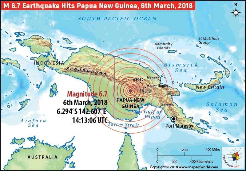 |
Map showing the location of earthquake in Papua New Guinea on March 6, 2018 |
Papua New Guinea Earthquake map |
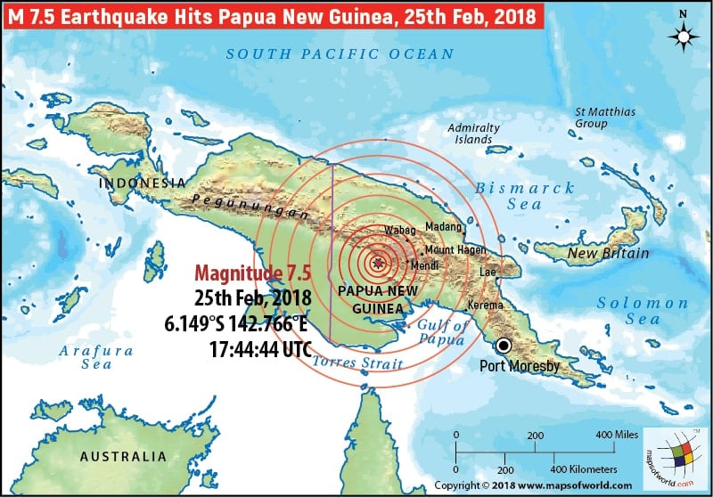 |
Map showing the location of earthquake in Papua New Guinea on Feb 25, 2018 |
Papua New Guinea Earthquake map |
 |
Papua New Guinea Earthquake map |
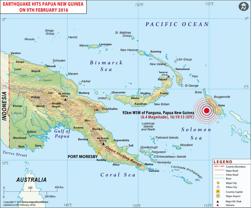
Earthquake in Papua New Guinea on Feb 09, 2016 |
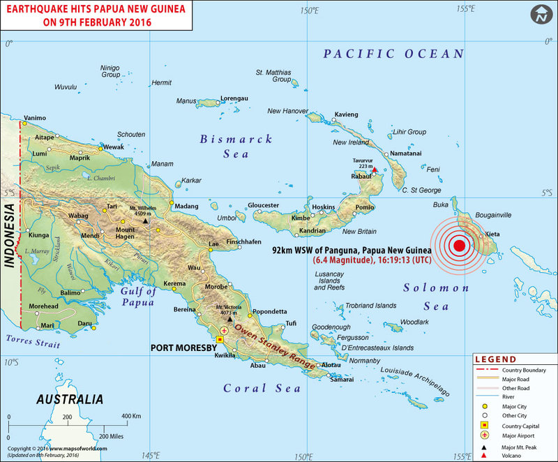 |
Map showing the location of earthquake in Papua New Guinea on Feb 09, 2016 |
Historic Earthquakes in Papua New Guinea |
 |
Map shows the epicentres of all major Earthquakes in Papua New Guinea |

