5.6-magnitude earthquake in California |
 |
5.6-magnitude earthquake in California |
5.2-magnitude earthquake in California |
 |
5.2-magnitude earthquake in California |
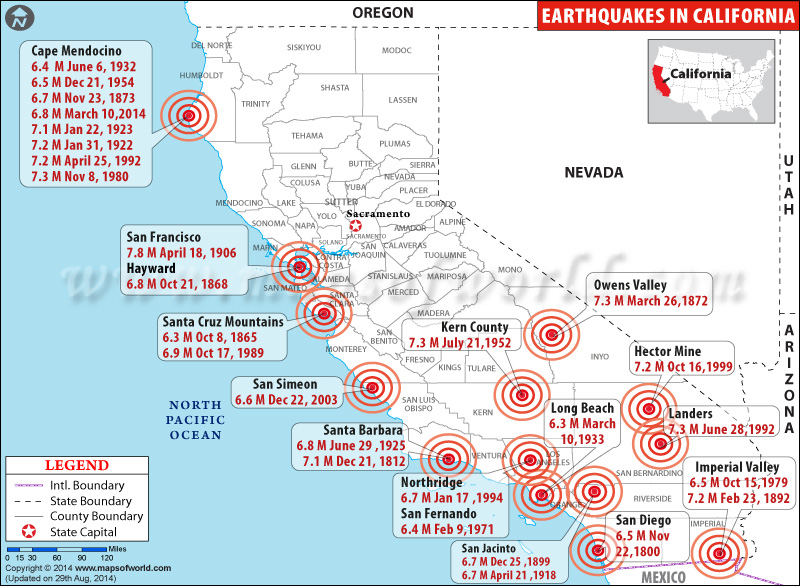
California Earthquake Map - Affected Areas |
 |
Map showing the location of earthquakes in California. |
California Earthquake Map
6.5 Magnitude Earthquake in California

| Description :6.5-magnitude earthquake in California |
| Disclaimer |
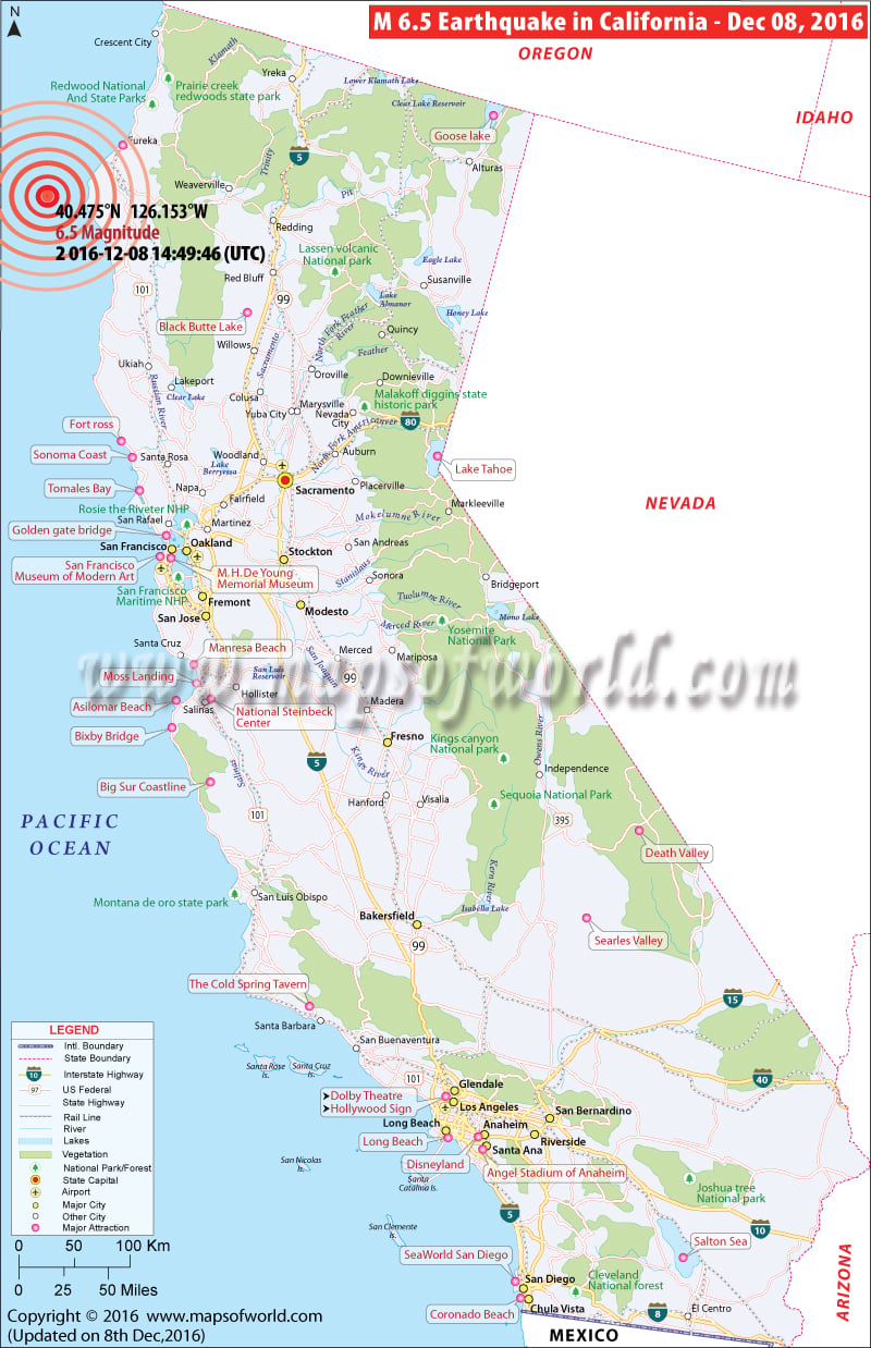
6.5 Magnitude Earthquake Hits California coast
2016-12-08 14:49:46 UTC: A 6.5-magnitude earthquake shook the ocean floor about 100 miles off the northern California coast.The quake, centered about 102 miles west of Ferndale, California. No tsunami threat is expected from the quake, the Pacific Tsunami Warning Center said. There were no immediate reports of injuries or serious damage.
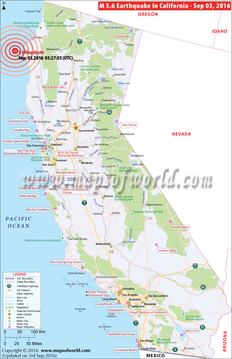
5.6 Magnitude Earthquake Hits Ferndale in California
Sep 3, 2016, 12:30 AM: A 5.6 magnitude earthquake has hit the coast near Ferndale in Humboldt County of California on Saturday. The epicenter was 60 miles away from the Pacific Ocean. There is no report of any damage or casualties so far. Also there is no warning of any more land shaking and even tsunami.
View California Map, Where is California?
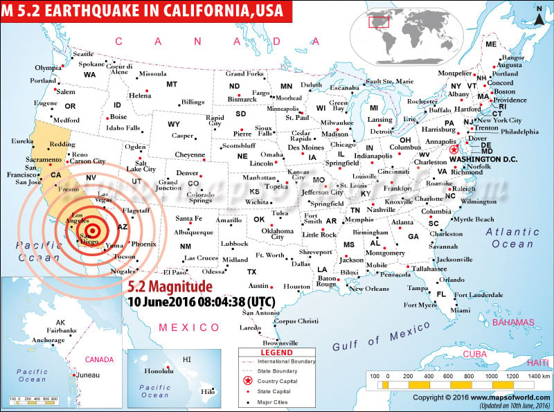
5.2-magnitude earthquake strikes Borrego Springs
2016-06-10 08:04:38 (UTC): A 5.2-magnitude earthquake struck some 13 miles north-northwest of Borrego Springs in California. The earthquake, which struck early Friday, was felt across a large part of Southern California. The epicenter of the earthquake was located around 10 miles north of the town of Borrego Springs, which is around 95 miles northeast of San Diego. There are no reports of damage or casualties.
| YEAR | DATE | UTC TIME | LOCATION | MAGNITUDE | |
|---|---|---|---|---|---|
| 2016 | Sep 3 | 03:27:55 UTC | Ferndale, California | 5.6 | |
| 2014 | March 10 | 05:18:00 AM | 09:18:00 PM | Cape Mendocino | 6.8 |
| 2014 | August 24 | 10:20:00 AM | 03:20:00 AM | 6km NW of American Canyon, California | 6 |
| 2012 | December 14 | 10:36:00 AM | 02:36:00 AM | Off the southwest coast of Catalina Island | 6.3 |
| 2010 | January 10 | 12:27:00 AM | 04:27:00 PM | Cape Mendocino | 6.5 |
| 2010 | April 04 | 10:40:00 PM | 03:40:00 PM | northern Baja California | 7.2 |
| 2005 | June 12 | 03:41:00 PM | 08:41:00 AM | Anza | 5.2 |
| 2005 | June 15 | 02:50:00 AM | 07:50:00 PM | Cape Mendocino | 7.2 |
| 2004 | September 28 | 05:15:00 PM | 10:15:00 AM | Parkfield | 6 |
| 2003 | December 22 | 07:15:00 PM | 11:15:00 AM | San Simeon | 6.6 |
| 1999 | October 16 | 09:46:00 AM | 02:46:00 AM | Hector Mine | 7.2 |
| 1994 | January 17 | 12:30:00 PM | 04:30:00 AM | Northridge | 6.7 |
| 1993 | May 17 | 11:20:00 PM | 04:20:00 PM | Eureka Valley | 6 |
| 1992 | April 23 | 04:50:00 AM | 09:50:00 PM | Joshua Tree | 6.1 |
| 1992 | April 25 | 06:06:00 PM | 11:06:00 AM | Cape Mendocino | 7.2 |
| 1992 | June 28 | 11:57:00 AM | 04:57:00 AM | Landers | 7.3 |
| 1992 | June 28 | 03:05:00 PM | 08:05:00 AM | Big Bear | 6.5 |
| 1991 | June 28 | 02:43:00 PM | 07:43:00 AM | Sierra Madre | 5.6 |
| 1989 | October 17 (local) | 12:04:00 AM | 05:04:00 PM | Santa Cruz Mountains | 6.9 |
| 1987 | October 01 | 02:42:00 PM | 07:42:00 AM | Whittier Narrows | 5.9 |
| 1987 | November 23 & 24 | 01:54:00 AM | 05:54:00 PM | Elmore Desert Ranch | 6 |
| 1987 | November 24 | 02:15:00 PM | 06:15:00 AM | Superstition Hills | 6.5 |
| 1986 | July 08 | 09:20:00 AM | 02:20:00 AM | North Palm Springs | 6 |
| 1986 | August 21 | 02:42:00 PM | 07:42:00 AM | Chalfant Valley | 6.2 |
| 1984 | April 24 | 09:15:00 PM | 01:15:00 PM | Morgan Hill | 6.2 |
| 1983 | May 02 | 10:42:00 PM | 03:42:00 PM | Coalinga | 6.4 |
| 1980 | November 08 | 10:27:00 AM | 02:27:00 AM | Cape Mendocino | 7.3 |
| 1954 | March 19 | 09:54:00 AM | 01:54:00 AM | west of Salton City | 6.4 |
| 1954 | December 21 | 07:56:00 PM | 11:56:00 AM | Cape Mendocino | 6.5 |
| 1952 | July 21 | 11:52:00 AM | 04:52:00 AM | Kern County | 7.3 |
| 1948 | December 04 | 11:43:00 PM | 03:43:00 PM | near Desert Hot Springs | 6.5 |
| 1947 | April 10 | 03:58:00 PM | 07:58:00 AM | Newberry Springs | 6.5 |
| 1942 | October 21 | 04:22:00 PM | 09:22:00 AM | Fish Creek Mountains | 6.6 |
| 1940 | May 19 | 04:36:00 AM | 08:36:00 PM | Imperial Valley | 6.9 |
| 1937 | March 25 | 04:49:00 PM | 08:49:00 AM | Anza, Hemet, and Palm Springs | 5.6 |
| 1933 | March 10 (local) | 01:54:00 AM | 05:54:00 PM | Long Beach | 6.3 |
| 1932 | June 06 | 08:44:00 AM | 12:44:00 AM | Cape Mendocino | 6.4 |
| 1927 | November 04 | 01:51:00 PM | Point Arguello | 7 | |
| 1925 | June 29 | 02:44:00 PM | 06:44:00 AM | Santa Barbara | 6.8 |
| 1923 | January 22 | 09:04:00 AM | 01:04:00 AM | Cape Mendocino | 7.1 |
| 1922 | January 31 | 01:17:00 PM | Cape Mendocino | 7.2 | |
| 1918 | April 21 | 10:32:00 PM | 02:32:00 PM | San Jacinto | 6.7 |
| 1911 | July 01 | 10:00:00 PM | Coyote | 6.6 | |
| 1906 | April 18 | 01:12:00 PM | 05:12:00 AM | San Francisco | 7.8 |
| 1899 | December 25 | 12:25:00 PM | 04:25:00 AM | San Jacinto | 6.7 |
| 1898 | March 31 | 07:43:00 AM | Mare Island | 6.2 | |
| 1898 | April 15 | 07:07:00 AM | Greenwood | 6.9 | |
| 1892 | February 23 | 07:20:00 AM | 11:20:00 PM | Imperial Valley | 7.2 |
| 1892 | April 19 | 10:50:00 AM | 02:50:00 AM | Vacaville | 6.4 |
| 1892 | April 21 | 05:43:00 PM | 09:43:00 AM | Winters | 6.2 |
| 1873 | November 23 | 05:00:00 AM | Cape Mendocino | 6.7 | |
| 1872 | March 26 | 10:30:00 AM | 02:30:00 AM | Owens Valley | 7.3 |
| 1868 | October 21 | 03:53:00 PM | 07:53:00 AM | Hayward | 6.8 |
| 1865 | October 08 | 08:46:00 PM | 12:46:00 PM | Santa Cruz Mountains | 6.3 |
| 1857 | January 09 | 04:24:00 PM | 08:24:00 AM | Parkfield-Wrightwood | 7.9 |
| 1838 | June | San Francisco Peninsula | 7 | ||
| 1812 | December 08 | 03:00:00 PM | 07:00:00 AM | Wrightwood | 6.9 |
| 1812 | December 21 | 07:00:00 PM | 11:00:00 AM | Santa Barbara | 7.1 |
| 1800 | Novembber 22 | 09:30:00 PM | 01:30:00 PM | San Diego | 6.5 |
| 1769 | July 28 | 09:00:00 PM | 01:00:00 PM | Santa Ana River | 6 |

