Map showing recent Earthquake in Chile |
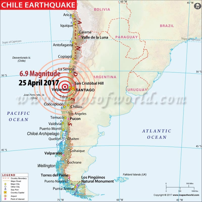 |
Chile Earthquake Map |
Map showing recent Earthquake in Chile |
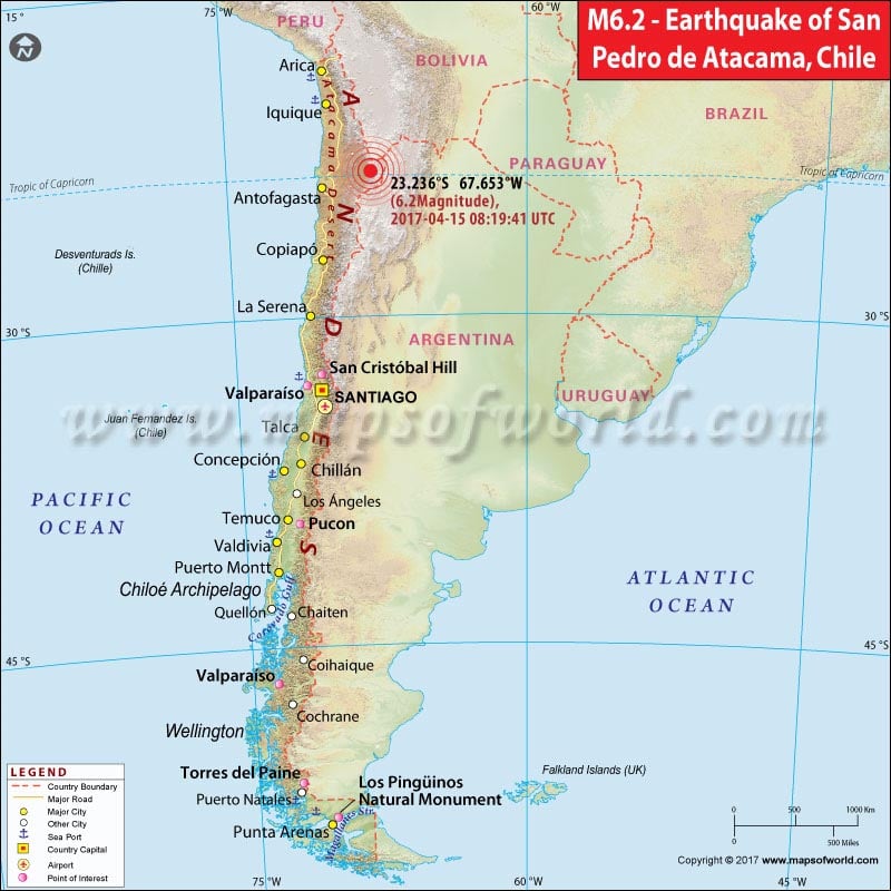 |
Chile Earthquake Map |
Chile Location Map |
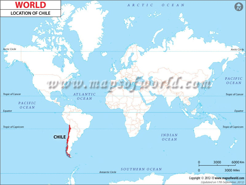 |
Chile Location Map |
M8.3 and M6.3 earthquakes in Chile |
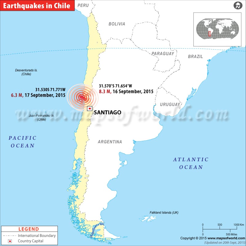 |
Map showing the epicenter of Earthquakes in Chile. |
M6.4 Earthquake hits Chile- June20, 2015 |
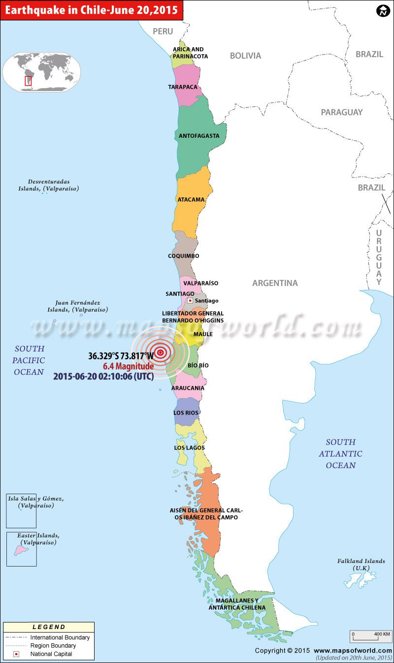 |
Map showing the epicenter of M6.4 earthquake in Chile on June 20, 2015- 02:10:06 (UTC) |
M6.0 Earthquake hits Chile- June10, 2015 |
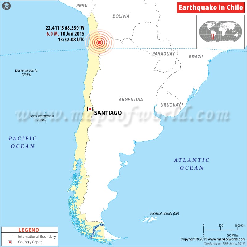 |
Map showing the epicenter of M6.0 earthquake in Antofagasta, Chile on June 10, 2015. |
Earthquakes in Chile from 1998 to 2014 |
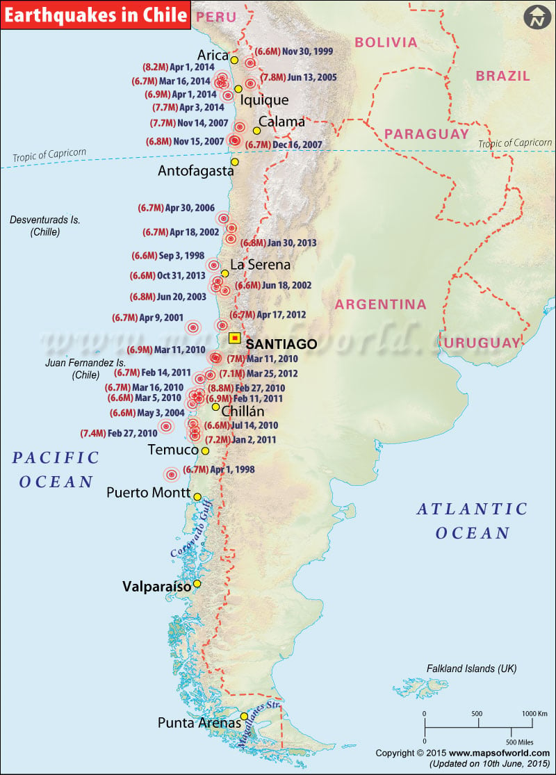 |
Map showing the epicenter for major Earthquakes in Chile from 1998 to 2014. |
Earthquakes in Chile from 1975 to 1998 |
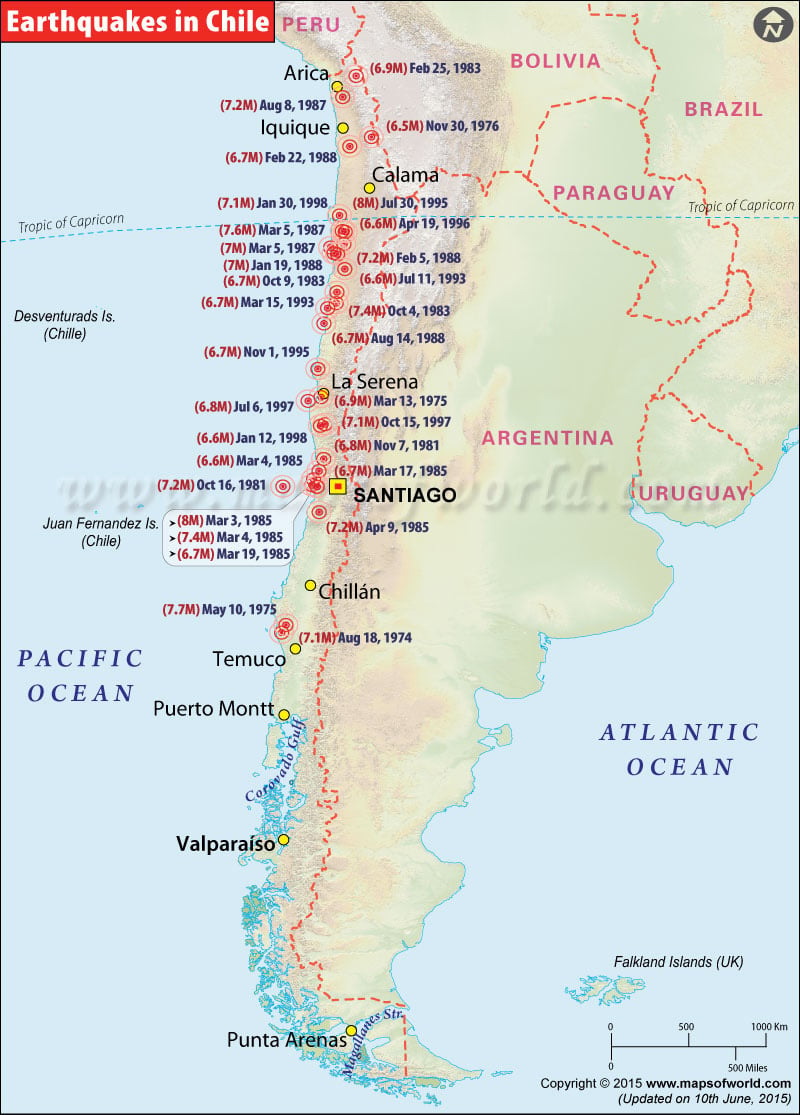 |
Map showing the epicenter for major Earthquakes in Chile from 1975 to 1998. |
Earthquakes in Chile from 1955 to 1975 |
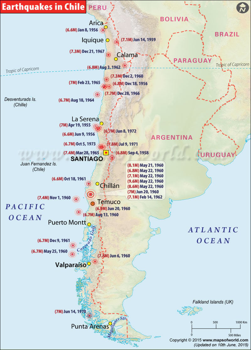 |
Map showing the epicenter for major Earthquakes in Chile from 1955 to 1975. |
Map showing recent Earthquake in Chile |
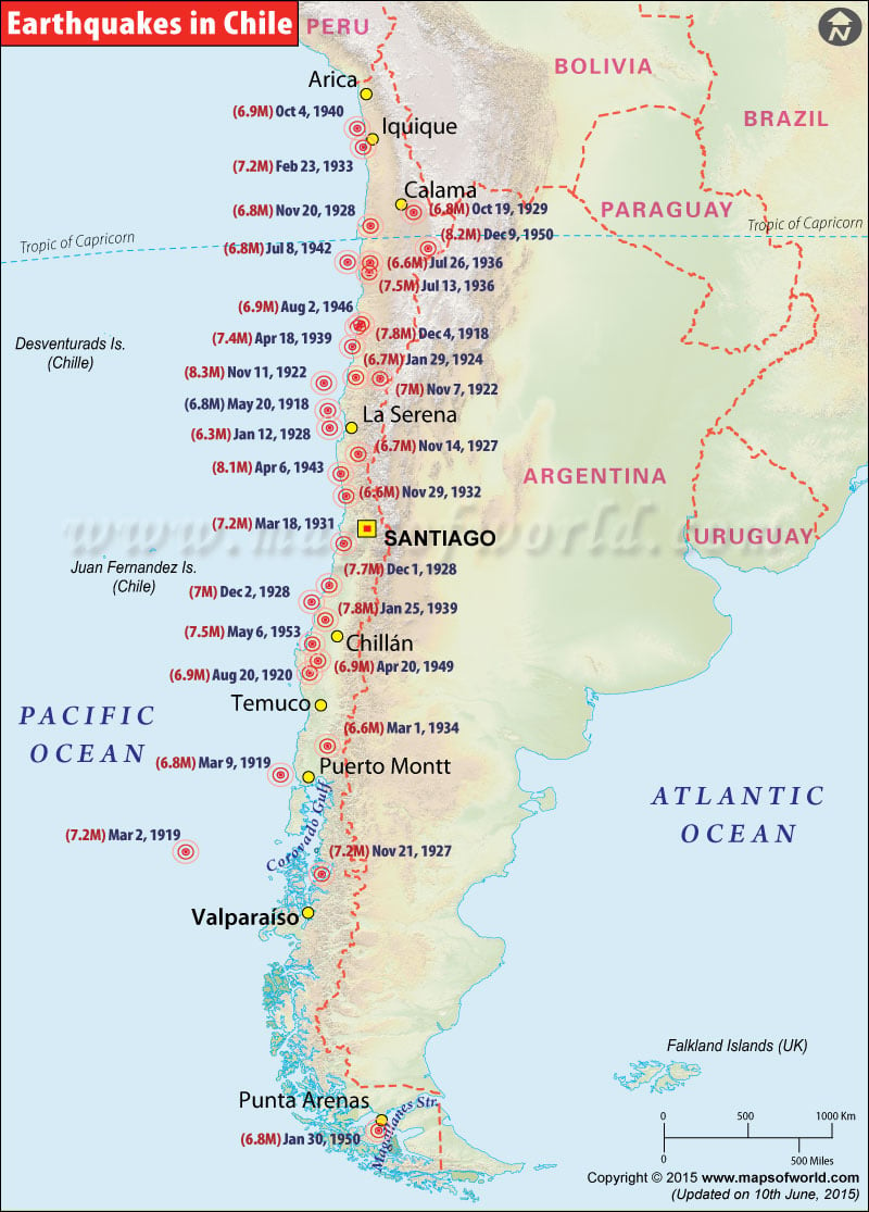 |
Map showing the epicenter for major Earthquakes in Chile from 1900 to 1955. |
Chile Earthquake Map
6.3 Magnitude Earthquake hits Mexico on October 10, 2017
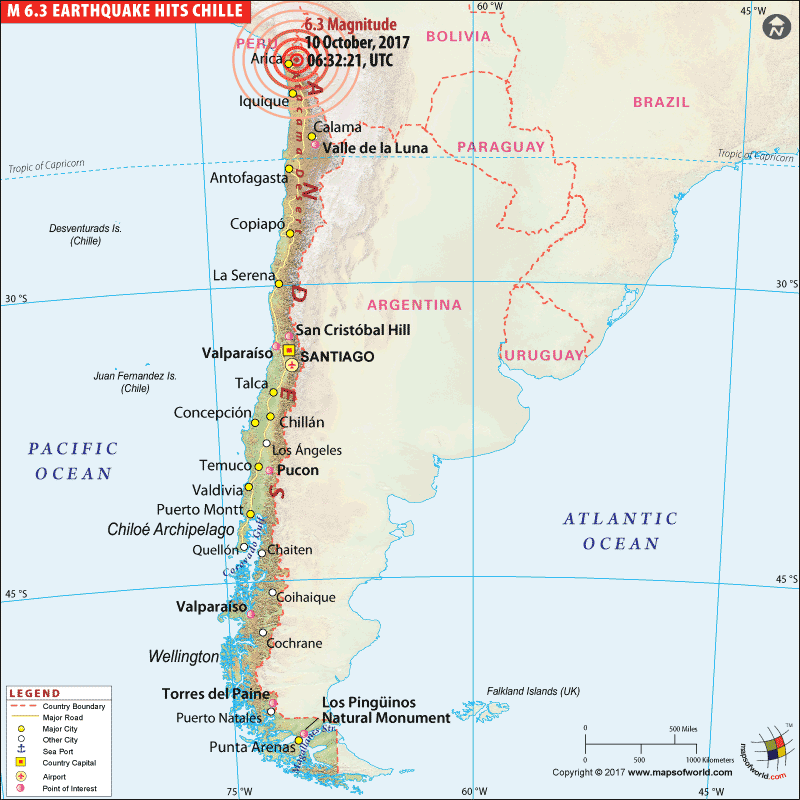
| Description :Map showing the location or epicenter of 6.3 Magnitude earthquake that hits Mexico on October 10, 2017. |
| Disclaimer |
6.3-Magnitude Earthquake Hits Mexico
6.9M Earthquake Strikes West Coast of Chile
Explore Map: Chile Map, Where is Chile?
M 6.2 Earthquake Strikes Chile
Powerful M7.7 Earthquake Hits Chile Coast
Another earthquake hits Chile
September 18, 2015 - A new earthquake of 6.3 magnitude earthquake struck Chile. The earthquake, which had a depth of 8 km, struck some 90 km northwest of Valparaiso, which is a port city on Chile’s coast. This earthquake came after an 8.3 magnitude quake hit off northern Chile on Wednesday.
Chile earthquake: Toll rises to 12
September 17, 2015 - The death toll in the earthquake that rocked Chile has risen to 12. Media reports quoted Interior Minister Jorge Burgos as saying that five people are listed as missing. Throughout the night, dozens of smaller aftershocks were felt in Chile. Seismologists said that though the earthquake would have created havoc in less prepared nations, but Chile’s heavy investment in structural reinforcement of buildings and constant improvement in its tsunami alert systems minimized the damages.
M8.3 earthquake west of Illapel, Chile
September 16, 2015 - M 8.3 earthquake west of Illapel, Chile, occurred as the result of thrust faulting on the interface between the Nazca and South America plates in Central Chile. At the latitude of this event, the Nazca plate is moving towards the east-northeast at a velocity of 74 mm/yr with respect to South America, and begins its subduction beneath the continent at the Peru-Chile Trench, 85 km to the west of the September 16 earthquake. The size, location, depth and mechanism of this event are all consistent with its occurrence on the megathrust interface in this region.
Chile Earthquake Timeline
[12:18 A.M. ET Thursday] - 15.3-foot wave hits Chile's coast following 8.3-magnitude earthquake, U.S. NWS Pacific Tsunami Warning Center says.
[10:53 p.m. ET Wednesday] - At least three people were killed when a powerful earthquake struck Chile on Wednesday, President Michelle Bachelet said
[10:24 p.m. ET Wednesday] - A powerful 8.3-magnitude earthquake struck off Chile's coast on Wednesday, triggering a tsunami alert and coastal evacuations
| PRELIMINARY EARTHQUAKE PARAMETERS | |
|---|---|
| MAGNITUDE | 8.3 |
| ORIGIN TIME | 2254 UTC SEP 16 2015 |
| COORDINATES | 31.5 SOUTH 72.0 WEST |
| DEPTH | 10 KM / 6 MILES |
| LOCATION | NEAR THE COAST OF CENTRAL CHILE |
M6.4 Earthquake - 76km NW of Talcahuano, Chile- June 20, 2015
Time
Nearby Cities
| Earthquakes in Chile | ||||||
|---|---|---|---|---|---|---|
| Date | Time | Latitude | Longitude | Depth | Magnitude | Location |
| Apr 3, 2014 | 02:43:13.11 | -20.5709 | -70.4931 | 22.4 | 7.7 | 53km SW of Iquique,Chile |
| Apr 1, 2014 | 23:57:58.79 | -19.8927 | -70.9455 | 28.42 | 6.9 | 91km WNW of Iquique,Chile |
| Apr 1, 2014 | 23:46:47.26 | -19.6097 | -70.7691 | 25 | 8.2 | 94km NW of Iquique,Chile |
| Mar 16, 2014 | 21:16:29.60 | -19.9807 | -70.7022 | 20 | 6.7 | 64km WNW of Iquique,Chile |
| Oct 31, 2013 | 23:03:59.72 | -30.2921 | -71.5215 | 27 | 6.6 | 41km SSW of Coquimbo,Chile |
| Jan 30, 2013 | 20:15:43.34 | -28.094 | -70.653 | 45 | 6.8 | 56km NNE of Vallenar,Chile |
| Apr 17, 2012 | 03:50:15.61 | -32.625 | -71.365 | 29 | 6.7 | Valparaiso,Chile |
| Mar 25, 2012 | 22:37:06.00 | -35.2 | -72.217 | 40.7 | 7.1 | Maule,Chile |
| Feb 14, 2011 | 03:40:09.92 | -35.38 | -72.834 | 21 | 6.7 | offshore Maule,Chile |
| Feb 11, 2011 | 20:05:30.91 | -36.422 | -72.96 | 26 | 6.9 | offshore Bio-Bio,Chile |
| Jan 2, 2011 | 20:20:17.78 | -38.355 | -73.326 | 24 | 7.2 | Araucania,Chile |
| Jul 14, 2010 | 08:32:21.49 | -38.067 | -73.31 | 22 | 6.6 | Bio-Bio,Chile |
| Mar 16, 2010 | 02:21:57.94 | -36.217 | -73.257 | 18 | 6.7 | offshore Bio-Bio,Chile |
| Mar 11, 2010 | 14:55:27.51 | -34.326 | -71.799 | 18 | 7 | Libertador General Bernardo O'Higgins,Chile |
| Mar 11, 2010 | 14:39:43.95 | -34.29 | -71.891 | 11 | 6.9 | Libertador General Bernardo O'Higgins,Chile |
| Mar 5, 2010 | 11:47:06.82 | -36.665 | -73.374 | 18 | 6.6 | offshore Bio-Bio,Chile |
| Feb 27, 2010 | 08:01:23.01 | -37.773 | -75.048 | 35 | 7.4 | off the coast of Bio-Bio,Chile |
| Feb 27, 2010 | 06:34:11.53 | -36.122 | -72.898 | 22.9 | 8.8 | offshore Bio-Bio,Chile |
| Dec 16, 2007 | 08:09:17.93 | -22.954 | -70.182 | 45 | 6.7 | Antofagasta,Chile |
| Nov 15, 2007 | 15:05:58.35 | -22.925 | -70.237 | 26 | 6.8 | Antofagasta,Chile |
| Nov 14, 2007 | 15:40:50.53 | -22.247 | -69.89 | 40 | 7.7 | Antofagasta,Chile |
| Apr 30, 2006 | 19:17:14.98 | -27.017 | -71.022 | 12 | 6.7 | offshore Atacama,Chile |
| Jun 13, 2005 | 22:44:33.90 | -19.987 | -69.197 | 115.6 | 7.8 | Tarapaca,Chile |
| May 3, 2004 | 04:36:50.04 | -37.695 | -73.406 | 21 | 6.6 | Bio-Bio,Chile |
| Jun 20, 2003 | 13:30:41.64 | -30.608 | -71.637 | 33 | 6.8 | Coquimbo,Chile |
| Jun 18, 2002 | 13:56:22.83 | -30.805 | -71.124 | 54 | 6.6 | Coquimbo,Chile |
| Apr 18, 2002 | 16:08:36.78 | -27.535 | -70.586 | 62 | 6.7 | Atacama,Chile |
| Apr 9, 2001 | 09:00:57.17 | -32.668 | -73.109 | 11 | 6.7 | off the coast of Valparaiso,Chile |
| Nov 30, 1999 | 04:01:53.22 | -18.901 | -69.171 | 128.1 | 6.6 | Tarapaca,Chile |
| Sep 3, 1998 | 17:37:58.24 | -29.45 | -71.715 | 27 | 6.6 | offshore Coquimbo,Chile |
| Apr 1, 1998 | 22:42:56.90 | -40.316 | -74.874 | 9 | 6.7 | offshore Los Lagos,Chile |
| Jan 30, 1998 | 12:16:08.69 | -23.913 | -70.207 | 42 | 7.1 | Antofagasta,Chile |
| Jan 12, 1998 | 10:14:07.63 | -30.985 | -71.41 | 34.8 | 6.6 | Coquimbo,Chile |
| Oct 15, 1997 | 01:03:33.46 | -30.933 | -71.22 | 58 | 7.1 | Coquimbo,Chile |
| Jul 6, 1997 | 09:54:00.76 | -30.058 | -71.872 | 19 | 6.8 | offshore Coquimbo,Chile |
| Apr 19, 1996 | 00:19:31.19 | -23.944 | -70.093 | 49.5 | 6.6 | Antofagasta,Chile |
| Nov 1, 1995 | 00:35:32.70 | -28.906 | -71.417 | 19.9 | 6.7 | Atacama,Chile |
| Jul 30, 1995 | 05:11:23.63 | -23.34 | -70.294 | 45.6 | 8 | Antofagasta,Chile |
| Jul 11, 1993 | 13:36:21.24 | -25.304 | -70.166 | 47.5 | 6.6 | Antofagasta,Chile |
| Mar 15, 1993 | 16:08:57.88 | -26.708 | -70.918 | 28.9 | 6.7 | offshore Atacama,Chile |
| Aug 14, 1988 | 17:53:09.75 | -27.26 | -71.092 | 32.5 | 6.7 | offshore Atacama,Chile |
| Feb 22, 1988 | 19:13:17.74 | -20.833 | -69.785 | 70.3 | 6.7 | Tarapaca,Chile |
| Feb 5, 1988 | 14:01:02.75 | -24.753 | -70.433 | 36.9 | 7.2 | Antofagasta,Chile |
| Jan 19, 1988 | 07:30:31.86 | -24.71 | -70.568 | 33 | 7 | Antofagasta,Chile |
| Aug 8, 1987 | 15:48:56.75 | -19.022 | -69.991 | 69.7 | 7.2 | Tarapaca,Chile |
| Mar 5, 1987 | 10:55:12.35 | -24.495 | -70.701 | 34.8 | 7 | near the coast of Antofagasta,Chile |
| Mar 5, 1987 | 09:17:05.28 | -24.388 | -70.161 | 62.3 | 7.6 | Antofagasta,Chile |
| Apr 9, 1985 | 01:56:59.48 | -34.131 | -71.618 | 37.8 | 7.2 | Libertador General Bernardo O'Higgins,Chile |
| Mar 19, 1985 | 04:01:08.00 | -33.198 | -71.653 | 42.2 | 6.7 | Valparaiso,Chile |
| Mar 17, 1985 | 10:41:38.48 | -32.633 | -71.551 | 33 | 6.7 | offshore Valparaiso,Chile |
| Mar 4, 1985 | 03:32:49.14 | -32.925 | -71.793 | 33 | 6.6 | offshore Valparaiso,Chile |
| Mar 4, 1985 | 00:32:21.87 | -33.207 | -71.663 | 33 | 7.4 | Valparaiso,Chile |
| Mar 3, 1985 | 22:47:07.28 | -33.135 | -71.871 | 33 | 8 | offshore Valparaiso,Chile |
| Oct 9, 1983 | 11:25:40.58 | -26.135 | -70.518 | 16.1 | 6.7 | Atacama,Chile |
| Oct 4, 1983 | 18:52:13.30 | -26.535 | -70.563 | 14.8 | 7.4 | Atacama,Chile |
| Feb 25, 1983 | 22:49:54.73 | -18.268 | -69.438 | 146 | 6.9 | Tarapaca,Chile |
| Nov 7, 1981 | 03:29:51.09 | -32.199 | -71.336 | 65.2 | 6.8 | Valparaiso,Chile |
| Oct 16, 1981 | 03:25:42.22 | -33.134 | -73.074 | 33 | 7.2 | off the coast of Valparaiso,Chile |
| Nov 30, 1976 | 00:40:57.80 | -20.52 | -68.919 | 82 | 6.5 | Tarapaca,Chile |
| May 10, 1975 | 14:27:38.70 | -38.183 | -73.232 | 6 | 7.7 | Bio-Bio,Chile |
| Mar 13, 1975 | 15:26:42.50 | -29.941 | -71.337 | 4 | 6.9 | offshore Coquimbo,Chile |
| Aug 18, 1974 | 10:44:12.80 | -38.453 | -73.431 | 36 | 7.1 | Araucania,Chile |
| Oct 5, 1973 | 05:47:51.10 | -32.518 | -71.478 | 33 | 6.7 | offshore Valparaiso,Chile |
| Jun 8, 1972 | 18:53:44.00 | -30.466 | -71.699 | 45 | 6.7 | offshore Coquimbo,Chile |
| Jul 9, 1971 | 03:03:20.00 | -32.601 | -71.076 | 60.3 | 7.8 | Valparaiso,Chile |
| Jun 14, 1970 | 00:00:11.00 | -52.028 | -74.07 | 15 | 7 | near the coast of Magallanes,Chile |
| Dec 21, 1967 | 02:25:26.00 | -21.865 | -69.939 | 45 | 7.3 | Antofagasta,Chile |
| Dec 28, 1966 | 08:18:07.00 | -25.494 | -70.55 | 25 | 7.7 | Antofagasta,Chile |
| Mar 28, 1965 | 16:33:16.00 | -32.522 | -71.233 | 70 | 7.4 | Valparaiso,Chile |
| Feb 23, 1965 | 22:11:47.00 | -25.633 | -70.679 | 35 | 7 | near the coast of Antofagasta,Chile |
| Aug 18, 1964 | 04:45:01.00 | -26.43 | -71.539 | 15 | 6.7 | offshore Atacama,Chile |
| Aug 3, 1962 | 08:56:20.00 | -23.167 | -67.914 | 124.8 | 6.8 | Antofagasta,Chile |
| Feb 14, 1962 | 06:36:05.00 | -37.845 | -72.885 | 30 | 7.1 | Araucania,Chile |
| Dec 9, 1961 | 11:18:11.00 | -43.789 | -75.84 | 25 | 6.7 | off the coast of Los Lagos,Chile |
| Oct 18, 1961 | 16:51:57.00 | -36.738 | -73.238 | 20 | 6.6 | offshore Bio-Bio,Chile |
| Dec 2, 1960 | 09:10:48.00 | -24.732 | -70.297 | 35 | 7.3 | Antofagasta,Chile |
| Nov 1, 1960 | 08:45:59.00 | -38.467 | -75.031 | 20 | 7.4 | off the coast of Araucania,Chile |
| Aug 13, 1960 | 14:14:56.00 | -39.964 | -74.783 | 25 | 6.7 | offshore Los Lagos,Chile |
| Jun 20, 1960 | 12:59:46.00 | -39.071 | -72.813 | 25 | 6.9 | Araucania,Chile |
| Jun 20, 1960 | 02:01:14.00 | -38.154 | -72.917 | 25 | 7 | Araucania,Chile |
| Jun 6, 1960 | 05:55:48.00 | -45.785 | -72.889 | 15 | 7.8 | Aisen,Chile |
| May 25, 1960 | 08:34:42.00 | -44.808 | -75.985 | 20 | 6.7 | off the coast of Aisen,Chile |
| May 22, 1960 | 19:11:20.00 | -38.143 | -73.407 | 25 | 9.6 | Bio-Bio,Chile |
| May 22, 1960 | 18:56:02.00 | -38.061 | -73.039 | 25 | 8.6 | Araucania,Chile |
| May 22, 1960 | 10:32:47.00 | -37.86 | -73.149 | 25 | 6.8 | Bio-Bio,Chile |
| May 22, 1960 | 10:30:44.00 | -37.775 | -73.017 | 25 | 7.1 | Bio-Bio,Chile |
| May 21, 1960 | 10:02:57.00 | -37.824 | -73.353 | 25 | 8.1 | Bio-Bio,Chile |
| Jun 14, 1959 | 00:12:06.00 | -20.407 | -68.862 | 109.2 | 7.1 | Tarapaca,Chile |
| Sep 4, 1958 | 21:51:16.00 | -33.832 | -69.958 | 15 | 6.8 | Region Metropolitana,Chile |
| Dec 18, 1956 | 02:31:11.00 | -25.552 | -70.036 | 44.9 | 6.8 | Antofagasta,Chile |
| Jun 9, 1956 | 10:08:29.00 | -30.332 | -71.474 | 23.5 | 6.6 | Coquimbo,Chile |
| Jan 8, 1956 | 20:54:23.00 | -18.966 | -70.507 | 51.5 | 6.6 | near the coast of Tarapaca,Chile |
| Apr 19, 1955 | 20:24:10.00 | -30.128 | -71.935 | 15 | 7 | offshore Coquimbo,Chile |
| May 6, 1953 | 17:16:48.00 | -37.093 | -72.866 | 66 | 7.5 | Bio-Bio,Chile |
| Dec 9, 1950 | 21:38:51.00 | -23.977 | -67.912 | 113.9 | 8.2 | Antofagasta,Chile |
| Jan 30, 1950 | 00:56:35.00 | -53.472 | -71.073 | 15 | 6.8 | Magallanes y Antartica,Chilena,Chile |
| Apr 20, 1949 | 03:29:10.00 | -37.665 | -72.676 | 57.7 | 6.9 | Araucania,Chile |
| Aug 2, 1946 | 19:18:52.00 | -26.432 | -70.472 | 39.2 | 6.9 | Atacama,Chile |
| Apr 6, 1943 | 16:07:17.00 | -31.432 | -71.475 | 35 | 8.1 | Coquimbo,Chile |
| Jul 8, 1942 | 06:55:44.00 | -24.391 | -70.061 | 35 | 6.8 | Antofagasta,Chile |
| Oct 4, 1940 | 07:55:02.00 | -19.86 | -70.343 | 35 | 6.9 | near the coast of Tarapaca,Chile |
| Apr 18, 1939 | 06:22:44.00 | -27.182 | -70.842 | 35 | 7.4 | Atacama,Chile |
| Jan 25, 1939 | 03:32:15.00 | -36.305 | -72.315 | 35 | 7.8 | Bio-Bio,Chile |
| Jul 26, 1936 | 07:36:58.00 | -24.341 | -70.889 | 35 | 6.6 | near the coast of Antofagasta,Chile |
| Jul 13, 1936 | 11:12:18.00 | -24.72 | -70.11 | 35 | 7.5 | Antofagasta,Chile |
| Mar 1, 1934 | 21:45:15.00 | -40.535 | -72.459 | 15 | 6.6 | Los Lagos,Chile |
| Feb 23, 1933 | 08:09:19.00 | -20.5 | -70.157 | 35 | 7.2 | Tarapaca,Chile |
| Nov 29, 1932 | 11:11:00.00 | -32.192 | -71.305 | 35 | 6.6 | Valparaiso,Chile |
| Mar 18, 1931 | 08:02:25.00 | -33.778 | -71.478 | 35 | 7.2 | Valparaiso,Chile |
| Oct 19, 1929 | 10:12:54.00 | -22.751 | -68.403 | 65 | 6.8 | Antofagasta,Chile |
| Dec 2, 1928 | 04:20:25.00 | -35.685 | -72.812 | 30 | 7 | offshore Maule,Chile |
| Dec 1, 1928 | 04:06:17.00 | -35.155 | -72.105 | 35 | 7.7 | Maule,Chile |
| Nov 20, 1928 | 20:35:12.00 | -23.152 | -69.997 | 45 | 6.8 | Antofagasta,Chile |
| Jan 12, 1928 | 13:06:43.00 | -29.879 | -71.819 | 30 | 6.3 | offshore Coquimbo,Chile |
| Nov 21, 1927 | 23:12:32.00 | -44.816 | -72.926 | 15 | 7.2 | Aisen,Chile |
| Nov 14, 1927 | 07:19:30.00 | -30.798 | -70.782 | 50 | 6.7 | Coquimbo,Chile |
| Jan 29, 1924 | 01:54:58.00 | -28.222 | -70.755 | 45 | 6.7 | Atacama,Chile |
| Nov 11, 1922 | 04:32:51.00 | -28.293 | -69.852 | 70 | 8.3 | Atacama,Chile |
| Nov 7, 1922 | 23:00:17.00 | -28.365 | -71.96 | 25 | 7 | offshore Atacama,Chile |
| Aug 20, 1920 | 16:15:41.00 | -38.063 | -73.017 | 15 | 6.9 | Araucania,Chile |
| Mar 9, 1919 | 03:16:58.00 | -41.421 | -74.368 | 15 | 6.8 | offshore Los Lagos,Chile |
| Mar 2, 1919 | 03:26:35.00 | -43.8 | -78.319 | 15 | 7.2 | off the coast of Los Lagos,Chile |
| Dec 4, 1918 | 11:47:50.00 | -26.538 | -70.608 | 40 | 7.8 | Atacama,Chile |
| May 20, 1918 | 17:55:07.00 | -29.292 | -71.857 | 20 | 6.8 | offshore Coquimbo,Chile |

