logo


Zambia Latitude and Longitude Map

Zambia's latitude and longitude is 15° 0' S and 30° 0 ' E. Below is the map of Zambia showing major towns, roads, airports with latitudes and longitudes plotted on it.
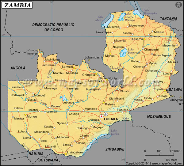
Zambia Latitude and Longitude Map
Democratic Republic of Congo Latitude and Longitude Map Tanzania Latitude and Longitude Map Malawi Latitude and Longitude Map Mozambique Latitude and Longitude Map Zimbabwe Latitude and Longitude Map Botswana Latitude and Longitude Map Namibia Latitude and Longitude Map Angola Latitude and Longitude Map
Description : Find Zambia latitude and longitude map showing comprehensive details including cities, roads, towns, airports and much more. Disclaimer
×

Disclaimer  :  All efforts have been made to make this image accurate. However MapSherpa, Inc, its directors and employees do not own any responsibility for the correctness or authenticity of the same.

The Republic of Zambia, lies within the latitude and longitude of 15 00 S and 30 00 E. The country of Zambia lies in Southern Africa in the east of Angola. The latitude and longitude of Zambia covers a total area of 752,614 square kilometer. The climatic conditions of Zambia are tropical in nature. The rainy season in the country ranges from November to April. Zambia also experiences periodic drought and tropical storms during October to April. The terrain of Zambia is characterized by high plateau along with some hills and mountains. The highest point in Zambia is the Mafinga Hills that is at 2301m. The lowest point is the Zambezi River. The country of Zambia is landlocked and the Zambezi River forms a natural boundary with Zimbabwe.

Lusaka, the capital of the country of Zambia, lies within the latitude and longitude of 15 25 S and 28 17 E.
Locations Latitude Longitude
Abercorn / Mabala08°46'S31°24'E
Bangweulu, L.11°00'S30°00'E
Bangweulu Swamp11°20'S30°15'E
Barotseland15°00'S24°00'E
Batoka16°5'S27°15'E
Bowwood17°05'S26°20'E
Broken Hill / Kabwe14°30'S28°29'E
Busango Swamp14°15'S25°45'E
Central14°25'S28°50'E
Chadiza14°45'S32°27'E
Chambeshi11°53'S29°48'E
Chasefu11°55'S33°08'E
Chiengi08°45'S29°10'E
Chilanga15°33'S28°16'E
Chililabombwe12°18'S27°43'E
Chilubi11°05'S29°58'E
Chilubula10°14'S30°51'E
Chimpembe09°31'S29°33'E
Chingola12°31'S27°53'E
Chinsali10°30'S32°02'E
Chipata13°38'S32°28'E
Chisamba14°55'S28°20'E
Chisimba Falls10°12'S30°56'E
Chizera13°10'S25°00'E
Choma16°48'S26°59'E
Chunga15°00'S26°02'E
Copperbelt13°15'S27°30'E
Itezhi Tezhi, L.15°30'S25°30'E
Johnston Falls / Mambilima Falls10°31'S28°45'E
Kabompo13°36'S24°14'E
Kabompo14°10'S23°11'E
Kabwe14°30'S28°29'E
Kachebera13°50'S32°50'E
Kafinda12°32'S30°20'E
Kafue15°46'S28°09'E
Kafue15°30'S29°00'E
Kafue Flats15°40'S27°25'E
Kafulwe09°00'S29°01'E
Kalomo17°00'S26°30'E
Kalulushi12°50'S28°03'E
Kamapanda12°05'S24°00'E
Kambole08°47'S30°48'E
Kampolombo, L.11°37'S29°42'E
Kapiri Mposhi13°59'S28°43'E
Kariba Gorge16°30'S28°50'E
Kasama10°16'S31°09'E
Kasempa13°30'S25°44'E
Kasewa14°28'S28°53'E
Kataba16°05'S25°10'E
Katima Mulilo17°28'S24°13'E
Kawambwa09°48'S29°03'E
Kayomba13°11'S24°02'E
Kitwe12°54'S28°13'E
Liuwa Plain14°20'S22°30'E
Luampa15°04'S24°20'E
Luangwa15°35'S30°16'E
Luangwa Valley13°30'S31°30'E
Luanshya13°03'S28°28'E
Luspula 11°0'S29°0'E
Lubungu14°35'S26°24'E
Lukanga Swamp14°30'S27°40'E
Lundazi12°20'S33°007'E
Lunga 14°34'S26°25'E
Lunsemfwa14°54'S30°12'E
Lunsemfwa Falls14°30'S29°06'E
Lusaka15°25'S28°16'E
MaaMba17°17'S26°28'E
Magoye16°01'S27°30'E
Mambilima Falls10°31'S28°45'E
Mansa11°13'S28°55'E
Mazabuka15°52'S27°44'E
Mbala08°46'S31°24'E
Mbesuma10°0'S32°02'E
Mkushi14°25'S29°15'E
Mkushi River13°32'S29°45'E
Mongu15°16'S23°12'E
Monze16°17'S27°29'E
Mpika11°51'S31°25'E
Mpulungu08°51'S31°05'E
Msoro 13°35'S31°50'E
MuchingaMts. 11°30'S31°30'E
Mufulira12°32'S28°15'E
Mukwela17°0'S26°40'E
Mulobezi16°45'S25°07'E
Mulungushi Dam.14°48'S28°48'E
Mumbwa15°0'S27°0'E
Munyama16°05'S28°31'E
Musofu13°30'S29°0'E
Mutanda12°24'S26°13'E
Mwandi 17°30'N24°51'E
Mwanza16°58'S24°28'E
Mweru L.09°0'S28°40'E
Mwinilunga11°43'S24°25'E
Namwala15°44'S26°30'E
Nanjeko15°31'S23°30'E
Nchanga12°30'S27°49'E
Ndola13°0'S28°34'E
Njanji14°25'S31°46'E
Nkana12°50'S28°08'E
North Western 13°30'S25°30'E
Northern10°30'S31°0'E
Nsomba10°45'S29°51'E
Pemba 16°30'S27°28'E
Petauke14°14'S31°20'E
Rosa9°33'S31°15'E
Rufunsa15°4'N29°34'E
Samfya 11°22'S29°31'E
Senanga16°7'S23°16'E
Senga Hill9°19'S31°11'E
Serenje13°14'S30°15'E
Sesheke17°29'S24°13'E
Sinde 17°28'S25°51'E
Solwezi 12°11'S26°21'E
Southern1620'S26°20'E
Tara 16°58'S26°45'E
Walamba13330'S28°42'E
West Lunga13°6'S24°39'E
Western15°0'S24°4'E
Zambezi 13°30'S23°15'E
Zimba17°20'S26°11'E

Last Updated on: September 18th, 2017