logo


eSwatini (Swaziland) Latitude and Longitude Map

Eswatini(Swaziland)'s latitude and longitude is 26° 30 S and 31° 30 E. Below is the map of eSwatini (Swaziland) showing major towns, roads, airports with latitudes and longitudes plotted on it.
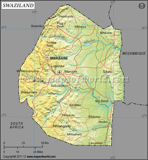
eSwatini (Swaziland) Latitude and Longitude Map
South Africa Latitude and Longitude Map Mozambique Latitude and Longitude Map
Description : Find eSwatini (Swaziland) latitude and longitude map showing comprehensive details including cities, roads, towns, airports and much more. Disclaimer
×

Disclaimer  :  All efforts have been made to make this image accurate. However MapSherpa, Inc, its directors and employees do not own any responsibility for the correctness or authenticity of the same.


The small Swazi community of South Africa which makes up today's eSwatini (Swaziland) lies within the latitude and longitude denominations of 26°30 S and 31°30 E respectively.
Swaziland' latitude and longitude denominations positions it in the extreme south of the African continent and gives it a position between South Africa and the Mozambique. Swaziland' latitude and longitude co-ordinates had long made the country a part of South Africa and, hence, the country had to experience British rule. Today, however, the country occupies a total area of exactly 17,363 sq km. The latitude and longitude co-ordinates of Swaziland' capital, Mbabane, are respectively 26°18 S and 31°06 E.

The latitude and longitude denominations of eSwatini (Swaziland) provides it with a climate that is tropical for most part of the year but sometimes the temperatures border towards a temperate kind of climate.

Locations Latitude Longitude
Big Bend26°50'S31°58'E
Lavumisa27°20'S31°55'E
Mankayane26°40'S31°04'E
Manzini26°30'S31°25'E
Mbabane26°18'S31°06'E
Siteki 26°32'S31°58'E

Last Updated on: December 28th, 2016