Senegal Latitude and Longitude Map
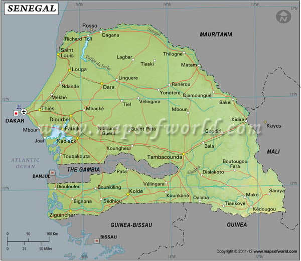
Senegal's latitude and longitude is 14° 00' N and 14° 00' W . Below is the map of Senegal showing major towns, roads, airports with latitudes and longitudes plotted on it.
Search For Latitude & Longitude Map
Or
Latitude
Longitude
Or
Area
* Put South & West values with minus ( - ) sign.
|
|

|
| Description: Find Senegal latitude and longitude map showing comprehensive details including cities, roads, towns, airports and much more. | Disclaimer |
The latitude and longitude of Senegal is 14º 00' N and 14º 00' W respectively. It is located in western Africa and lies between Mauritania and Guinea-Bissau.
| Locations | Latitude | Longitude |
| Bakel | 14°56'N | 12°20'W |
| Dagana | 16°30'N | 15°35'W |
| Dakar | 14°34'N | 17°29'W |
| Kaolack | 14°05'N | 16°08'W |
| Linguere | 15°25'N | 15°05'W |
| Louga | 15°45'N | 16°05'W |
| Matam | 15°34'N | 19°17'W |
| Mbour | 14°22'N | 16°54'W |
| St. Louis | 16°8'N | 16°27'W |
| Sedhiou | 12°44'N | 15°30'W |
| Tivaouane | 14°56'N | 16°45'W |
| Vert C. | 14°45'N | 17°30'W |
Last Updated on: July 18, 2020


