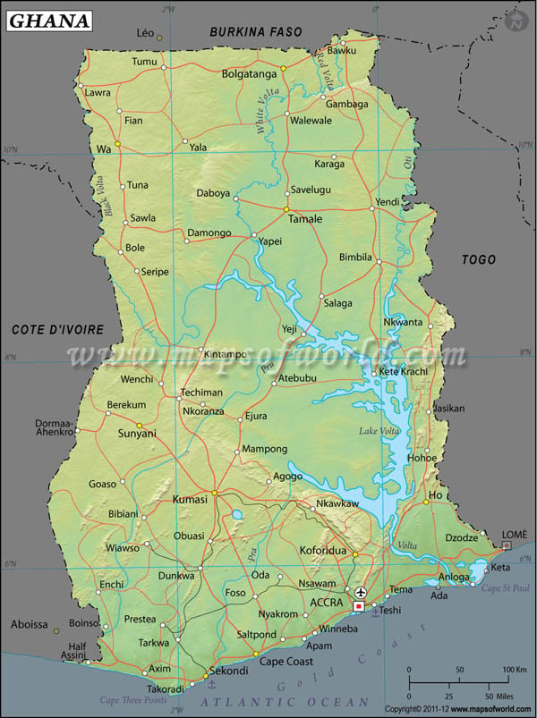
The Republic of Ghana in Western Africa is located on the latitude and longitude of 8°00'N and 2°00'W respectively.
Ghana was formed in 1957 out of a merger of the Gold Coast and Togoland trust territories. The capital of Ghana is Accra and has a geographic location of 5°33'N latitude and 0°15'W longitude . The sub-Saharan African nation of Ghana belongs to the Commonwealth of Nations.
The latitude and longitude of Ghana span across an area of 239,460 sq km. This geographic location of Ghana ensures a unique climatic combination across the country. The coastal regions have a dry tropical type of climate. The southwestern regions are warm and humid through most of the year while the northern areas are dry and warm. Ghana's terrain is peculiar as in it has mostly low lying areas with a plateau region in the central landmass. The tallest peak is Mount Afadjato with a height of 880 meter.
Ghana has a population currently estimated at 22,931,299 which is liable to dip due to the high mortality rate because of the rampant AIDS infection in the country.
Latitude and Longitude of Ghana |
|---|
| Location | Latitude | Longitude |
|---|
| Accra | 05°35'N | 00°06'W |
| Asamankese | 05°50'N | 00°40'W |
| Axim | 04°51'N | 02°15'W |
| Bawku | 11°03'N | 00°19'W |
| Berekum | 07°29'N | 02°34'W |
| Cape Coast | 05°05'N | 01°15'W |
| Koforidua | 06°03'N | 00°17'W |
| Kumasi | 06°41'N | 01°28'W |
| Obuasi | 06°17'N | 01°40'W |
| Salaga | 8°31'N | 0°31'W |
| Savelugu | 9°38'N | 0°54'W |
| Sekolndi Taoradi | 4°58'N | 1°45'W |
| Tamale | 9°22'N | 0°50'W |
| Tema | 5°41'N | 0°0'W |
| Three Points C. | 4°42'N | 2°6'W |
| Tumu | 10°56'N | 1°56'W |
| Volta | 5°46'N | 0°41'E |
| Volta L. | 7°30'N | 0°0'W |
| Wenchi | 7°46'N | 2°8'W |
Last Updated on: November 14th, 2017


