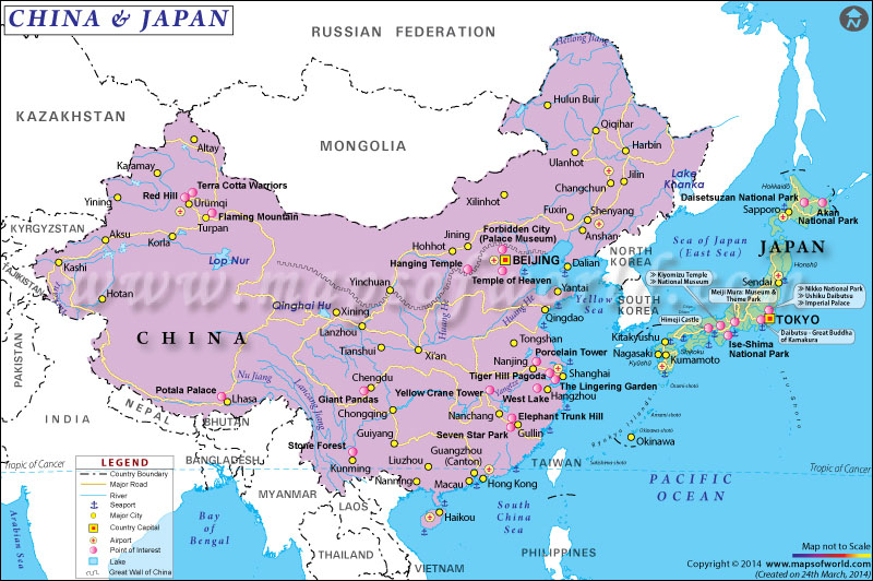
The map of China and Japan depicts the location of the two Asian nations. The map shows the international boundary, major cities in the two countries and important infrastructure.
China, the world's most populous country, is also the fourth largest in the world by total area. Covering a total area of 3,705,407 square miles, the country comprises a population of 1,403,500,365 inhabitants, according to the 2016 estimate.
Beijing is the capital of China, while Shanghai is its largest city. China borders 14 countries which include Vietnam, Laos, Myanmar, Nepal, Bhutan, India, Afghanistan, Pakistan, Russia, Mongolia, Tajikistan, North Korea, Kazakhstan, and Kyrgyzstan. The huge nation shares its maritime border with Japan, the Philippines, South Korea, and Vietnam. China has the second largest economy in the world by nominal GDP as of 2016. China has numerous modern cities such as Chengdu, Nanjing, Guangzhou, Macau, Hong Kong, Shenzhen, etc. Highlighted on the map are airports, rail lines, sea ports, points of etc etc. The Great Wall of China is also clearly demarcated on the map.
Japan is an island nation and covers an area of 145,936 square miles. The country comprises a population of 126,740,000 inhabitants. Tokyo is the capital of the country as well as its largest city. Japan shares its maritime borders with China, North Korea, South Korea, Russia, Taiwan, the Philippines, and Northern Mariana Islands. The nation has a strong economy and is the third largest economy in the world by nominal GDP. It is also the fourth largest economy by purchasing power parity. Apart from Tokyo, other prominent cities in the country are Kyoto, Osaka, Yokohama, Nagoya, Kobe, Fukuoka, Sapporo, etc.
Last Updated on: February 21, 2020


