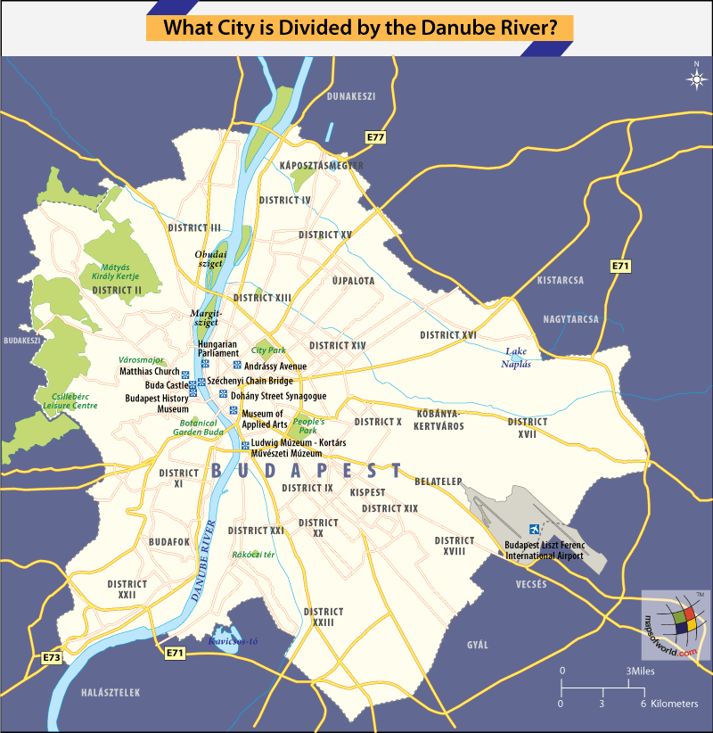

Map Highlighting River Danube Dividing Budapest
The city of Budapest is divided by River Danube.
Budapest is the twin city capital of Hungary and comprises of Buda on one side of the Danube River and Pest on the other.
Budapest has eight prominent bridges over the Danube River; Mégyeri Bridge, Chain Bridge, Elizabeth Bridge, Arpad Bridge, Liberty Bridge, Petofi Bridge, Margaret Bridge, and Lagymanyosi Bridge.
Budapest
The city of Budapest is located at 47°29’33’N and 19°03’05’E, at an elevation of 364 feet. The city is divided into 22 boroughs or districts and is spread over 202.8 square miles, making it the seventh largest city in Europe. The Budapest Metropolitan area covers 2,944 square miles with a population of 1,741,041.
The three cities, Buda, Obuda and Pest, were independent for centuries and were united as one city – Budapest, only in 1873. The first step to unification came when the famous Chain Bridge was built over the Danube connecting Buda-Obuda with Pest, in 1849.
From then on, Budapest saw a surge in development activity that made it one of the most dynamic cities of the late 19th and early 20th century. Today, the city stands as a wonderful blend of heritage and modernity, and attracts over 2.7 million tourists every year.
Budapest is defined by its Baroque period architecture, with the Buda Castle Quarter, a UNESCO World Heritage site, standing out as a fine example. The other UNESCO Heritage sites are the Banks of the Danube, Andrássy Avenue, Heroes’ Square and the Millennium Underground Railway, the second oldest underground metro rail network in the world.
Other popular landmarks in the city include the 11th century Matthias Church, Hungarian Parliament Building – the largest building in Hungary, Széchenyi Chain Bridge, Fisherman’s Bastion, Opera House, Memento Park – Statue Park, Heroes Square, Andrássy Avenue, St. Stephen’s Basilica, Széchenyi Thermal Bath, Margaret Island, Dohany Street Synagogue.
Danube River
The Danube River is the second longest river in Europe after the Volga and flows through four capital cities – Vienna, Austria; Budapest, Hungary; Bratislava, Slovakia; and Belgrade, Serbia. It passes through 10 countries – Germany, Austria, Slovakia, Hungary, Croatia, Serbia, Bulgaria, Romania, Moldova, and Ukraine, before joining the Black Sea. The river draws its water from 19 nation states along the way and drains approximately 315,000 square miles.
The river originates at the confluence of the Breg and Brigach rivers in Donaueschingen town, in the Black Forest area of Germany and flows for 1,770 miles to its mouth on the Black Sea.
The river is an important waterway for large, medium and small ships that transport commercial cargo. Besides transportation, the Danube sustains industries like tourism and fishing for cities along its banks.
The Republic of Madagascar is an island country located in the Indian Ocean, off the…
The Euro is the official currency of the European Union. It is, however, not incumbent…
There are many countries or regions that are partially recognized by the UN, have disputes…
The Alaska Statehood Act was signed into law by President Dwight D. Eisenhower in 1958,…
The name Persia may, however, only be used to refer to Iran in some contexts.…
Hawaii is an Island State in the US. It is one of the 50 states…