

US Map highlighting Texas which Experiences the Maximum Tornadoes
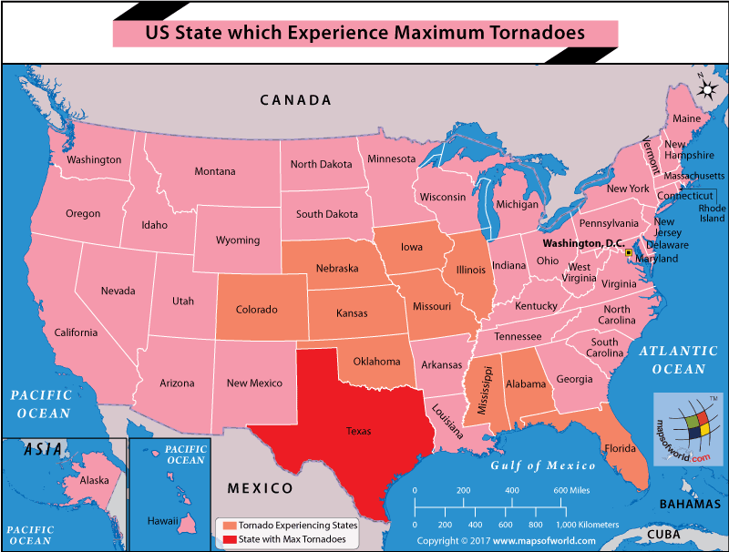
The United States witnesses more tornadoes than any other country in the world. On average, about 1,224 tornadoes are reported in the US each year. This is about four times the number of tornadoes that touch down in the entire continent of Europe through the course of a year. While every state of the US is vulnerable to tornadoes, the states to the south and the east (of the Rockies) are more prone than the others. Going by the data for 1991-2015, Texas, is the state that ranks right on top with an average of 146.7 tornadoes. It is followed by Kansas, Oklahoma, Florida, Nebraska, Illinois, Colorado, Iowa, Alabama, Missouri, and Mississippi.
A tornado is a large violently rotating funnel-shaped column of air. Tornadoes are violent forces of nature and wreak havoc on their path. With wind speeds going up to 300 miles per hour, tornadoes uproot trees, lift vehicles and buildings and nearly everything in their way. According to the National Centers for Environmental Information (USA), “In the United States, there are two regions with a disproportionately high frequency of tornadoes. Florida is one and ‘Tornado Alley’ in the south-central United States is the other”.
This Tornado Alley is an informal name given to the central and southern plains of the US, stretching from the Canadian border in the north to Texas and covering parts of Kansas and Oklahoma. Another region that is very prone to tornadoes is the Dixie Alley that includes parts of Alabama and Mississippi. While the state of Florida is also likely to experience tornadoes, these rarely gather much fury like the tornadoes in other parts of the country.
In 2011, a total of 362 tornadoes raged across the United States and some parts of Canada as well. Four of these tornadoes escalated to EF – 5 (highest level of severity as per the Enhanced Fujita scale). This is called the 2011 Super Outbreak and is considered one of the costliest and most destructive outbreaks in history. Tornadoes became a daily occurrence during April. Arkansas, Georgia, Tennessee, and Virginia were severely affected, and these tornadoes caused large-scale destruction.
Related Maps:
The Republic of Madagascar is an island country located in the Indian Ocean, off the…
The Euro is the official currency of the European Union. It is, however, not incumbent…
There are many countries or regions that are partially recognized by the UN, have disputes…
The Alaska Statehood Act was signed into law by President Dwight D. Eisenhower in 1958,…
The name Persia may, however, only be used to refer to Iran in some contexts.…
Hawaii is an Island State in the US. It is one of the 50 states…


