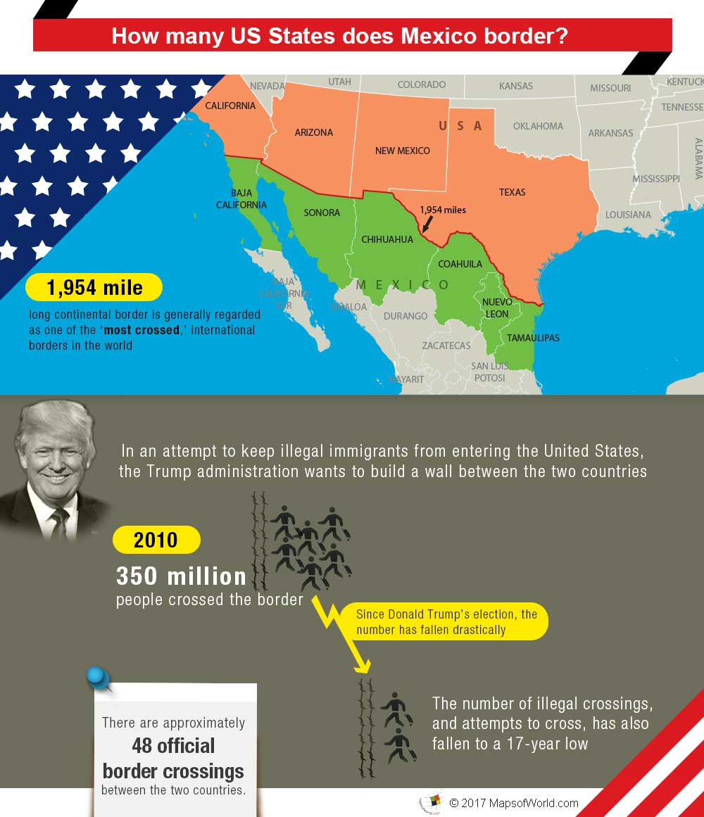
What States Border Mexico?
The border between the United States and Mexico is the longest international border between two countries that still needs to be fully militarized. It stretches over 1,950 miles, from the Pacific Ocean in the west to the Gulf of Mexico in the east. In this article, we will learn what states border Mexico, history of US Mexico border, and more.
States That Border Mexico
Four US States are bordering Mexico and they are:
-
California
California has a 140-mile border with Mexico. It begins at the Pacific Ocean and ends at the Colorado River. The busy city of San Diego is next to Tijuana, and Baja California, and together they create one of the world’s busiest border crossings.
-
Arizona
Arizona has a 372-mile border with Mexico that passes through rough desert areas. Important border towns along this border include Nogales, Douglas, and San Luis. Nogales is a major crossing point with lots of trade and daily crossings for work, shopping, and family visits. The Sonoran Desert covers much of this border area.
-
New Mexico
New Mexico has a 179-mile border with Mexico. This border is mostly in rural areas with few people living there. Santa Teresa is the main crossing point. The region is filled with large desert landscapes. Even though it’s a quiet area, it plays an important role in trade and cultural exchange, helping the local economy with agriculture and business with Mexico.
-
Texas
Texas has the longest border with Mexico, running about 1,254 miles along the Rio Grande. This border includes big cities like El Paso, Laredo, McAllen, and Brownsville, which are key for trade and interaction between the two countries. Texas has a strong connection with Mexico. Cities like El Paso and San Antonio are lively centers of Mexican American culture.
History of the US-Mexico Border
The US-Mexico border’s history is a story of shifting landscapes, politics, and migration that goes back to the early 1800s. It was first established in 1848 after the Mexican-American War through the Treaty of Guadalupe Hidalgo. This treaty gave a large part of Mexico’s northern land to the United States, which includes today’s California, Arizona, New Mexico, and Texas. In 1853, the Gadsden Purchase added another strip of land to the U.S. to help build a southern railroad. Over time, the border changed from being a mostly open area to a more controlled and monitored one, reflecting the political, social, and economic changes between the two countries.
Interesting Facts about US Mexico Border
- There are unique binational parks like Friendship Park, located at the border between San Diego and Tijuana, where families separated by the border can meet.
- Border towns often celebrate festivals that highlight the blend of American and Mexican cultures, including music, dance, and culinary traditions.
- The construction of border barriers has affected wildlife migration and natural habitats. Conservationists work to mitigate these impacts, especially in ecologically sensitive areas like the Sonoran Desert.
- Many communities along the border are bilingual, with residents often fluent in both English and Spanish, reflecting the cultural blend of the region.
- There are 48 official border crossings between the U.S. and Mexico, with San Ysidro Port of Entry in California being the busiest land border crossing in the Western Hemisphere.
- The border region provides a vital habitat corridor for endangered species like jaguars and ocelots.
- Over 350 million legal crossings happen annually, making it the most frequently crossed international border globally.
- Bilateral trade between the US and Mexico is massive, exceeding $650 million daily, with two-thirds of that happening in Texas.
Related Links

