

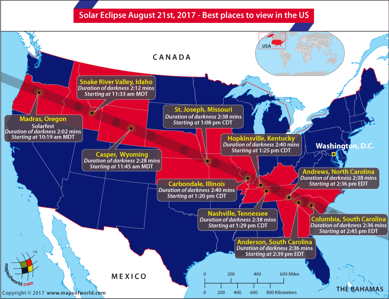
US Map showing the places from where the solar eclipse of 2017 will be best viewed
Later this month, on August 21, 2017, the Great American Eclipse will make its way across the United States from the Pacific to the Atlantic Coast. It has been almost a century since the last time a total solar eclipse made its way on a coast to coast journey across the US in 1918. The last time a total solar eclipse was visible from anywhere in the contiguous United States was in 1979. The total solar eclipse is a rare and stunning phenomenon. Not taking the necessary precautions could, however, turn it into a dangerous and potentially traumatizing experience.
Here are a few dos and don’ts that will make viewing the eclipse a safe and memorable experience:
Related Maps:
The Republic of Madagascar is an island country located in the Indian Ocean, off the…
The Euro is the official currency of the European Union. It is, however, not incumbent…
There are many countries or regions that are partially recognized by the UN, have disputes…
The Alaska Statehood Act was signed into law by President Dwight D. Eisenhower in 1958,…
The name Persia may, however, only be used to refer to Iran in some contexts.…
Hawaii is an Island State in the US. It is one of the 50 states…


