What are the Key Facts of Haiti?

|
Official Name |
Republic of Haiti |
|
Continent |
North America (Caribbean) |
|
Capital |
Port-au-Prince |
|
Largest City |
Port-au-Prince |
|
Coordinates |
19.000000, -72.416667 |
|
Area |
10,710 sq. mi (27,750 sq. km) |
|
Land Boundaries |
234 mi ( 376 km) |
|
Coastline |
1,100 mi ( 1,771 km) |
|
Currency |
Haitian gourde (G) (HTG) |
|
Neighboring Countries |
Dominican Republic, Maritime Neighbors: Cuba, Jamaica |
|
Population |
11,123,178 (2018 est.) |
|
Official Languages |
French, Haitian Creole |
|
Major Religion |
Christianity |
|
National Day |
1 January (Independence Day) |
|
National Anthem |
“La Dessalinienne” |
|
Form of Government |
Unitary semi-presidential republic |
|
President |
Jovenel Moïse |
|
Prime Minister |
Jean-Michel Lapin |
|
GDP per capita (PPP) |
$ 1,863.3 (World Bank, 2018) |
|
GDP per capita (nominal) |
$ 868.3 (World Bank, 2018) |
|
HDI |
0.498 (2017), Rank: 168 |
|
Literacy Rate (%) |
61.69 (UNESCO, 2016) |
|
Space Agency |
NA |
|
Military Expenditure Ranking |
148 (SIPRI, 2017) |
|
No. of Olympic Medals |
2 (as of 2018) |
|
Driving Side |
right |
|
Calling Code |
+509 |
|
Time Zone |
UTC−5 (EST), Summer (DST): UTC−4 (EDT) |
|
Internet TLD |
.ht |
Where is Haiti?
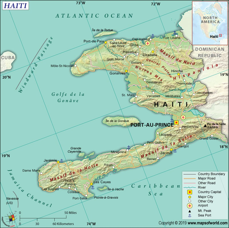
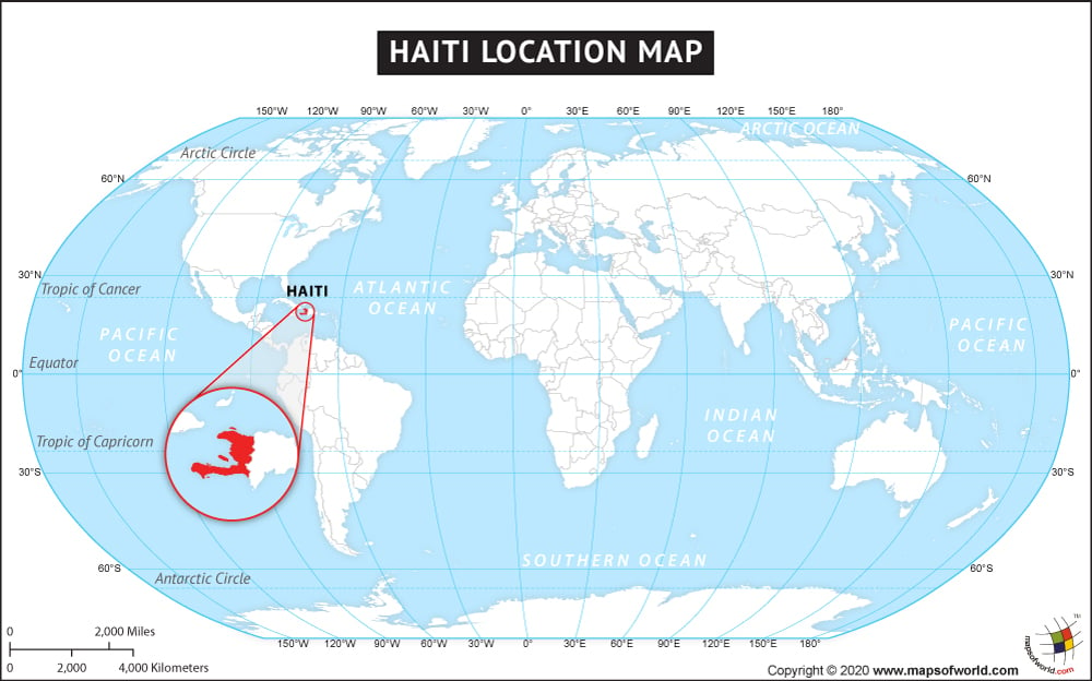
Haiti occupies a 1/3rd of the western Hispaniola Island, located in the Greater Antilles archipelago of the Caribbean Sea. This island nation is situated between the North Atlantic Ocean and the Caribbean Sea. Haiti is situated to the west of the Dominican Republic, which is also located on Hispaniola Island. The Republic of Haiti is located to the east of Jamaica, Cuba and the south of the Turks and Caicos Islands, The Bahamas. The disputed territory Navassa Island (disputed as a US territory under federal administration) is located to the south-west of Haiti.
What is the Geography of Haiti?
Haiti is spread across a total area of 27,750 sq. km (10,710 sq. mi), out of which 27,560 sq. km (10,641 sq. mi) is land area and 190 sq. km (73 sq. mi) is water area. It is the third-largest country in the Caribbean (after Cuba and the Dominican Republic), in terms of area. This country has a 376 km (234 mi) long land boundary, which is entirely shared with the Dominican Republic. It has a 1,771 km (1,100 mi) long coastline, which is the second-largest among the Caribbean islands after Cuba.
Haiti has predominantly rough and mountainous terrain. The mean elevation of the country is 470 m (1,542 ft). While Chaine de la Selle is the highest elevation point at 2,680 m (8,793 ft), the Caribbean Sea is the lowest elevation point at 0 m (0 ft).
The Gonave Gulf separates the two main peninsulas of Haiti: north and south peninsulas. There are three regions in mainland Haiti: the northern region (including the northern peninsula), the central region, and the southern region (including the southern peninsula). Haiti controls several nearby islands. The two most famous islands of this island country are La Gonave and La Tortue.
The three mountain ranges that dominate the landscape are Hood Mountain Range (Massif de la Hotte), Saddle Mountain Range (Massif de la Selle), and Northern Mountain Range (Massif du Nord). Artibonite is the major river that flows through Haiti. There are a few smaller rivers and tributaries such as Guayamouc River and Les Trois Rivières. Major lakes in the country are Lake of Miragoane and salt-water Lake Azuei (also called Etang Saumâtre).
What is the Climate of Haiti?
A tropical climate persists in Haiti, making the country have a hot and humid environment. A dry season continues in Haiti during November-January. However, the fog and drizzle brought by the north wind interrupt the dry season. The weather remains very wet during February-May. The northeast trade winds bring rains during the wet season.
The average precipitation level in this island country is around 1,400-2,000 mm (55-79 in). However, the extent of rainfall is not evenly distributed. The southern peninsula gets more substantial rain than the northern plains as well as mountains. Across the northern peninsula, the extent of precipitation falls as you move from east to west. A moderate amount of rainfall takes place in the eastern central region. The western coast (right from the northern peninsula to the capital Port-au-Prince) is relatively dry.
The lowlands have very high temperatures. While the temperature revolves around 15-25 °C (59-77 °F) during winters, it remains around 25-35 °C (77-95 °F) during summers.
What is the Economy of Haiti?
In 2018, the nominal GDP of Haiti was US$ 9.658 billion, and the annual GDP growth rate was 1.5%. The low-cost labour is its comparative advantage. A large part of the population (2/5th) is dependent upon agriculture, especially subsistence farming.
The major export items of this country are Knit T-shirts, Essential Oils, Knit Women’s Suits, Non-Knit Men’s Suits, Knit Sweaters, etc. The items mainly imported are refined petroleum, rice, palm oil, knit T-shirts, light rubberized knitted fabric, etc. Haiti had a negative balance of trade amounting to US$2.18 billion (US$1.12 billion export value and US$3.3 billion import value).
The level of unemployment was 13.53% in 2018. In the Western Hemisphere, Haiti is the poorest country. Vulnerability to natural disasters, low levels of education, extreme income inequality, rampant corruption, high levels of inflation (around 20%), and a rapid currency depreciation (about 30%) are the main impediments to increasing living standards of people.
The UNDP Millennium Development Goals (MDG) report shows that the wealthiest 1% own as much wealth as 45% of the poorest section of Haiti. Some World Bank reports say that 6 million Haitians live in poverty (living below US$2.41 per day) and 2.5 million people live in extreme poverty (living below US$1.23 per day).
What is the Transportation System of Haiti?
The Republic of Haiti has 4,266 km (2,651 mi) long roadway, out of which 768 km (477 mi) is paved, and 3,498 km (2,174 mi) is unpaved. The main seaports are Cap-Haitien, Port-au-Prince, Jacmel, and Gonaives. There are four merchant marine ships in Haiti.
Fourteen airports are there, out of which four have paved runways, and 10 have unpaved runways. The main airports are Cap-Haïtien International Airport in Cap-Haïtien, Toussaint Louverture International Airport in Port-au-Prince, Jacmel Airport in Jacmel, Antoine-Simon Airport in Les Cayes, Jérémie Airport in Jérémie, and Port-de-Paix Airport in Port-de-Paix.
What International Organizations is Haiti part of?
WTO, IMF, ILO, UN, Petrocaribe, Union Latina, UNESCO, ACP, AOSIS, Caricom, CD, CDB, CELAC, FAO, G-77, IADB, IAEA, IBRD, ICAO, ICRM, IDA, IFAD, IFC, IFRCS, IMO, Interpol, IOC, IOM, IPU, ITSO, ITU, LAES, MIGA, NAM, OAS, OIF, OPANAL, OPCW, PCA, UNCTAD, UNIDO, UNWTO, UPU, WCO, WHO, WIPO, WMO, ICC (NGOs), ITUC (NGOs), WFTU (NGOs)
Related Links:


