What are the Key Facts of Estonia?

|
Official Name |
Republic of Estonia |
|
Continent |
Europe |
|
Capital |
Tallinn |
|
Largest City |
Tallinn |
|
Coordinates |
59.000000, 26.000000 |
|
Area |
17,462 sq. mi (45,228 sq. km) |
|
Land Boundaries |
408 mi (657 km) |
|
Coastline |
2,357 mi (3,794 km) |
|
Currency |
Euro (€) (EUR) |
|
Neighboring Countries |
Latvia, Russia. Maritime Neighbors: Finland, Sweden |
|
Population |
1,326,000 (World Bank, 2019) |
|
Official Languages |
Estonian |
|
Major Religion |
Majority no religion |
|
National Day |
24 February (Independence Day) |
|
National Anthem |
“Mu isamaa, mu onn ja room” |
|
Form of Government |
Unitary parliamentary republic |
|
President |
Kersti Kaljulaid |
|
Prime Minister |
Jüri Ratas |
|
GDP per capita (PPP) |
$ 38,811.1 (World Bank, 2019) |
|
GDP per capita (nominal) |
$ 23,659.9 (World Bank, 2019) |
|
HDI |
0.882 (2019), Rank: 30 |
|
Literacy Rate (%) |
NA |
|
Space Agency |
NA |
|
Military Expenditure Ranking |
78 (SIPRI, 2019) |
|
No. of Olympic Medals |
41 (as of 2018) |
|
Driving Side |
right |
|
Calling Code |
372 |
|
Time Zone |
UTC+2 (EET), Summer (DST)UTC+3 (EEST) |
|
Internet TLD |
.ee |
Where is Estonia?
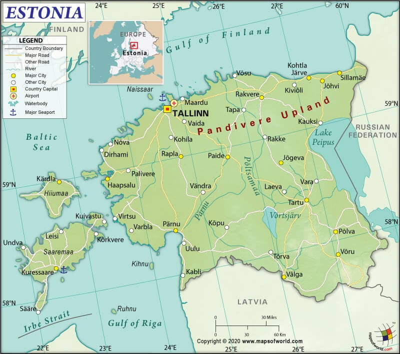
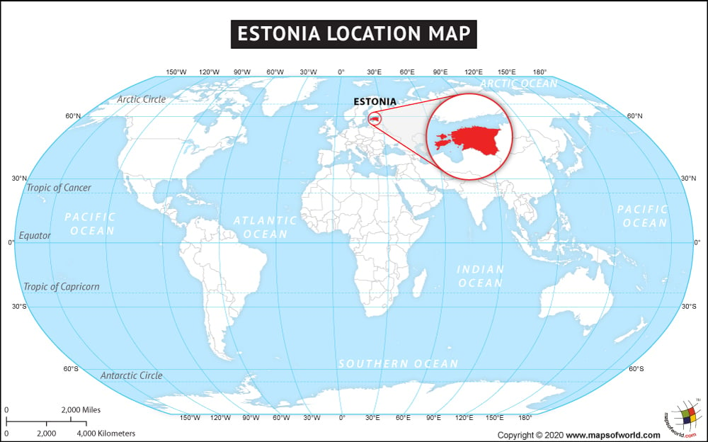
Estonia (whose official name is the Republic of Estonia) is a North European country located between Latvia and Russia, bordering the Baltic Sea and the Gulf of Finland. It is located on the eastern shores of the Baltic Sea immediately across the Gulf of Finland.
What is the Geography of Estonia?
Estonia spreads across a total area of 45,228 sq. km (17,462 sq. mi). Out of the total area, 42,388 sq. km (16,366 sq. mi) is land and 2,840 sq. km (1,096 sq. mi) is water. It is important to note that the country includes 1,520 islands in the Baltic Sea.
The Republic of Estonia’s total land boundary is 657 km (408.2 mi) long. It shares its border with Latvia (333 km or 206.9 mi) to the south and Russia (324 km or 201.3 mi) to the east. Lake Peipus (the largest trans-boundary lake in Europe) borders Estonia to the east. Estonia has a 3,794 km (2357.5 mi) long coastline marked by many bays, straits, and inlets.
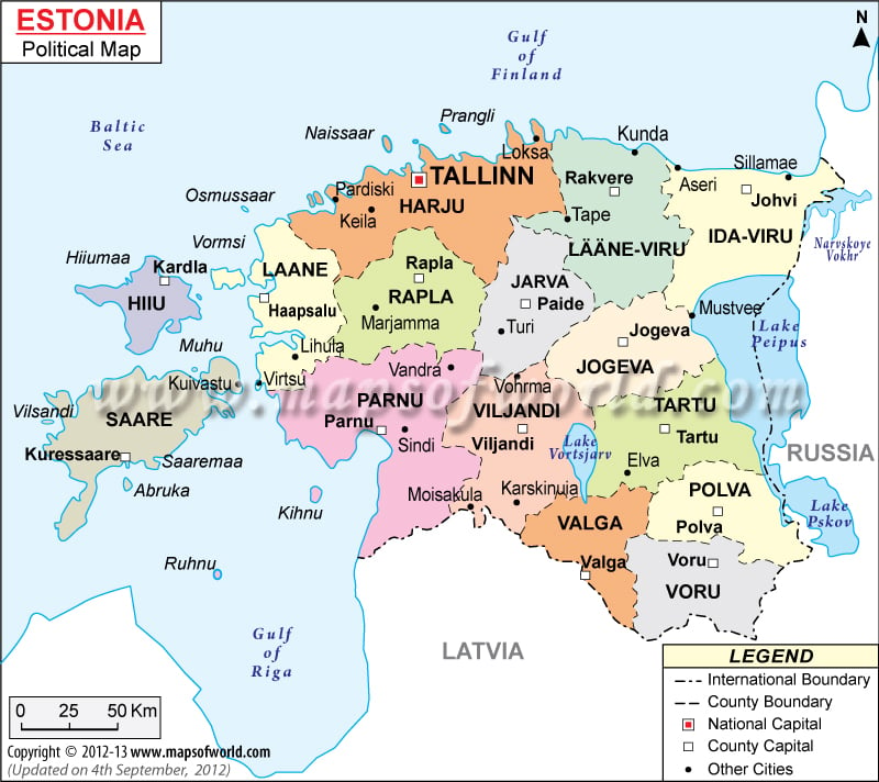
There are as many as 2,355 islands and islets in Estonia, out of which many are located in the lakes. Saaremaa and Hiiumaa are two such islands, which are large enough to constitute separate counties. On Saaremaa, you’ll find a small, recent cluster of meteorite craters, and the largest of them is Kaali.
The mean elevation of Estonia is 61 m (200.1 ft). While the highest point is Suur Munamagi at 318 m (1043.3 ft), the lowest point is the Baltic Sea at 0 m (0 ft). The terrain of Estonia is characterized by marshy lowlands, hilly regions in the south, and flatlands in the north. Almost the entire country is surrounded by water. Closer to the sea level, the land is low and flat.
The highest mountains in the country are Suur Munamägi (Võru County, Võru Parish), Vällamägi (Võru County, Rõuge Parish), Kuutsemägi (Valga County, Otepää Parish), Meegaste (Valga County), etc.
Major rivers of Estonia are Võhandu, Pärnu, Põltsamaa, Pedja, Keila, and many more. There are around 1,400 lakes, and most of them are located in the western parts. The largest lakes are Peipsi (Peipus), Võrtsjärv, Narva Reservoir, Ülemiste, Saadjärv, and others.
What is the Climate of Estonia?
The climate in Estonia is influenced by its location. It is located in the temperate climate zone’s northern part and the transition zone between continental and maritime climate.
The maritime air (influenced by the northern Atlantic Ocean’s heat content) continuously warms the country. That’s why a milder climate is found in this country despite being located in the northern latitude.
A difference in temperature is found between the inland and the coastal areas, mainly because of the Baltic Sea. There are four distinct seasons (Spring, Summer, Autumn, and Winter) found in Estonia, and all of them are almost equal in length.
Spring season (April-May) usually remains mild and dry. The average temperature revolves within 20-30 °C (68-86 °F). While the season of thunder starts in April, the first heatwave arrives in May.
The southern and eastern Estonia get milder and warmer summers. However, the islands remain colder. The average temperature revolves around 20 °C (68 °F), but it reaches up to 30-35 °C (86-95 °F) on some days. While July remains the warmest month, maximum air temperature (35.6 °C or 96.08 °F) is recorded in August.
The season of autumn remains wet and windy. Though the first half of September remains warm, snow starts falling during October-November. Many cyclones and storms can bring heavy rains, causing coastal flooding accompanied by winds over 35 m/s.
During the winter season, the eastern part remains colder than the coastal areas. January and February are the coldest months with the nighttime temperature reaching -35 °C (-31 °F). Snowstorms can be caused due to cyclones. More snow is brought because of the sea effects.
The average temperature in July varies from 16.3 °C (61.3 °F) on the Baltic islands to 18.1 °C (64.6 °F) inland areas. February is the coldest month, and the average temperature varies from -3.5 °C (25.7 °F) on the Baltic islands to -7.6 °C (18.3 °F) in inland areas.
What is the Economy of Estonia?
Estonia has an advanced economy, which is also a member of the eurozone and the European Union (EU). This modern market-based economy is highly dependent on trade and has strong trade ties with Sweden, Finland, Russia, and Germany.
The nominal GDP grew at an annual rate of 4.334% to reach US$31.387 billion in 2019. The economy has a higher per capita income than other countries in Central Europe and the Baltic region.
In 2018, the export and import values were US$17.6 billion and US$21 billion, respectively, resulting in a negative trade balance of -US$3.39 billion. The major exports are Broadcasting Equipment, Refined Petroleum, Coal Tar Oil, Cars, and Prefabricated Buildings. The major imports are Refined Petroleum, Cars, Coal Tar Oil, Broadcasting Equipment, and Packaged Medicaments.
The unemployment rate in Estonia dropped from 16.71% in 2010 to 5.12% in 2019. Though the absolute rate of poverty in Estonia in 2018 was 2.4%, around 21.7% (284,300 Estonian residents) of the population was at the risk of poverty.
What is the Transportation System of Estonia?
Estonia has 18 airports. While 13 have paved runways, 5 have unpaved runways. The major airports of Estonia are Lennart Meri Tallinn Airport (Tallinn), Tartu Airport (Tartu), Kuressaare Airport (Kuressaare), etc. One heliport is also there in the country.
58,412 km (36295.5 mi) long roadway is available, out of which 10,427 km (6479 mi) is paved, and 47,985 km (29816.5 mi) is unpaved. In fact, 115 km (71.5 mi) long expressways are also available. 2,146 km (1333.5 mi) long broad-gauge railway tracks are there in Estonia, out of which 132 km (82 mi) are electrified.
Waterways are around 335 km (208.2 mi) long, out of which 320 km (198.8 mi) remain navigable throughout the year. The country’s major seaports are Tallinn, Sillamae, Kuivastu, Reid, Parnu, Kunda, and Muuga. Estonia has 69 merchant marine vessels.
What International Organizations is Estonia Part of?
WTO, IMF, NATO, UN, WHO, UNESCO, ILO, Australia Group, BA, BIS, CBSS, CD, CE, EAPC, EBRD, ECB, EIB, EMU, EU, FAO, IAEA, IBRD, ICAO, ICCt, ICRM, IDA, IEA, IFAD, IFC, IFRCS, IHO, IMO, Interpol, IOC, IOM, IPU, ISO, ITSO, ITU, MIGA, MINUSMA, NIB, NSG, OECD, OPCW, OSCE, PCA, Schengen Convention, UNCTAD, UNHCR, UNTSO, UPU, WCO, WIPO, WMO, ESA (cooperating state), ICC (national committees), OAS (observer), OIF (observer), ITUC (NGOs)


