What are the Key Facts of Brunei?

|
Official Name |
Brunei Darussalam |
|
Continent |
Asia |
|
Capital |
Bandar Seri Begawan |
|
Largest City |
Bandar Seri Begawan |
|
Coordinates |
4.500000, 114.666667 |
|
Area |
2,226 sq. mi (5,765 sq. km) |
|
Land Boundaries |
165 mi (266 km) |
|
Coastline |
100 mi (161 k.) |
|
Currency |
Brunei dollar (BND) |
|
Neighboring Countries |
Malaysia |
|
Population |
433,000 (World Bank, 2019) |
|
Official Languages |
Malay |
|
Major Religion |
Islam |
|
National Day |
23 February (National Day) |
|
National Anthem |
“Allah Peliharakan Sultan” |
|
Form of Government |
Absolute monarchy or sultanate |
|
Sultan |
Hassanal Bolkiah |
|
Prime Minister |
Hassanal Bolkiah |
|
GDP per capita (PPP) |
$ 64,673.3 (World Bank, 2019) |
|
GDP per capita (nominal) |
$ 31,086.8 (World Bank, 2019) |
|
HDI |
0.845 (2019), Rank: 43 |
|
Literacy Rate (%) |
97.21 (UNESCO, 2018) |
|
Space Agency |
NA |
|
Military Expenditure Ranking |
92 (SIPRI, 2019) |
|
No. of Olympic Medals |
0 (as of 2018) |
|
Driving Side |
left |
|
Calling Code |
673 |
|
Time Zone |
UTC+8 (Brunei Darussalam Time) |
|
Internet TLD |
.bn |
Where is Brunei?
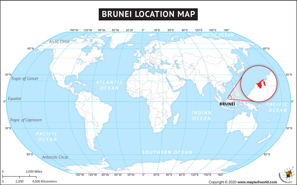
Brunei (whose official name is the Nation of Brunei, the Abode of Peace, called Negara Brunei Darussalam in Malay) is a Southeast Asian country located along the northern coast of the island of Borneo. It borders the South China Sea and Malaysia.
What is the Geography of Brunei?
Brunei spreads across a total area of 2,226 sq. mi (5,765 sq. km). Out of the total area, 2,033 sq. mi (5,265 sq. km) is land, and 193 sq. mi (500 sq. km) is water.
The Nation of Brunei’s total land boundary is 165.3 mi (266 km) long. It shares its complete border (165.3 mi or 266 km) with Malaysia. Brunei has a coastline of 100 mi (161 km).
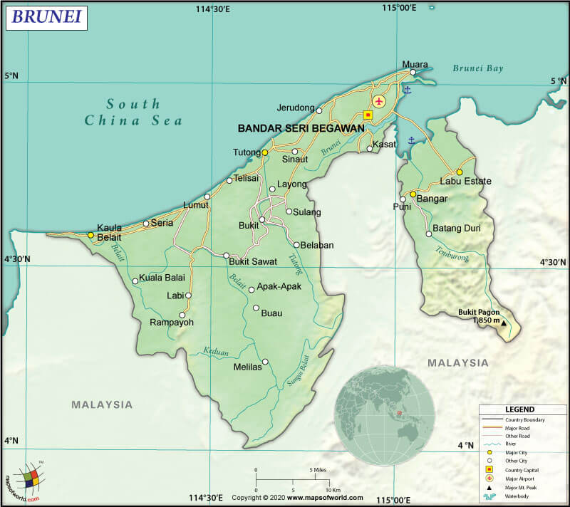
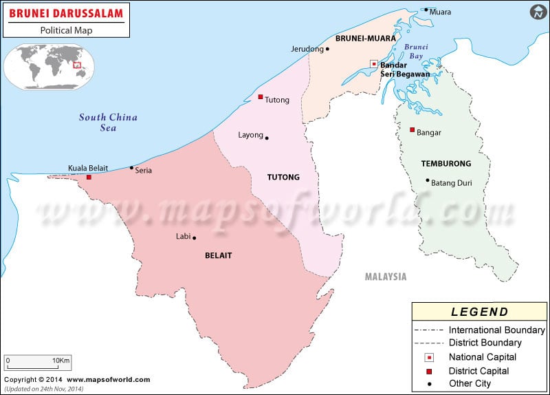
Besides the South China Sea, Malaysia’s Sarawak (the insular Malaysian state) surrounds Brunei. The Sarawak district of Limbang separates Brunei into two parts. The Temburong District of eastern Brunei is detached from the main territory.
Brunei is the only sovereign state in the world that is on the island of Borneo. This island nation’s remainder territory divides between Indonesia and Malaysia.
Brunei is located majorly in the lowland rain forests of Borneo. The landscape can be characterized as fertile, hilly lowland. The primary and secondary forests cover around 48% and 28% of the country’s total area, respectively. In the eastern part of the country, mountainous areas are present. Peat swamp covers a significant part of Brunei’s western part.
The mean elevation of Brunei is 1568.2 ft (478 m). While the highest point is Bukit Pagon at 6069.6 ft (1850 m), the lowest point is the South China Sea at 0 ft (0 m). The other major mountain peaks, beside Bukit Pagon, in Brunei, are Bukit Retak, Bukit Lesong, Bukit Tudal, Bukit tanggoi, etc.
There are four major rivers in the country: Belait River, Tutong River, Temburong River, and Brunei River. Tasek Merimbun (also called Merimbun Lake in Malay) is the country’s largest natural lake.
What is the Climate of Brunei?
The climatic condition of Negara Brunei Darussalam can be classified as wet tropical where the monthly average temperature revolves within 80.06 °F (26.7 °C) and 81.86 °F (27.7 °C). The average rainfall per month remains around 14.8 inches (375 mm). As per Köppen-Geiger climate classification, the climate in Brunei is classified as Af.
Two monsoons influence this country. The country gets its first monsoon starts in April and continues till August. It is called the weaker south-west monsoon. The second monsoon is known as the more vigorous north-east monsoon, starting in October and continuing till January. The higher altitudes of Brunei get heavy rainfall.
The climate of the municipality of Bandar Seri Begawan is tropical equatorial. Two seasons can be found here. While the wet season remains wet and warm with a temperature ranging within 20-28 °C (68.0-82.4 °F), the dry season remains extremely hot with the temperature revolving within 24-36 °C (75.2-96.8 °F).
As per regions, Negara Brunei Darussalam can be divided into four parts:
- In Brunei-Muara District and Bandar Seri Begawan, the temperature revolves within 68-97 °F (20-36 °C). While the coastal and lower altitude in the north gets a humid tropical climate, the central Brunei-Muara District experiences a humid subtropical climate.
- A tropical climate prevails in the Tutong District of the country. While the northern part remains hot, the southern region of the district remains warm. The average temperature in Brunei’s Tutong revolves within 71.6-89.6 °F (22-32 °C)
- Belait District also has a similar climatic condition as the Tutong district. The Northern part of Belait remains hot, and the southern part remains slightly warm. The average temperature revolves within 77-98.6 °F (25-37 °C).
- A humid subtropical climatic condition is found in the Temburong District. The southern part of the district has a higher altitude than that of the north, and the average temperature revolves around 64-84 °F (18-29 °C).
What is the Economy of Brunei?
Brunei is an energy-rich, small and wealthy sultanate, whose economy is characterized by a mix of entrepreneurship (domestic as well as foreign), village traditions, welfare measures, and government regulation.
More than half (65%) of the GDP comes from the export of crude oil and natural gas. Petroleum is mainly exported to Japan, and its trading accounts for around 95% of the total exports of the economy. The economy of Brunei boasts of having a well-educated, mostly English-speaking population and an excellent infrastructure.
Brunei’s economy has a high per capita GDP, supplemented by overseas investment. The government provides all medical services and food/housing subsidies.
The nominal GDP of Brunei Darussalam increased at an annual rate of 3.869% to US$13.469 billion in 2019. Major export items are Petroleum Gas, Crude Petroleum, Acyclic Alcohols, Aircraft Parts, and Spark-Ignition Engines. Major imports of Brunei are Planes, Helicopters, and Spacecraft, Refined Petroleum, Iron Structures, Cars, and Other Heating Machinery.
The unemployment rate in this Southeast Asian country has increased significantly from 5.16% in 2008 to 9.12% in 2019. Around 46% of the population in 2012 reportedly earned less than $1,000, and around half of the population has to depend on welfare for survival.
What is the Transportation System of Brunei?
Brunei has only one airport with a paved runway (over 9996.7 ft or 3,047 m) and three heliports. The Brunei International Airport is located in the Brunei-Muara district and serves the Bandar Seri Begawan district.
There is a 1849.2 mi (2,976 km) long roadway in the country, out of which 1590 mi (2,559 km) are paved, and 259.1 mi (417 km) are unpaved. No railway is present in Brunei.
129.9 mi (209 km) of waterways are available in Brunei, where the major transport links are Tutong Rivers, Brunei, and Belait. Craft drawing less than 1.2 m can navigate through the water-bodies. Muara is the principal seaport, Lumut is the leading LNG export terminal, and Seria and Lumut are the major oil terminals.
The country has 104 merchant marine vessels, out of which 18 are general cargo, 2 are oil tankers, and 84 are other vessels.
What International Organizations is Brunei part of?
WTO, IMF, UN, WHO, UNESCO, ILO, ADB, APEC, ARF, ASEAN, C, CP, EAS, FAO, G-77, IAEA, IBRD, ICAO, ICRM, IDA, IFRCS, IMO, IMSO, Interpol, IOC, ITSO, ITU, NAM, OIC, OPCW, UNCTAD, UNIFIL, UNWTO, UPU, WCO, WIPO, WMO, ICC (NGOs), ISO (correspondent)
Related Links:


