What are the Key Facts of Albania?

|
Official Name |
Republic of Albania |
|
Continent |
Europe |
|
Capital |
Tirana |
|
Largest City |
Tirana |
|
Coordinates |
41.000000, 20.000000 |
|
Area |
11,100 sq. mi ( 28,748 sq. km) |
|
Land Boundaries |
429 mi ( 691 km) |
|
Coastline |
225 mi ( 362 km) |
|
Currency |
Lek (ALL) |
|
Neighboring Countries |
Montenegro, Kosovo, North Macedonia, Greece |
|
Population |
2,876,591 (2017 est.) |
|
Official Languages |
Albanian |
|
Major Religion |
Islam, Christianity |
|
National Day |
28 November (Independence Day) |
|
National Anthem |
“Hymni i Flamurit” |
|
Form of Government |
Unitary parliamentary constitutional republic |
|
President |
Ilir Meta |
|
Prime Minister |
Edi Rama |
|
GDP per capita (PPP) |
$ 13,325.6 (World Bank, 2018) |
|
GDP per capita (nominal) |
$ 5,253.6 (World Bank, 2018) |
|
HDI |
0.785 (2017), Rank: 68 |
|
Literacy Rate (%) |
98.14 (UNESCO, 2018) |
|
Space Agency |
NA |
|
Military Expenditure Ranking |
116 (SIPRI, 2017) |
|
No. of Olympic Medals |
0 (as of 2018) |
|
Driving Side |
right |
|
Calling Code |
+355 |
|
Time Zone |
UTC+1(CET), Summer (DST) UTC+2 (CEST) |
|
Internet TLD |
.al |
Where is Albania?
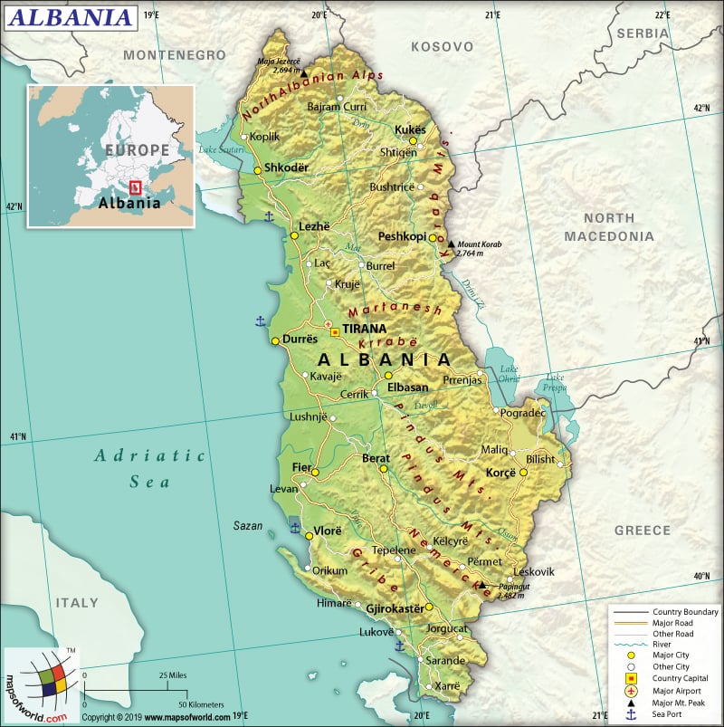
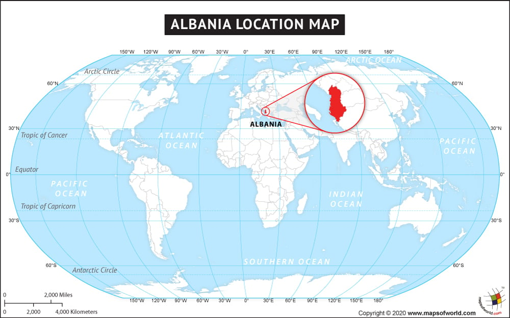
Albania is a Southeast European country that borders the Adriatic Sea and the Ionian Sea within the Mediterranean Sea. This country is bordered by Italy to the west, Montenegro to the west and the northwest, Greece to the south, North Macedonia to the east, and Kosovo to the northeast.
What is the Geography of Albania?
Albania is spread across a total area of 28,748 sq. Km (11,100 sq. mi), out of which 27,398 sq. Km (10,578 sq. mi) is land area and 1,350 sq. Km (521 sq. mi) is water. The country has a 691 km (429.37 mi) long land boundary, which is shared with four countries: Greece (212 km or 132 mi), Montenegro (186 km or 116 mi), Macedonia (181 km or 112 mi), and Kosovo (112 km or 70 mi). Albania has a 362-km (225 mi) long coastline.
The terrain of Albania mainly consists of mountains and hills. Small plains are also there, but they are primarily found in the coastal areas. The mean elevation of the country is 708 m (2,323 ft). While Maja e Korabit (Golem Korab) at 2,764 m (9,068 ft) is the highest elevation point of the country, the Adriatic Sea at 0 m (0 ft) is the lowest elevation point. The highest elevation point is located in the Korab Mountains that stretch along and through the Macedonian border.
In front of the Adriatic Sea, a broad and swampy coastal plain is located. The hills and mountains (making up around 70 percent of the total land area) start from there. The Albanian Alps, as well as the Korab and Pindus Mountains, are the major ranges located in the country. Major rivers such as the Drin and Vlore flow inland from the mountains towards the Adriatic Sea.
There are 3 major lakes in the country, and they are Ohrid, Shkodra, and Prespa. In the Balkans, the deepest lake is the Ohrid, which has a maximum depth of 284 m (935 ft).
A Mediterranean climate persists in Albania. While the summers are hot and dry, the winters are mild and wet. The temperature varies as per the altitude (especially between the highlands and lowland coasts). In general, the climate remains pleasant round the year.
In the lowlands, the average winter temperature hovers around 7 ˚C (44.6 ˚F) and the average summer temperature hovers about 24 ˚C (75 ˚F). The average rainfall amount is between 1,000 mm (39.4 in) to 1,500 mm (59 inches).
In the highlands, the average winter temperature during January revolves around -1 ˚C (30 ˚F). However, during peak summer, the temperature hovers in the mid 20 ˚C (68 ˚F) range.
What is the Economy of Albania?
The economy of Albania is currently a modern open-market economy that has grown and improved since 2014. The nominal GDP grew at a rate of 4% in 2018 to reach US$ 15.059 billion.
The main exported items are leather footwear, footwear parts, ferroalloys, chromium ore, crude petroleum, etc. The major import items are refined petroleum, cars, footwear parts, tanned equine and bovine hides, packaged medicaments, etc. In 2017, the values of exports and imports were US$2.39 billion and US$4.21 billion, respectively, thereby resulting in a negative balance of trade of US$1.82 billion.
The rate of unemployment had deteriorated marginally from 13.75% in 2017 to 13.90% in 2018. Currently, Albania is one of the poorest European countries. About 1/4th of the total population (around 800,000 persons) still lives in extreme poverty (living at the US $2 per day). Poverty is more severe in rural areas than urban ones. As 57% of the total population lives in the rural areas of Albania, more than half of the country is still struggling to provide adequate food to their families.
What is the Transportation System of Albania?
The Albanian transport system mainly consists of roadways, airways, and waterways. The transport system in the country is supervised by the Ministry of Infrastructure. The country has focused on improving its overall transport infrastructure (air travel, road, and urban transport) in recent years. The substantial investment in construction and infrastructure in the last decade has helped the economy to sustain and grow.
Albania has 3,945 km (2,451 mi) long roadway and 677 km (421 mi) of railways. Some of the major motorways are Durrës–Tirana–Lezhë–Kukës, Tirana–Elbasan, and Fier–Vlorë. The most popular expressways in Albania are Durrës–Lezhë–Shkodër–Tirana, Durrës–Tirana, Elbasan- Korçë–Tirana, Elbasan, Fier–Vlorë, Elbasan–Tirana, and Durrës-Fier-Gjirokastër-Tirana.
All the railway tracks are standard-gauge. While 447 km (278 mi) are major railway lines, 230 km (143 mi) are secondary lines. Over 41 km (25.5 mi) of waterways on the Bojana River are also available. The major seaports are Durres, Vlore, Shengjin, and Sarande. Around 60 merchant marine ships are operational in the country. The country has four airports, and all of them are paved, and one heliport is also there. Tirana International Airport is the most important airport in the country.
What International Organizations is Albania part of?
WTO, IMF, UN, UNESCO, WHO, NATO, BSEC, CD, CE, CEI, EAPC, EBRD, FAO, IAEA, IBRD, ICAO, ICCt, ICRM, IDA, IDB, IFAD, IFC, IFRCS, ILO, IMO, Interpol, IOC, IOM, IPU, ITU, MIGA, OIC, OIF, OPCW, OSCE, PCA, SELEC, UNCTAD, UNIDO, UNWTO, UPU, WCO, WIPO, WMO, EITI (compliant country), ICC (national committees), ISO (correspondent), OAS (observer), ITUC (NGOs), WFTU (NGOs)
Related Maps:


