What is the International Date Line?

International Date Line Map
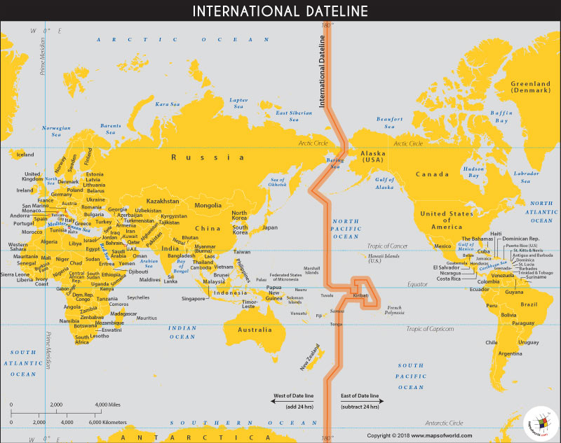
The International Date Line Map shows an imaginary line running from the North pole to the South pole, corresponding its length to the 180th meridian on the surface of the earth. It demarcates two consecutive calendar days, resulting in the Eastern side of the line ahead by one day and the Western side behind by a day. It is the consequence of the worldwide use of timekeeping systems so that the local noon in respective nations corresponds approximately to the time at which the sun crosses the local meridian of longitude.
Running down in the middle of the Pacific Ocean, the International Date Line is halfway around the Greenwich Meridian. It roughly follows the 180-degree meridian with some deviating east and west at certain places. This is done in order to accommodate the political and economic affiliations of the affected areas. The IDL, is not a matter of international law and lacks a regulatory body but is embraced globally. This is crucial for global interconnectivity, communication, time management, and carrying out worldwide economic activities.
The prime reason for choosing the 180-degree meridian as the IDL, is due to its crossing through open oceans in the central pacific, with little deviations to keep the nations on the same day and date. Thus, the International Meridian Conference, held in Washington, D.C., in 1884, decided on the International Date Line map to address the problems of varying times and dates. The location of IDL was determined on both land and adjacent territorial waters as well as open seas. All nations have the freedom to decide their Standard Time Zones, applicable only to their land and territorial waters. This is also called the de facto line since it is based on national laws and does not fall under the jurisdiction of international laws. Whereas the de jure line is the Nautical Date Line, which is constructed by an international agreement. It differs from the International Date Line. It recommends all ships, both military and civilian to adopt hourly Standard Time Zones on the high seas. It follows the 180-degree meridian unless interrupted by the territorial waters, in which case, they are expected to adapt to the standard time of the country.
From North to South, the first deviation from the 180-degree longitude is to pass to the east of Wrangel Island and Chukchi Peninsula, the easternmost part of Russian Siberia. Following this, it passes through the Bering Strait, and then bends west of the 180-degree longitude, passing west of St. Lawrence Island and St. Matthew Island. The IDL crosses between the U.S. Aleutian Islands and the Russian Commander Islands. To keep the whole of Russia to the West and the U.S. to the east, it bends southeast again and returns to 180-degree longitude. It passes the Equator while following the 180th meridian, implying the two US-owned uninhabited atolls of Howland Island and Baker Island with the latest time on earth. The IDL circumscribes Kiribati by curving to the east, with the easternmost islands of the country having the most advanced time. South of Kiribati, the line returns westwards but remains east of 180 degrees, passing between Samoa and American Samoa.
Regions like Samoa, Tokelau, Wallis and Futuna, Fiji, Tonga, Tuvalu, and New Zealand’s Kermadec Islands and the Chatham Islands, fall West of the IDL and are on the same dates. Whereas regions like American Samoa, the Cook Islands, Niue, and French Polynesia lie on the east of the IDL and lag by a day. The IDL, returning to the 180th meridian runs in sync until reaching Antarctica. Conventionally, the IDL is not drawn through Antarctica on the maps.
To escape inconvenience the IDL has been changed by nations on certain occasions. The most recent alteration was made by Samoa in 2011, by shifting the dateline to the west and eliminating December 30th, 2011, from the calendar. This was carried forward in order to facilitate trade with the nations of Australia and New Zealand. The state of Tokelau also followed the same route for similar economic exchanges with Samoa. Kiribati, an island nation of 32 atolls that straddles the Equator changed the line to the east, in order to keep the entire country on the same date, 1995. Other ancient deviations include the Philippines, formerly on the east side despite being far on the western edge of the Pacific Ocean. From 1521 to 1844, it was one day behind its Asian neighbors. The transition from the eastern to the western end was done in December 1844. The transfer of ownership of Alaska from Russia to America led to the shift from the Asian and Julian date to an American and Gregorian date. This was done in 1867 and was also marked as ‘Alaska Day.’
Hence, by moving from East to West, a traveler would gain time. Contradictory to this, an individual traveling from West to East would lose a day. But this varies depending on the time zone followed by the respective nations, implying the difference is not always 24 hours.
Related maps:


