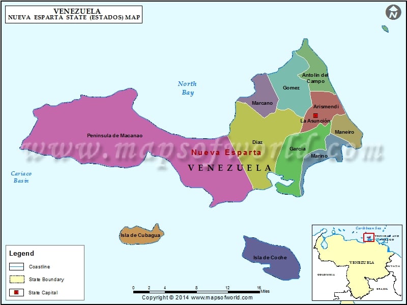
One of the 23 states of Venezuela, Nueva Esparta is a very important region of the country. The state consists of three islands, Daisy, Coche and Cubagua. The capital city of the state is Asuncio’n.
The state of Nueva Esparta is the smallest one in the country in respect of land area, and also the only parochial state of Venezuela. The name of the state is derived from the great courage shown by the populace of this state throughout the Venezuelan War of Independence.
Location of Nueva Esparta
The Nueva Esparta state is located to the north of the state of Sucre in Venezuela. It is situated facing the Peninsula of Araya. The waters of the Caribbean Sea surround the state. The location of the Nueva Esparta makes it a unique and conspicuous region in Venezuela.
History of Nueva Esparta
Nueva Esparta was explored on the 15th of August 1498. Cristobal Columbus discovered this state during his third voyage, in which he had also discovered Venezuela as a country. Three islands were found by Columbus, two of them small, low and barren, and another bigger one, separated by a channel. The latter island had plenty of vegetation and was inhabited by natives who called themselves Paraguachoa. This bigger island was christened as Asuncio’n by Columbus, as it was found on a religious date related to a Virgin with the same name. The following year, in 1499, this island was named again as ‘Daisy’, due to the profusion of daisies that grew in the surrounding area of the coasts.
Economy of Nueva Esparta
Economy of Nueva Esparta is based mainly on tourism, and also on industry and commerce. Construction and transport are also two major industrial activities of this region. Agricultural and mining operations are relatively less developed in this area. Tourist activity in Nueva Esparta is significant as it makes a huge fiscal contribution to the Gross Territorial Product of Venezuela. Tourism and Free Port produce a sizeable currency access to the country.
Most of the population of Nueva Esparta live in the bigger island called Daisy, which also contains the capital of the state. The state has an average temperate climate.
Municipalities of Nueva Esparta State (Estado) |
| Municipality | Capital | Population | Area(km.²) |
|---|---|---|---|
| Antolín del Campo | Plaza Paraguachi | 20,325 | 66 |
| Arismendi | La Asunción | 23,097 | 55 |
| Díaz | San Juan Bautista | 47,257 | 141 |
| García | El Valle del Espíritu Santo | 45,606 | 89 |
| Gómez | Santa Ana | 30,237 | 91 |
| Maneiro | Pampatar | 35,400 | 38 |
| Marcano | Juan Griego | 28,256 | 43 |
| Mariño | Porlamar | 84,534 | 39 |
| Península de Macanao | Boca del Río | 20,935 | 320 |
| Tubores | Punta de Piedras | 29,962 | 207 |
| Villalba | San Pedro de Coche | 8,242 | 61 |

