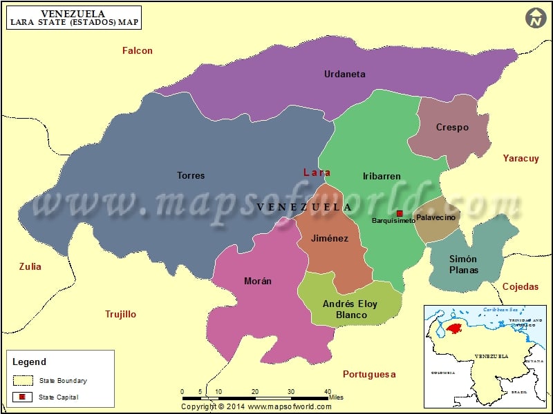
The state of Lara draws its name from the great personality General Jacinto Lara, who played an important role in the independence of the city of Tocuya. Lara is situated on the western side of the South American country of Venezuela. The state of Falcon borders the northern side of Lara, whereas the states of Portuguesa and Trujillo lie to the south of this state. The city of Barquisimeto serves to be the capital of this state. The well-known Spanish conquerer, Juan de Villegas had established this city in the year 1552.
Geography of Lara
Lara measures approximately 7,645 square miles or 19,800 square kilometers in area and forms a portion of the Segovia Highlands. A major portion of this state falls in the Andes Mountain Range. The river known as Tocuya runs from the southwestern part to the northeastern part of Lara. This river finally unites with the Caribbean Sea.
Economy of Lara
Retailers, cattle dealers and agriculturists contribute significantly to the economy of the state of Lara. The capital city of Barquisimeto serves to be the chief commercial center of this state. The main agricultural products of this state include maize, citric cane sugar, coffee, tomatoes, popes, onions, grapes, cocuiza, pimentones and many more. Trees like samanes, ceibas, cedars and others are also found in this state.
Tourism in Lara
The various temples, theaters, museums, musical and cultural activities of the capital city attract a lot of tourists. Another city Quibor is also famous for its museums and crafts.
Municipalities of Lara State (Estado) |
| Municipality | Capital | Population | Area(km.²) |
|---|---|---|---|
| Andrés Eloy Blanco | Sanare | 42,067 | 872 |
| Crespo | Duaca | 42,432 | 776 |
| Iribarren | Barquisimeto | 895,989 | 2,763 |
| Jiménez | Quibor | 81,484 | 879 |
| Morán | El Tocuyo | 112,484 | 2,305 |
| Palavecino | Cabudare | 134,402 | 270 |
| Simón Planas | Sarare | 28,787 | 873 |
| Torres | Carora | 164,045 | 7,437 |
| Urdaneta | Siquisique | 54,725 | 3,625 |

