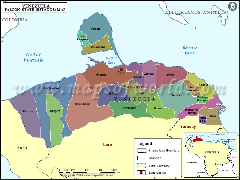
Falcon is a Venezuelan state, which is situated in the north western part of the country. The Falcon state was named after Juan Crisostomo Falcon. Choir city is the capital of Falcon. According to the 2001 census report the total population of Falcon State of Venezuela was 7,63,000 people.
The main cities of the state are Dabajuro, Mirimire, Santa Ana, End Teasel, Chichiriviche, Fixed Point and Churuguara. Some parts of the state are situated in the Paraguana peninsula and some parts in Coriano System, which largely comprise mountainous regions.
The main economic activity of people residing in Falcon is farming. The major agricultural products are maize, sugar, banana, melons, onions, palms popes, coconuts, caraotas, sorghum and melons. Coffee is cultivated in the mountains.
Bird and cattle rearing activities are common in the country specially in Choir and eastern part of the state. Besides, some of the biggest South American oil refineries are located in Paraguana Peninsula, Amuay and Cardon. Fishing is also an important means of earning livelihood in Falcon. The areas where fishing has developed extensively are Zazarida, Paraguana, Puerto Cumarebo and Chichiriviche.
Falcon is an attractive tourist site. The beautiful beaches and landscapes attract many travelers, making Falcon one of the most visited sites of the country. Some of the wonderful tourist sites of Falcon are Choir’s Xerofito Garden, Paraguna’s Church in Moruy and Morrocoy Park.
Morrocoy Park is located between Chichiriviche and Tucacas. This park offers the best eco-tourism opprotunities for the tourists. It consists of a number of small desolate islands, and the enchanting beaches provide a spectacular experience.
The best way to enjoy the islands of Morrocoy is to travel by boat. Nearby towns like Chichiriviche and Tucacas provide better lodging arrangements for travelers.
Municipalities of Falcon State (Estado) |
| Municipality | Capital | Population | Area(km.²) |
|---|---|---|---|
| Acosta | San Juan de los Cayos | 17,078 | 757 |
| Bolívar | San Luís | 8,290 | 295 |
| Buchivacoa | Capatárida | 20,269 | 2,657 |
| Cacique Manaure | Yaracal | 7,608 | 190 |
| Carirubana | Punto Fijo | 203,583 | 684 |
| Colina | La Vela de Coro | 32,545 | 582 |
| Dabajuro | Dabajuro | 17,534 | 1,144 |
| Democracia | Pedregal | 9,107 | 2,602 |
| Falcón | Pueblo Nuevo | 40,879 | 1,577 |
| Federación | Churuguara | 25,889 | 1,084 |
| Jacura | Jacura | 11,500 | 1,842 |
| Los Taques | Santa Cruz de Los Taques | 28,528 | 231 |
| Mauroa | Mene de Mauroa | 21,468 | 1,904 |
| Miranda | Santa Ana de Coro | 173,860 | 1,805 |
| Monseñor Iturriza | Chichiriviche | 17,774 | 907 |
| Palmasola | Palmasola | 6,340 | 194 |
| Petit | Cabure | 12,078 | 1,025 |
| Píritu | Píritu | 9,929 | 1,168 |
| San Francisco | Mirimire | 10,000 | 346 |
| Silva | Tucacas | 28,820 | 537 |
| Sucre | La Cruz de Taratara | 5,155 | 840 |
| Tocopero | Tocopero | 4,475 | 83 |
| Unión | Santa Cruz de Bucaral | 14,479 | 975 |
| Urumaco | Urumaco | 6,861 | 752 |
| Zamora | Puerto Cumarebo | 29,139 | 619 |

