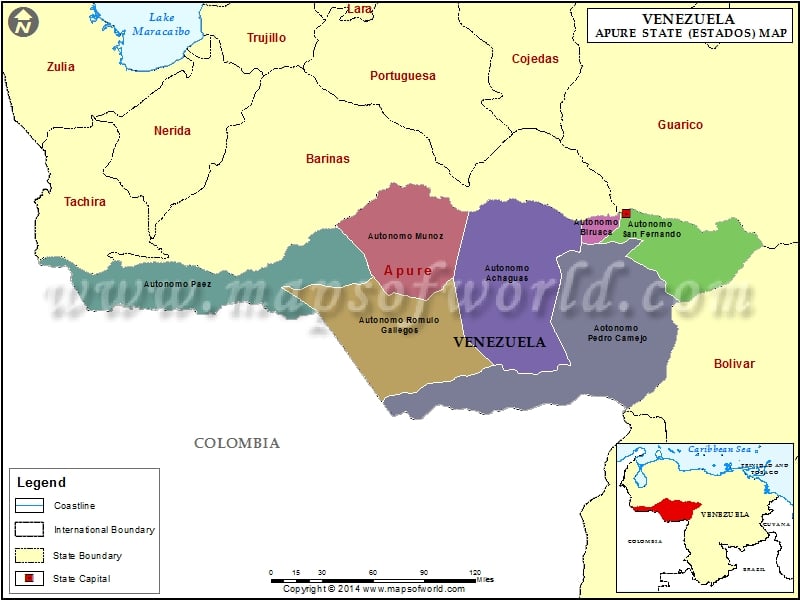
Apure is one of the states of Venezuela situated in the southwestern part of Venezuela. San Fernando de Apure is the capital of the state of Apure. Apure covers an area of 80,000 square kilometers and is bounded by Barinas and Guarico in the North, Colombia in the south, Orinoco River and the state of Bolivar in the east. The state became independent in the 19th century. The cowboys or the llaneros as they are famously known in the state contributed a lot in the freedom struggle.
Apure is one of the most beautiful states in Venezuela. The vast stretches of greenery, the tropical savanna all help in promoting the state as one of the best tourist spots in the world. The place is quiet and peaceful. The serenity of this Venezuelan place also appeals to the tourists. The diurnal range of temperature of Apure is between 24º centigrade and 28º centigrade.
Apure is inhabited by a large population which consists of various racial groups including Achaguas, Elorza, Bruzual, San Fernando de Apure and the Guadualitos. The natural vegetation of the place is very rich as the soil is fertile and there are lots of rivers flowing through the region. The rivers also contribute in providing a profession for the people of Apure, that of seafaring.
A major part of the population depends on agriculture to sustain their lives. The farmers produce cotton, maize, beans, cassava and cambur. They also breed cattle for milk and meat. Fishing is another means of sustenance for the people of the state. However, the industry is not much developed and is mostly limited in areas like San Fernando, the capital, and Guasdualito.
Apure is home to three national parks. The names are:
- Old River
- Cinaruco
- The Tama
Apure possesses a rich cultural heritage. The residents are proud of their heritage. Their food habits comprise of roasted meat, the joropo, their folk music make up their culture.
Municipalities of Apure State (Estado) |
| Municipality | Capital | Population | Area(km.²) |
|---|---|---|---|
| Achaguas | Achaguas | 49,781 | 15,754 |
| Biruaca | Biruaca | 43,119 | 1,281 |
| Muñoz | Bruzual | 24,397 | 7,925 |
| Páez | Guasdualito | 88,598 | 12,820 |
| Pedro Camejo | San Juan de Payara | 23,334 | 20,519 |
| Rómulo Gallegos | Elorza | 16,589 | 12,219 |
| San Fernando | San Fernando de Apure | 131,938 | 5,982 |

