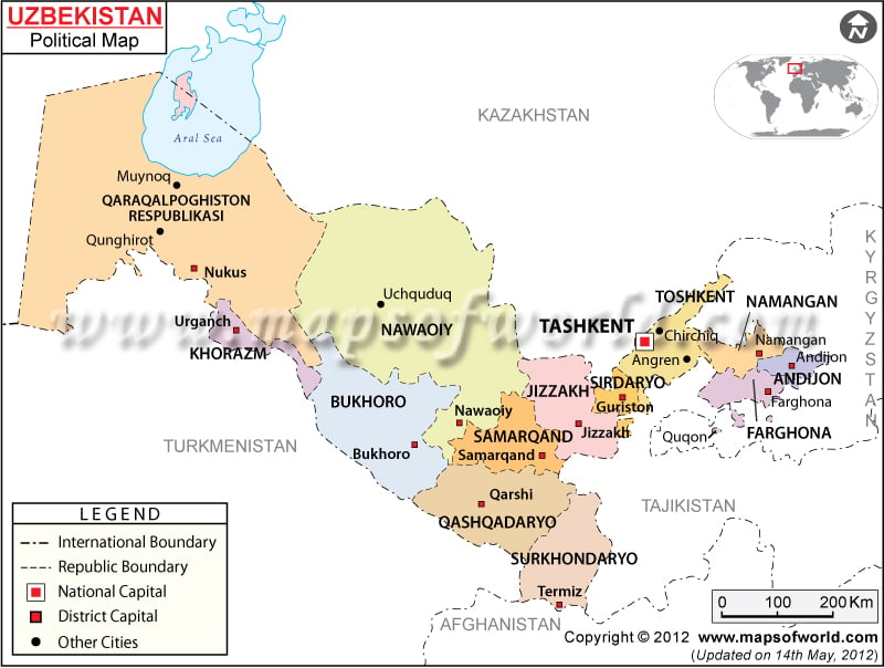
Uzbekistan political map is a visual representation of the country’s district capitals, major cities and the national capital.
The republican boundaries are differentiated with broken lines. The black dots on the online Uzbekistan map represent the major cities and the white squares point the district capitals. The printable map of Uzbekistan is very helpful for students and discerning travelers.
Uzbekistan political map may be used for presentations, brochures and so on. The country is situated on the central part of Asia. The geographical coordinates of the country are 41° North latitude and 64° East longitude. The country borders with Afghanistan, Tajikistan, Turkmenistan, Kyrgyzstan and Kazakhstan. The national capital of the country is Tashkent.
Location of Uzbekistan
The online Uzbekistan political map points the country in Central Asia. The bordering countries are Afghanistan, Tajikistan, Turkmenistan, Kyrgyzstan and Kazakhstan. The geographical coordinates of the country are 41° North latitude and 64° East longitude. The total area of the country is 447,400 square kilometer. From the total area the land area covered is 425,400 square kilometers and the rest 22,000 square kilometers is covered by water bodies. However the country is landlocked but a portion of it borders with Aral Sea. The highest point is Adelunga Toghi situated at 4,301 meters above sea level. The lowest point is Sariqarnish Kuli, which is 12 meters below the sea level.
Capital of Uzbekistan
The red dot on the detailed Map of Uzbekistan points the capital city of Uzbekistan. The geographical coordinates of the city are 41°19′ North latitude and 69° 15′ east longitude. The city is situated at an altitude of 459 meters. The nearby towns and cities are Koshkurgan, Yalanghoch, Quyliq, Qoraqamish, Aktepa and Yunusobod. Yuzhny, Chirchik, Chimkent Sayram and Tashkent Vostochny are the airports of the city, which are served by many international airlines.
| Region | Population | Area(km.²) | Area(mi.²) | Capital | Russian |
|---|---|---|---|---|---|
| Andijon | 2,116,000 | 4,200 | 1,600 | Andijon | Andizhanskaya Oblast’ |
| Buxoro | 1,379,000 | 39,400 | 15,200 | Buxoro | Bukharskaya Oblast’ |
| Farg`ona | 2,584,000 | 6,800 | 2,600 | Farg`ona | Ferganskaya Oblast’ |
| Jizzax | 924,000 | 20,500 | 7,900 | Jizzax | Dzhizakskaya Oblast’ |
| Karakalpakstan | 1,456,000 | 165,600 | 63,900 | Nukus | Karakalpakskaya A.S.S.R. |
| Kashkadarya | 2,067,000 | 28,400 | 11,000 | Qarshi | Kashkadar’inskaya Oblast’ |
| Namangan | 1,858,000 | 7,900 | 3,100 | Namangan | Namanganskaya Oblast’ |
| Navoi | 769,000 | 110,800 | 42,800 | Navoi | Navoiyskaya Oblast’ |
| Samarkand | 2,585,000 | 16,400 | 6,300 | Samarkand | Samarkandskaya Oblast’ |
| Sirdaryo | 650,000 | 5,100 | 2,000 | Guliston | Syrdar’inskaya Oblast’ |
| Surxondaryo | 1,660,000 | 20,800 | 8,000 | Termiz | Surkhandar’inskaya Oblast’ |
| Tashkent | 2,311,000 | 15,000 | 5,800 | Tashkent | Tashkentskaya Oblast’ |
| Tashkent City | 2,138,000 | 300 | 100 | Tashkent | |
| Xorazm | 1,272,000 | 6,300 | 2,400 | Urganch | Khorezmskaya Oblast’ |
| 14 divisions | 23,769,000 | 447,400 | 172,700 |

