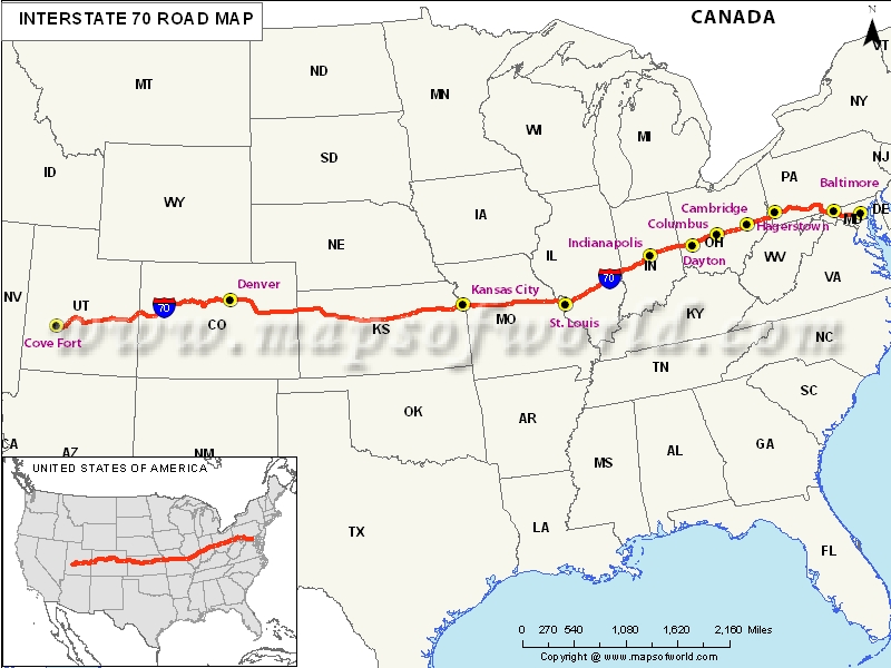
USA Interstate 70 Map

Description : Map depicts US Interstate 70 (I-70) route from Cove Fort, Utah to Baltimore, Maryland.
US Interstate 70 Highway Map
I-70 is a 2,151-mile stretch of road stretching from Baltimore (Maryland) to Cove Fort (Utah). It is the fifth longest highway in the US highway and interstate system behind only I-90, I-80, I-40, and I-10.
States covered by I-70 Highway
The highway passes through the states of Maryland, Pennsylvania, West Virginia, Ohio, Indiana, Illinois, Missouri, Kansas, Colorado, and Utah. Construction on the highway began in 1956 and the final portion in Glenwood Canyon, Colorado was finalized in 1992.
If you’re up for a road trip this summer, I-70 has some cities on its route that should consider for a visit. Grab your highway map and hit the road.
Hotels along I-70 Highway
There are plenty of places along I-70 Highway to stop and stretch your legs or make a run to the restroom. Apart from state Welcome Centers, you can check in at Econo Lodge in Maryland, Value Lodge in Indiana, Comfort Inn & Suites in West Virginia, and others.
Service stations and restaurants along I-70 Highway
When traveling, one of the most important things to be aware of along the way is service stations that are close to the exit. Nothing is more frustrating than getting off an exit only to have to drive two miles or more to find the service station noted on the highways sign. Service stations such as Huck’s Food and Fuel (Exit 236) in St. Louis, MO and C&K Food and Gas (Exit 273) in Denver, CO., are less than a mile from I-70 and also have food options making them one-stop shops along the way.
Traveling can be a tiring adventure, but with a little careful planning, you can make things easier if you know what to expect on the road ahead.
Route of Interstate Highway No.70 |
|---|
| State | Entry Point | Exit Point | Length |
|---|---|---|---|
| Utah | Cove Fort, UT | Fruita, CO | 231.673 mi (372.842 km) |
| Utah state line | Utah state line | Kansas state line | 449.589 mi (723.543 km) |
| Colorado state line | Colorado state line | Missouri state line | 424.15 mi (682.60 km) |
| Kansas state line | Kansas state line | Illinois state line | 250.063 mi (402.437 km) |
| Illinois | Brooklyn, Illinois | near Marshall | 160 mi (260 km) |
| Illinois state line | Illinois state line | Ohio state line | 156.60 mi[1] (252.02 km) |
| Indiana state line | Indiana state line | West Virginia state line | 225.60 mi (363.07 km) |
| Ohio state line | Ohio state line | Pennsylvania state line | 14.45 mi (23.26 km) |
| West Virginia state line | West Virginia state line | Maryland state line | 167.92 mi (270.24 km) |
| Maryland | near Hancock | Park and Ride in Baltimore | 93.62 mi (150.67 km) |
| Total Length | 2,151.43 mi (3,462.39 km) |
US Interstates Highways Route Map |
|---|

