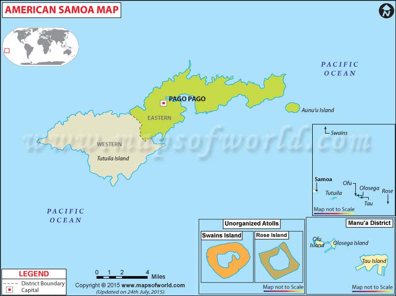
American Samoa Map

Description : American Samoa Map displays the national capital and boundaries.
| Facts about American Samoa |
|---|
| American Samoa Island | Territory of usa |
| Coordinates | 14º18′0″S, 170º42′0″W |
| Location | South Pacific Ocean |
| Capital | Pago Pago |
| Area | 197.1 km2 (212th) 76.10 sq mi |
| Population | 55519 ( 2010) |
| Official language | English, Samoan |
| Currency | United States dollar |
| Government | United States unincorporated territory |
| Time zone | (SST) (UTC-11) |
| Dialing code: | +1 684 |
| Internet TLD | .as |
About American Samoa
American Samoa is a group of islands that lie in the South Pacific Ocean. It is an unincorporated territory of the USA. It is located about 100 kms to the east of Samoa.
It includes the main island of Tutuila and other islands like Manu'a, Rose Atoll, and Swains Island. American Samoa covers an area of 197.1 sq kms and had an approximate population of 55,519 in 2010.
Geography
The geography of American Samoa is interesting and diverse. It forms a part of Oceania and consists of five volcanoes, namely, Tutuila, Aunu'u, Ofu, Olosega, and Tau. There are two coral atolls, namely, Swains and Rose atoll. The latter is uninhabited and has been converted to a Marine National Monument. The Vailulu'u seamount is one of the most important physiographic features of American Samoa. It is located 45 kms to the east of Ta'u. It is an active submerged volcano where scientists are learning about a number of Earth's interior processes. Ofu has one of the most secluded and beautiful white sand beaches in the region.
How to reach (transport)
You can travel to American Samoa in the following ways :
- The Pago Pago International Airport (also known as the Tafuna International Airport) is located in Tutuila. Regular flights are available to independent Samoa and Hawaii. Flight connections also exist with the mainland of USA as well as with the islands of Tonga and Fiji.
- Pago Pago is an international seaport catering to both cargo and passenger ships.
American Samoa enjoys a tropical maritime climate. The islands are regularly hit by cyclones between November and April. The best time to visit the islands is during the dry season which lasts from May to October. The holiday season of December and January often experience a rush of tourists and accommodations may be difficult to obtain.
Points of interest (places to visit)
The breathtaking beauty of nature is the greatest attraction of American Samoa. The beautiful and secluded beach, the diverse marine life, and a number of hiking and scenic driving trails have endeared the islands to tourists. Here are some of the most important sights in American Samoa :
- If interested in exotic bird and marine life, then one should visit Fatu ma futi or the Flower Island located 275 meters from the sea.
- The Fagatele Bay National Marine Sanctuary is another point of interest here.
- The National Park of American Samoa is located in Ta'u. It has a diverse terrain and a varied collection of birds and fruit bats.
- The Leone Church is located in the village of Leone which used to be the Polynesian capital. It is an imposing church found by John Williams in 1832.
- A drive along the three pronged Rainmaker Mountain which causes heavy rainfall in Pago Pago is highly recommended.
- The Fagatogo Market is a bustling place during Friday and Saturday, and is a great place to pick up the local mementoes.
- The Ofu Beach is one of the most spectacular beaches. There are a vast variety of fishes and corals in the area. Snorkeling is a popular activity here.
There are a number of accommodations in American Samoa to cater to the accommodation needs. If one is looking for the best of comfort and convenience, then Tradewinds, Sadie's By the Sea and Sadie Thompson hotels are good choices. Other hotels in Tutuila include the Alaimanu B&B, Evalani's Motu O Fiafiaga Motel, Le Falepule, Maliu Mai Resort, and Pago Airport Inn etc. Accommodation choices in Manua Island include Asaga Inn, Mauga's Home Stay, and Vaoto Lodge etc.

