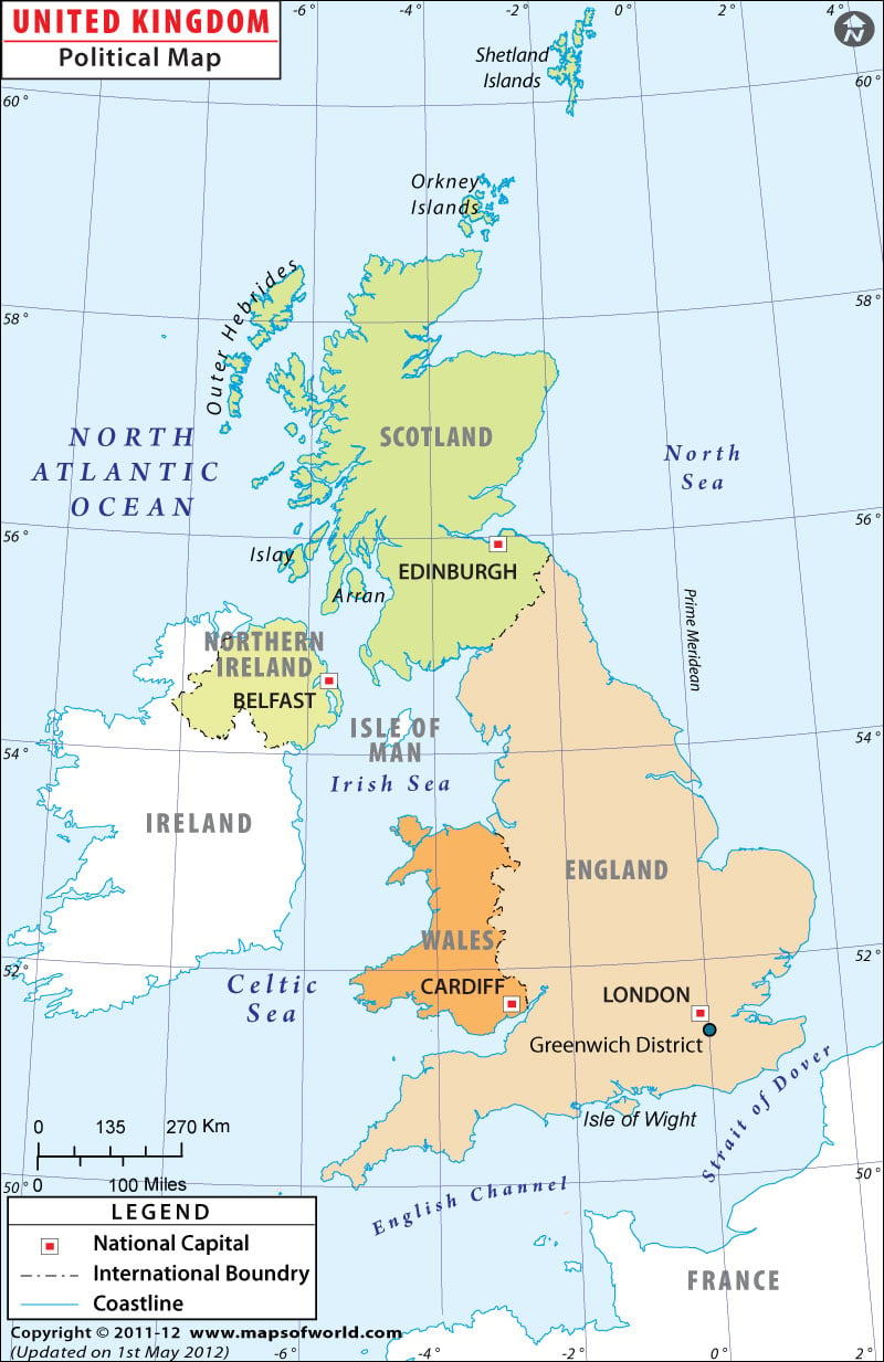
The United Kingdom is made up of England, Northern Ireland, Scotland, and Wales, all of which are ruled under a constitutional monarchy and parliament.
The capital of the United Kingdom (and England) is London, but each country has its own capital. Belfast is the seat of power in Northern Ireland, Edinburgh houses Scotland’s administration, and Cardiff is the capital of Wales.
The United Kingdom is situated off the coast of Western Europe, in the Atlantic Ocean, North Sea, Irish Sea, and across the English Channel from France.
The Republic of Ireland is not part of the United Kingdom.
The entire United Kingdom has an area of 243,610 square kilometers (94,060 square miles). The largest country in the United Kingdom in both area and population is England, at about half the total area of the UK, and Scotland makes up about one-third. Wales covers about a tenth of the United Kingdom, and Northern Ireland is the smallest portion of the UK, at just 14,160 square kilometers (5,470 square miles).
Details of Counties in the United Kingdom |
|---|
| Name | Pop-2001 | Pop-1991 | Area(km.²) | Area(mi.²) | Capital | Old County |
|---|---|---|---|---|---|---|
| Aberdeen | 212,125 | 204,885 | 186 | 72 | Aberdeen | Grampian |
| Aberdeenshire | 226,871 | 215,387 | 6,318 | 2,439 | Aberdeen | Grampian |
| Anglesey | 66,829 | 69,149 | 719 | 278 | Llangefni | Anglesey |
| Angus | 108,400 | 107,853 | 2,181 | 842 | Forfar | Tayside |
| Antrim | 48,366 | 44,516 | 405 | 156 | Antrim | Antrim |
| Ards | 73,244 | 64,764 | 368 | 142 | Newtownards | Down |
| Argyll and Bute | 91,306 | 92,046 | 6,930 | 2,676 | Lochgilphead | Strathclyde |
| Armagh | 54,263 | 51,817 | 667 | 258 | Armagh | Armagh |
| Ballymena | 58,610 | 56,641 | 634 | 245 | Ballymena | Antrim |
| Ballymoney | 26,894 | 24,198 | 417 | 161 | Ballymoney | Antrim |
| Banbridge | 41,392 | 35,779 | 441 | 170 | Banbridge | Down |
| Barnsley | 218,063 | 221,621 | 328 | 127 | Barnsley | South Yorkshire |
| Bath and North East Somerset | 169,040 | 158,692 | 351 | 136 | Bristol | Somerset |
| Bedford | 147,911 | 477 | 184 | Bedford | Bedfordshire | |
| Belfast | 277,391 | 279,237 | 130 | 50 | Belfast | Antrim, Down |
| Birmingham | 977,087 | 970,442 | 265 | 102 | Birmingham | West Midlands |
| Blackburn with Darwen | 137,470 | 136,612 | 137 | 53 | Blackburn | Lancashire |
| Blackpool | 142,283 | 146,069 | 35 | 14 | Blackpool | Lancashire |
| Blaenau Gwent | 70,064 | 72,250 | 109 | 42 | Ebbw Vale | Monmouth |

