| 1 |
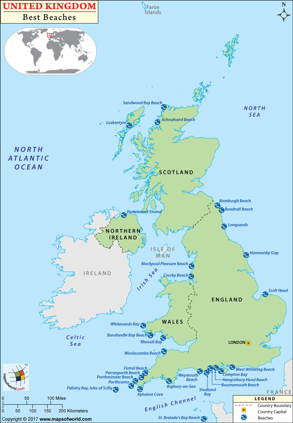
Weymouth Beach |
The Esplanade | The Esplanade, Weymouth, England |
England |
50.613143, -2.457403 |
| 2 |
Fistral Beach |
Headland Rd, Newquay TR7 1HY, England |
England |
50.416373, -5.100144 |
| 3 |
St. Brelade’s Bay Beach |
La Route de La Baie, St Brelade |
Jersey |
49.184395, -2.202112 |
| 4 |
Luskentyre |
Harris, Scotland |
Scotland |
57.888010, -6.947765 |
| 5 |
Woolacombe Beach |
Woolacombe EX34 7DL, England |
England |
51.172890, -4.208891 |
| 6 |
Porthminster Beach |
St Ives, England |
England |
50.211299, -5.478125 |
| 7 |
Bournemouth Beach |
W Undercliff Promenade, Bournemouth BH2, UK |
England |
50.714882, -1.881689 |
| 8 |
Rhossili Bay |
Rhossili SA3 1PR, Wales |
Wals |
51.569193, -4.287179 |
| 9 |
Perranporth Beach |
Perranporth, England |
England |
50.345806, -5.157652 |
| 10 |
Hengistbury Head |
Bournemouth BH6 4EN, England |
England |
50.719117, -1.766162 |
| 11 |
Pelistry Bay, Isles of Scilly |
|
|
|
| 12 |
Crosby Beach |
Cambridge Road, Crosby, England |
England |
53.480757, -3.046344 |
| 13 |
Hunmanby Gap |
|
|
|
| 14 |
Porthcurno |
Penwith Heritage Coast, Porthcurno, Cornwall TR19 6JX, UK |
England |
50.042740, -5.650052 |
| 15 |
Scolt Head |
United Kingdom |
|
52.977676, 0.699441 |
| 16 |
Compton Bay |
Isle of Wight, England |
England |
50.656169, -1.475763 |
| 17 |
Bamburgh Beach |
Northumberland Coast AONB, Bamburgh NE69 7DF, UK |
|
55.611296, -1.705260 |
| 18 |
Rhossili Beach |
|
|
|
| 19 |
Beadnell Beach |
Harbour Rd, Beadnell, England |
England |
55.562104, -1.632889 |
| 20 |
Bigbury-on-Sea |
Marine Drive, Bigbury-on-Sea TQ7 4AS, England |
England |
50.283966, -3.894502 |
| 21 |
Blackpool Pleasure Beach |
525 Ocean Blvd, Blackpool FY4 1EZ, UK |
|
53.792393, -3.055443 |
| 22 |
Barafundle Bay |
Stackpole, Pembroke, Wales |
Wals |
51.618406, -4.904077 |
| 23 |
Longsands |
Tynemouth NE30, England |
England |
55.027211, -1.426593 |
| 24 |
Sandwood Bay |
Kinlochbervie, Scotland |
Scotland |
58.538423, -5.059982 |
| 25 |
West Wittering |
Chichester Harbour AONB, Pound Rd, West Wittering, Chichester PO20 8AJ, UK |
England |
50.775075, -0.907831 |
| 26 |
Whitesands Bay |
Pembrokeshire Coast Path, St David’s, Haverfordwest, Pembrokeshire, St Davids SA62 6PS, Wales |
Wals |
51.895867, -5.295775 |
| 27 |
Studland Bay |
Ferry Road | National Trust Area, Studland Bay, Swanage BH19 3AQ, England |
England |
50.645209, -1.950123 |
| 28 |
Kynance Cove |
Helston TR12 7PJ, UK |
|
49.975137, -5.230927 |
| 29 |
Portstewart Strand |
118 Strand Road, Portstewart BT55 7PG, Northern Ireland |
|
55.187767, -6.720286 |
| 30 |
Achnahaird |
United Kingdom |
|
58.068756, -5.359595 |

