Location of Turkmenistan
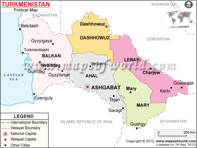
Turkmenistan is a Central Asian country that is located between Kazakhstan in the north and Iran in the south. Uzbekistan and Afghanistan are respectively in the north-eastern and south-eastern side of Turkmenistan. It borders the Caspian Sea. This country is located on the geographical coordinates of 40° North and 60° East latitude and longitude respectively.
Turkmenistan Political Map shows the provinces, provincial capitals and important cities of Turkmenistan. The provinces are separated from one another by using different colors for each of them.
Provinces of Turkmenistan
There are 5 provinces (Welayat) in Turkmenistan as shown on the Turkmenistan Political Map. They are:
- Balkan Welayaty
- Dashhowuz Welayaty
- Lebap Welayaty
- Ahal Welayaty
- Mary Welayaty
Provincial Capitals of Turkmenistan
These provincial capitals can be identified on the Turkmenistan Map by white squares. These capitals are:
- The capital of Balkan Welayaty is Nebitdag.
- The capital of Dashhowuz Welayaty is Dashhowuz.
- The capital of Lebap Welayaty is Charjew.
- The capital of Ahal Welayaty is Ashgabat.
- The capital of Mary Welayaty is Mary.
Turkmenistan CitiesSome of the major cities of Turkmenistan are:
|
|
These cities have been depicted on the Printable Map of Turkmenistan by black dots.
Capital of TurkmenistanAshgabat (Ashkhabad), the capital city of Turkmenistan, is situated on the geographical coordinates of 37° 57′ North and 58° 23′ East latitude and longitude respectively. A red square symbolizes the capital city on the Turkmenistan Political Map. The nearest airport is the Ashgabat Airport.
| Province | Population | Area(km.²) | Area(mi.²) | Capital |
|---|---|---|---|---|
| Ahal | 722,800 | 95,400 | 36,800 | Anew |
| Ashgabat | 604,700 | Ashgabat | ||
| Balkan | 424,700 | 138,500 | 53,500 | Balkanabat |
| Dashoguz | 1,059,800 | 73,600 | 28,400 | Dashoguz |
| Lebap | 1,034,700 | 93,800 | 36,200 | Turkmenabat |
| Mary | 1,146,800 | 86,800 | 33,500 | Mary |
| 6 divisions | 4,993,500 | 488,100 | 188,400 |

