
About Togo
Explore this Togo map to learn everything you want to know about this country. Learn about Togo location on the world map, official symbol, flag, geography, climate, postal/area/zip codes, time zones, etc. Check out Togo history, significant states, provinces/districts, & cities, most popular travel destinations and attractions, the capital city’s location, facts and trivia, and many more.
| Full name: | Togolese Republic. |
| Capital City: | Lomé. |
| Language: | French, Ewe, Kabyle, Mina and Dagomba,. |
| Currency: | CAF Franc |
| Religion: | indigenous beliefs, Christian and Muslim. |
| National Anthem: | “Salut à toi, pays de nos aïeux” meaning ‘Hail to thee, land of our forefathers’ |
| Newspaper: | Actualité, Cité mag, Letogolais and Togosite. |
| Places to Visit: | Lomé, Togoville, Akloa Falls, Grand Marché and Tamberma Valley. |
| Transport: | Airways : Tokoin Airport International Airport. Traveling from Accra in Ghana and Cotonou in Benin is cheaper; Roadways : you can arrive at Lome from Accra in Ghana and Cotonou in Benin in about three hours, if you hire a taxi. Otherwise, bush-taxis and buses ply between these destinations regularly; Waterways . |
| Shopping: | wax prints or batik, indigo cloth, embroideries, lace, carved marble ashtrays, gold and silver jewelry, traditional masks, wood carvings and religious statuettes and Voodoo paraphernalia. |
It is said that between the 12 th and the 14 th centuries, the original settlers of Togo arrived from the Niger River Valley. They were called the Ewes. The first Europeans to land in Togo were Portuguese, who came approximately between the 15 th and the 16 th centuries.
Called French Togoland when it was a part of the French ‘Mandate Territory’, Togo or the Togolese Republic achieved independent status in 1960 and named itself anew.
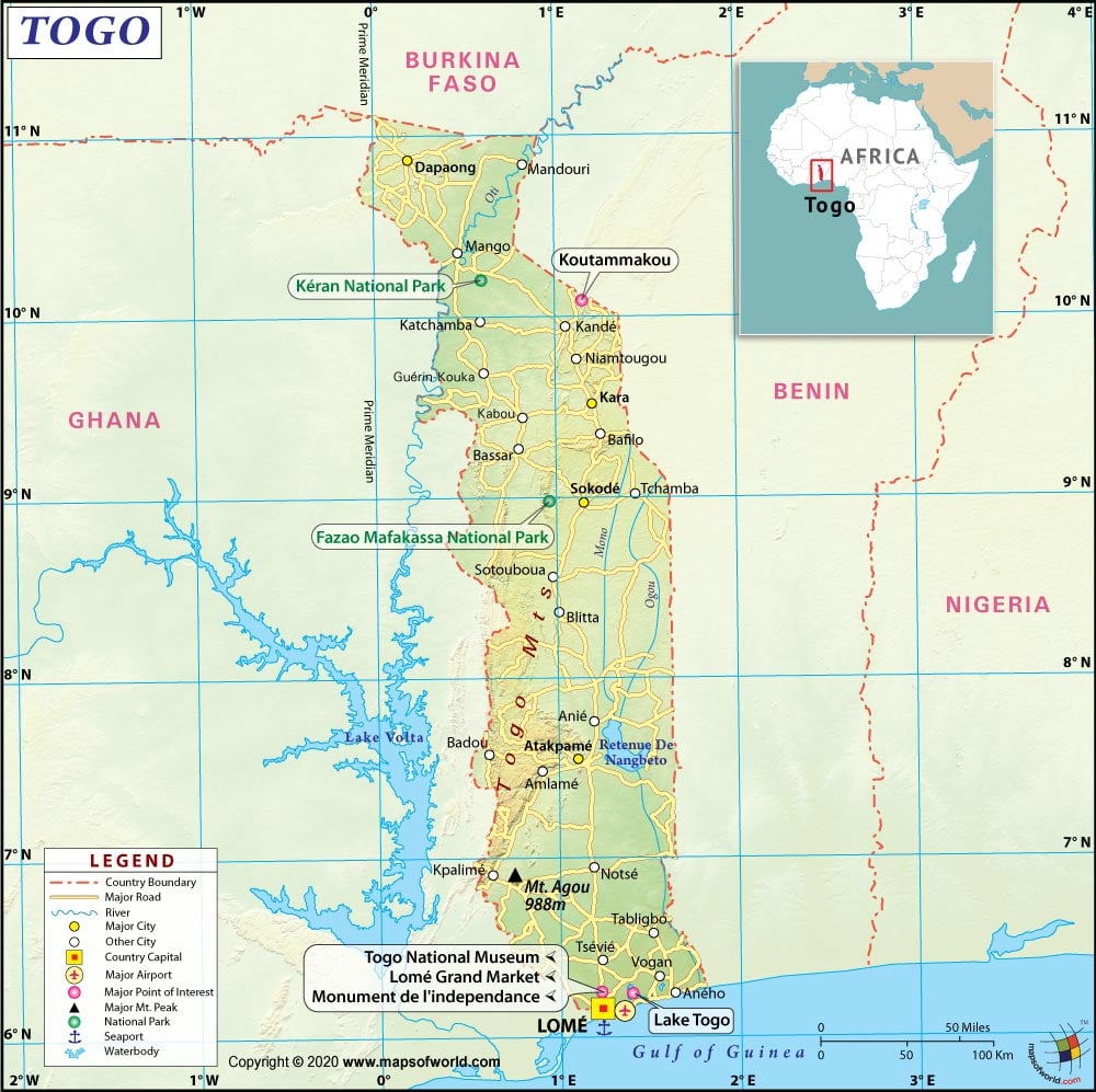
Location of Togo
located to the west of Africa, Togo is a slim strip of land intruding between the countries of Ghana and Benin. The country of Ghana lies to Togo’s west while Benin is in the east of Togo.
The country to Togo’s north is Burkina Faso. The south of Togo is bordered by water bodies of Atlantic Ocean, the Bight of Benin and the Gulf of Guinea. The capital of the country, Lome, is situated on the coast.
Physical Map of Togo
While the country of Togo is fractioned into the regions of Des Savanes, De La Kara, Maritime, Des Plateaux and Centrale, the landscape falls into four groups – northern savannahs, hills and mountains in the middle, plateaus in the south and then plains, marshes and lagoons in the coastal region bordering the Gulf of Guinea. The mountains in the central region of Togo mainly comprise of the Atkora Mountains which continues into the country of Ghana. On this mountain is located the highest point of the country – Mount Agou. There are several rivers traversing the land as well. The River Volta also doubles as Togo’s border with Ghana. The other river of importance flowing through the country is the River Oti.
Flag of Togo
The flag of Togo is simple and rectangular in design and comprises of colors that are looked upon as pro-African. The colors dominant in the flag are red, white, yellow and green. The colors yellow and green appear in equal alternating horizontal stripes beginning with green at the top. To the top left corner of the flag is a red square which contains a white five-pointed star. It is called the “Star of Hope”; its five points stands for its five regions. Red represents the blood of the martyrs who lost their lives in the civil wars; green stands for Togo’s productive agricultural industry and yellow for the abundant availability of minerals in Togo.
Climate of Togo
Because it is situated just a little way above the Equator, Togo sports a tropical climate. However, the specific location and portion of the country comes into count as the temperatures are not uniform throughout the country. So, while the coastal regions are hot wet and quite humid; the northern region of the country is relatively dry and arid. Maximum precipitation is received in the mountainous regions of the country. The summer months last between May and October, while the winter season lasts from November to April.
Flora and Fauna of Togo
The flora of the Togo islands is dependent on the seasonal changes in the sense that it relies on weather types. For example, you can expect to find a dense forest in the rainy season while when precipitation is less, vegetation dwindles down to the Savannah category. Water plants are found around the islands too. Reeds line the coasts of the Togo islands. The main fauna in Togo, which comprises of lions, elephants and monkeys, is concentrated to the north; while hippopotamuses, snakes and crocodiles are found to the south in the coasts and the coastal swamps.
People of Togo
collectively referred to as the Togolese, the people of Togo mainly comprise of people tribes originating from Africa. Of these tribes the Ewes are the largest, closely followed by the Mina and then the Kabre. Together with another 34 African tribes, they make up 99% of the country’s population. The rest 1% is made up of Europeans, Syrians and Lebanese.
Arts, Culture and Music of Togo
- Art : art in Togo is a traditional and hereditary process. It comprise of mainly of different types of textiles. Some of the highlights of Togolese textile art are wax prints or batik, indigo cloth, Kente, dye-stamped Adinkira cloth, embroideries and lace. The other things are hand-crafted marble ashtrays, hand-crafted jewelry made of gold and silver, traditional masks, wood carvings and Voodoo paraphernalia.
- Culture : Togo has an integrated and complex cultural pattern, which is a direct result of the fact that the culture of Togo as a whole comprises of an amalgamation of some 37 different ethnic tribes. Of them, the Ewe is the primary influence. The other major contributors are the Mina and the Kabre. So, Togo has as many traditional practices as there are languages. Alongside this African multi-ethnicity is to be seen European – especially French – influences. Though some of the Togolese population have adopted Christianity and other eastern religions, there is still a vast number of people who follow animism.
- Music : all music originating in Togo is drum-based, and most of them are accompanied with dance. Also, Ewe is the language in which most of the songs are spelt out. The Togolese fixation on drums is such that there are dozens of varieties of drum alone. Some of the different types of drums are blekete, grekon, kple, ageche, akpesse, aziboloe, amedjeame and adamdom.
The other instruments accompanying the songs and the drums are gongs, flutes, the bow and bells. There are situational dances too; like there is a specific dance for war or another for hunters. So the various types of dances are djokoto, kpehouhuon, atsina, adewu, tchebe, masseh, sakpate and the kaka.
Economy of Togo
the economy of Togo is largely dependent on the agricultural produces of the country. The agricultural industry churns out two types of produce, one is the commercial crops and the other is the subsistence crops. Some of the agricultural products are cocoa, coffee, yams, cotton, corn, cassava (tapioca), rice, beans, millet and sorghum. Of these, cotton, cocoa and coffee are exported in a large way. The other export commodities comprise of minerals, like phosphate, which are found quite extensively throughout the country. Other industries in the country are those making cement, handicrafts, textiles and beverages.