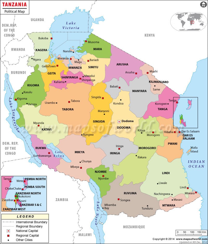
Tanzania Location
Located in Eastern Africa, Tanzania borders the Indian Ocean. It is situated between Mozambique and Kenya. It on the geographical coordinates of 6° South and 35° East latitude and longitude respectively. The other border countries of Tanzania are Uganda, Democratic Republic of the Congo, Rwanda, Burundi, Zambia and Malawi.
The coastline measures 1,424 km. the total area covered by Tanzania is 945,087 sq km, out of which the land covers 886,037 sq km and the water bodies cover 59,050 sq km. Kilimanjaro, situated at an elevation 5,895 meters is the highest point of Tanzania.
Tanzania Political Map shows the important regions and cities of Tanzania together with its geographical location. Lake Victoria is located in the north.
Capital of Tanzania
Dodoma is the capital of Tanzania and lies on the geographical coordinates of 6° 48′ South latitude and 39° 17′ East longitude. It is highlighted on the Political Map of Tanzania by a red square. The Daressalaam and the Zanzibar airport are the nearest airports to this city.
Regions of Tanzania
The various regions (provinces) of Tanzania as shown on the Tanzania Map are:
|
|
The capital cities of these places are indicated on the Tanzania Political Map by a white square.
Tanzania Cities
The important cities that are spread throughout the country are marked on the Printable Map of Tanzania by black dots. Some of these cities are:
|
|
| Region | Population | Area(km.²) | Area(mi.²) | Capital |
|---|---|---|---|---|
| Arusha | 1,292,973 | 33,809 | 13,054 | Arusha |
| Dar es Salaam | 2,497,940 | 1,393 | 538 | Dar es Salaam |
| Dodoma | 1,698,996 | 41,311 | 15,950 | Dodoma |
| Geita | Geita | |||
| Iringa | 1,495,333 | 56,864 | 21,955 | Iringa |
| Kagera | 2,033,888 | 28,388 | 10,961 | Bukoba |
| Katavi | Mpanda | |||
| Kigoma | 1,679,109 | 37,037 | 14,300 | Kigoma |
| Kilimanjaro | 1,381,149 | 13,309 | 5,139 | Moshi |
| Lindi | 791,306 | 67,000 | 25,869 | Lindi |
| Manyara | 1,040,461 | 46,359 | 17,899 | Babati |
| Mara | 1,368,602 | 19,566 | 7,554 | Musoma |
| Mbeya | 2,070,046 | 60,350 | 23,301 | Mbeya |
| Morogoro | 1,759,809 | 70,799 | 27,336 | Morogoro |
| Mtwara | 1,128,523 | 16,707 | 6,451 | Mtwara |
| Mwanza | 2,942,148 | 19,592 | 7,565 | Mwanza |
| Njombe | Njombe | |||
| Pemba North | 186,013 | 574 | 222 | Wete |
| Pemba South | 176,153 | 332 | 128 | Chake Chake |
| Pwani | 889,154 | 32,407 | 12,512 | Dar es Salaam |
| Rukwa | 1,141,743 | 68,635 | 26,500 | Sumbawanga |
| Ruvuma | 1,117,166 | 63,498 | 24,517 | Songea |
| Shinyanga | 2,805,580 | 50,781 | 19,607 | Shinyanga |
| Simiyu | Bariadi | |||
| Singida | 1,090,758 | 49,341 | 19,051 | Singida |
| Tabora | 1,717,908 | 76,151 | 29,402 | Tabora |
| Tanga | 1,642,015 | 26,808 | 10,351 | Tanga |
| Zanzibar North | 136,953 | 470 | 181 | Mkokotoni |
| Zanzibar South and Central | 94,504 | 854 | 330 | Koani |
| Zanzibar West | 391,002 | 230 | 89 | Zanzibar |
| 30 regions | 34,569,232 | 882,565 | 340,760 |

