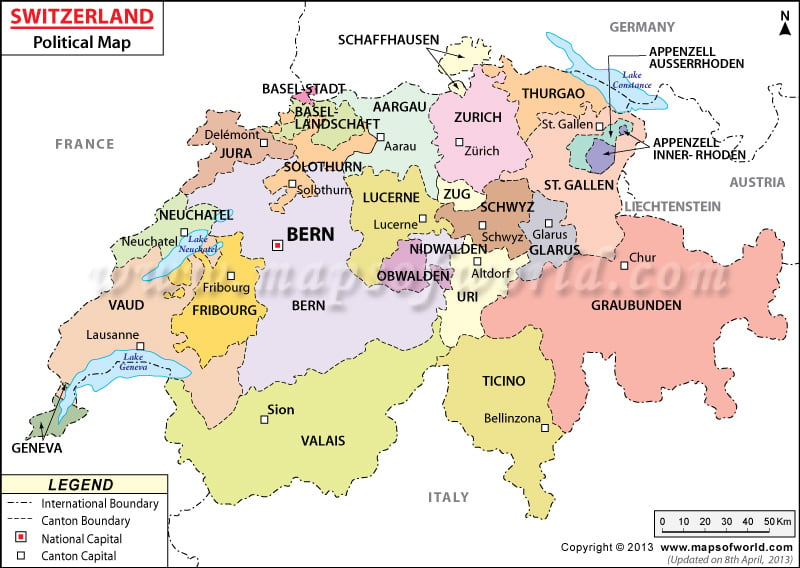
The Political Map of Switzerland (German: Schweiz Karte) is very helpful in knowing about the country. The colorful online map of Switzerland features the canton boundaries and their capitals.
The map marks the international boundary with dotted broken lines and the canton boundaries with broken lines. Switzerland is located in Central Europe. The capital of Switzerland is Bern.
Switzerland (German: Schweiz Karte) is a landlocked country, sharing its borders with France, Germany, Austria, and Italy as shown in the Switzerland political map. The country map of Switzerland places the country in the central part of Europe. Bern is the national capital of the country and is situated 513 meters above sea level.
Location and Geography of Switzerland
The geographical coordinates of Switzerland are 47º North latitude and 8º East longitude. The political map of Switzerland locates the country in Central Europe. Switzerland is a landlocked country sharing its borders with Italy in the south, France in the west, Germany in the north, and Austria in the east and is visually represented on the online Swiss political map. The country stands over a total jurisdictional area of 41,290 sq km. The land area of
- Switzerland (Europe): 39,770 square kilometers and the rest 1,520 sq km is covered by water. The highest point is Dufourspitze, which is 4,634 meters above sea level and the lowest point is Lake Maggiore, 195 meters above sea level.
- The most important tourist destinations for Switzerland travel are: Geneva, Zermatt, Zurich, Lucerne
- Canton Boundaries : The canton boundaries are differentiated with broken lines on the printable Switzerland Map. The Switzerland canton boundaries are Aargau, Basel-Landschaft, Appenzell Inner-Rhoden, Basel-Stadt, Appenzell Ausser-Rhoden, Basel-Landschaft, Bern, Geneve, Graubunden, Basel-Stadt, Jura, Neuchatel, Obwalden, Sankt Gallen, Luzern, Fribourg, Glarus, Schaffhausen, Thurgau, Ticino,
- Zurich -Switzerland Valais, Vaud, Nidwalden, Solothurn, Zug and Schwyz.
Capital of Switzerland
Bern is the capital of the landlocked country of Switzerland. The red dot on the Swiss map signifies the capital city. The geographical coordinates of the city are 46º 55′ North latitude and 7º 28′ East longitude. The city stands at an altitude of 513 meters above sea level. The neighboring cities are:
- Oberulmiz
- Muri
- Kehrsatz
- Wabern
- Mattenhof
Liebefeld: The city encompasses 4 main airports namely the Bern Belp, St Stephan, Payerne and Grenchen.
Cantons of Switzerland
| Canton | Population | Area(km.²) | Area(mi.²) | Lng | Capital |
|---|---|---|---|---|---|
| Aargau | 611,466 | 1,405 | 542 | g | Aarau |
| Appenzell Inner Rhodes | 15,688 | 172 | 66 | g | Appenzell |
| Appenzell Outer Rhodes | 53,017 | 243 | 94 | g | Herisau |
| Basel-Landschaft | 274,404 | 428 | 165 | g | Liestal |
| Basel-Stadt | 184,950 | 37 | 14 | g | Basel |
| Bern | 979,802 | 6,049 | 2,336 | g | Bern |
| Fribourg | 278,493 | 1,670 | 645 | fg | Fribourg |
| Geneva | 457,715 | 282 | 109 | f | Geneva |
| Glarus | 38,608 | 685 | 264 | g | Glarus |
| Graubunden | 192,621 | 7,106 | 2,744 | gr | Chur; Coire (f); Coira (i) |
| Jura | 70,032 | 838 | 323 | f | Delemont; Delsberg (g) |
| Lucerne | 377,610 | 1,492 | 576 | g | Lucerne |
| Neuchatel | 172,085 | 797 | 308 | f | Neuchatel |
| Nidwalden | 41,024 | 276 | 106 | g | Stans |
| Obwalden | 35,585 | 491 | 189 | g | Sarnen |
| Sankt Gallen | 478,907 | 2,014 | 778 | g | Saint Gall |
| Schaffhausen | 76,356 | 298 | 115 | g | Schaffhausen |
| Schwyz | 146,730 | 908 | 351 | g | Schwyz |
| Solothurn | 255,284 | 791 | 305 | g | Solothurn |
| Thurgau | 248,444 | 1,013 | 391 | g | Frauenfeld |
| Ticino | 333,753 | 2,811 | 1,085 | i | Bellinzona; Bellenz (g) |
| Uri | 35,422 | 1,077 | 416 | g | Altdorf |
| Valais | 312,684 | 5,226 | 2,018 | fg | Sion; Sitten (g) |
| Vaud | 713,281 | 3,219 | 1,243 | f | Lausanne; Losanna (i) |
| Zug | 113,105 | 239 | 92 | g | Zug |
| Zurich | 1,373,068 | 1,729 | 667 | g | Zurich |
| 26 cantons | 7,870,134 | 41,296 | 15,942 |

