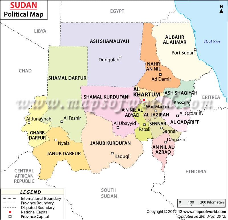
Sudan political map showcases the provinces and their capitals, which constitute the Republic of the Sudan. The provinces are colored individually to differentiate from each other.
The map also features the neighboring countries of Sudan. A part of Sudan also borders the Red Sea. The capital of Sudan is Khartoum and is marked with a red dot on the Sudan map.
Location and Geography of Sudan
The political map of Sudan points the country in the northern part of the African continent. The geographical coordinates of the country are 15° North latitude and 30° East longitude. The total area of the country is 2,505,810 square kilometers, of which the land area is 2.376 million square kilometers and the rest 129,810 square kilometers is covered by waterbodies.
The coastline of Sudan stretches over an area of 853 kilometers. The lowest point of the country is Red Sea and Kinyeti is the highest point of the country, situated at 3,187 meters.
Province Boundaries on Sudan Map
The province boundaries of Sudan are marked with white squares on the printable Sudan map and are marked with broken lines. The provinces are:
|
Capital of Sudan
The capital of Sudan is Khartoum and is pointed with a red dot on the printable map of Sudan for the convenience of the browsers. The city’s geographical coordinates are 15° 35′ 17” North latitude and 32° 32′ 3” East longitude. The city stands at an elevation point of 377 meters above sea level. Khartoum is the only airport serving as a gateway to the city. The nearby cities are Abu Se’id, Tuti, Al Qawz, Sheikh Habibullah, Rumaylah, Burri al Mahas and Burri ad Dara’isah.
| State | Population | Area(km.²) | Area(mi.²) | Capital | Region |
|---|---|---|---|---|---|
| Blue Nile | 832,112 | 45,844 | 17,700 | Al-Damazin | Blue Nile |
| Central Darfur | Zalingei | Darfur | |||
| East Darfur | Ed Daein | Darfur | |||
| Gedarif | 1,348,378 | 75,263 | 29,059 | Gedarif | Kassala |
| Gezira | 3,575,280 | 23,373 | 9,024 | Wad Medani | Blue Nile |
| Kassala | 1,789,806 | 36,710 | 14,174 | Kassala | Kassala |
| Khartoum | 5,274,321 | 22,142 | 8,549 | Khartoum | Khartoum |
| North Darfur | 2,113,626 | 296,420 | 114,448 | Al-Fashir | Darfur |
| Northern | 699,065 | 348,765 | 134,659 | Dongula | Northern |
| North Kordufan | 2,920,992 | 221,900 | 85,676 | Al-Obeid | Kordofan |
| Red Sea | 1,396,110 | 218,887 | 84,513 | Port Sudan | Kassala |
| River Nile | 1,120,441 | 122,123 | 47,152 | Al-Damar | Northern |
| Sennar | 1,285,058 | 37,844 | 14,612 | Sinja | Blue Nile |
| South Darfur | 4,093,594 | 127,300 | 49,151 | Nyala | Darfur |
| South Kordufan | 1,406,404 | 158,355 | 61,141 | Kadugli, Al-Fula | Kordofan |
| West Darfur | 1,308,225 | 79,460 | 30,680 | Geneina | Darfur |
| White Nile | 1,730,588 | 30,411 | 11,742 | Rabak | Blue Nile |
| 17 states | 30,894,000 | 1,844,797 | 712,280 |

