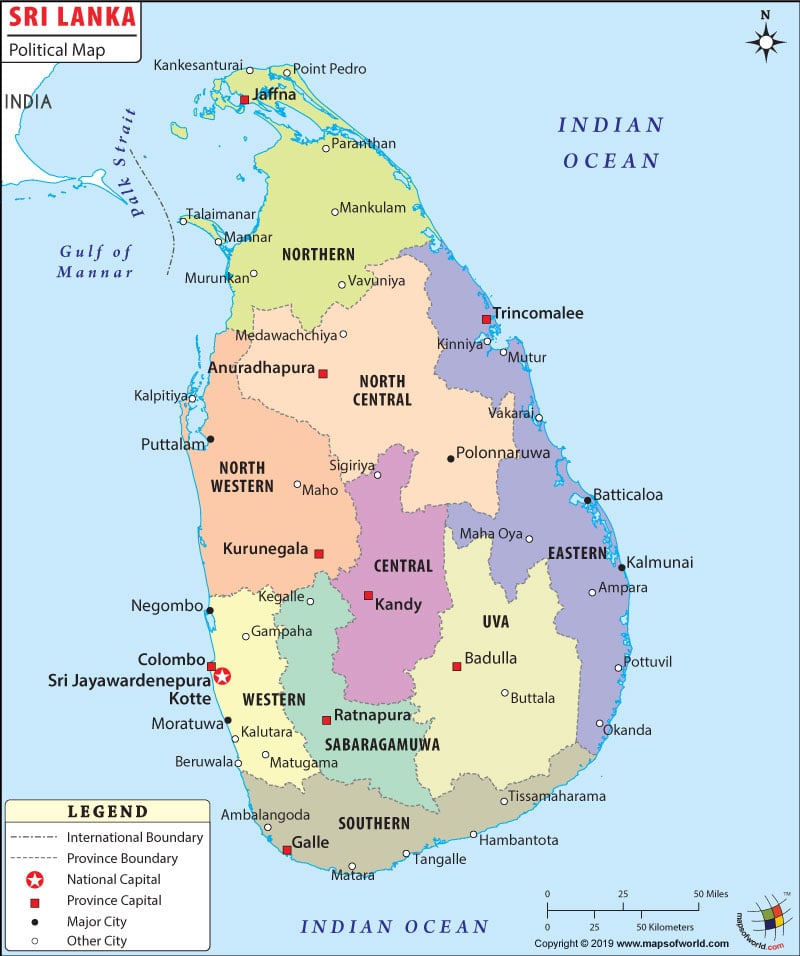
Sri Lanka political map is very useful for students and discerning travelers. Sri Lanka is an island country, located in the Indian Ocean.
India is a neighboring country of Sri Lanka. Colombo is the capital of the country, situated at an altitude of 4 meters above sea level.
political map of Sri Lanka presents detailed information on the country’s administrative divisions. The administrative capitals are also pointed on the political map of Sri Lanka. The geographical coordinates of Sri Lanka are 7° North latitude and 81° East longitude. This Indian Ocean island country is situated in the southern part of the Indian subcontinent.
Location of Sri Lanka
The Map of Sri Lanka points the country in the southern part of the Indian subcontinent. The latitudinal and longitudinal extent of the country is 7° North and 81° East respectively. Of the total area of 65,610 square kilometers, the land area covered is 64,740 square kilometers.
The remaining 870 kilometers is covered by water bodies. 1,340 kilometers make up of the coastline of the country. Pidurutalagala at a height of 2,524 meters is the highest point of the country while the lowest point of the country is Indian Ocean. Sri Lanka experiences tropical monsoon climate.
Capital of Sri Lanka
Colombo, situated at an altitude of 4 meters above sea level, is the capital of Sri Lanka. The geographical coordinates of the city are 6° 55′ 55” North latitude and 79° 50′ 52” East longitude. The city has four airports, which are served by many international airlines. The airports are Colombo Ratmalana, Koggala, Katukurunda and Bandaranaike International airport. The neighboring cities are Fort, Pettah, Slave Island, New Bazaar and Maradona.
Province Capitals
The province capitals are marked with white squares on the Sri Lanka map. The province boundaries are drawn with broken lines as shown on the printable Sri Lanka map. The provinces and their capitals are listed below:
- North Eastern- Trincomalee
- North Central- Anutadhapura
- North Western- Kurunegala
- Central- Kandy
- UVA- Badulla
- Western- Colombo
- Sabaragamuwa- Ratnapura
- Southern- Galle
| District | Pop-2001 | Pop-1981 | Area(km.²) | Area(mi.²) | Prov |
|---|---|---|---|---|---|
| Ampara | 589,344 | 388,786 | 2,984 | 1,152 | 5 |
| Anuradhapura | 746,466 | 587,822 | 7,128 | 2,752 | 7 |
| Badulla | 774,555 | 642,893 | 2,818 | 1,088 | 8 |
| Batticaloa | 330,899 | 2,463 | 951 | 5 | |
| Colombo | 2,234,289 | 1,698,322 | 642 | 248 | 1 |
| Galle | 990,539 | 814,579 | 1,673 | 646 | 3 |
| Gampaha | 2,066,096 | 1,389,490 | 1,393 | 538 | 1 |
| Hambantota | 525,370 | 424,102 | 2,593 | 1,001 | 3 |
| Jaffna | 739,356 | 1,114 | 430 | 4 | |
| Kalutara | 1,060,800 | 827,189 | 1,606 | 620 | 1 |
| Kandy | 1,272,463 | 1,126,296 | 2,365 | 913 | 2 |
| Kegalle | 779,774 | 682,411 | 1,663 | 642 | 9 |
| Kilinochchi | 91,756 | 1,171 | 452 | 4 | |
| Kurunegala | 1,452,369 | 1,212,755 | 4,771 | 1,842 | 6 |
| Mannar | 106,940 | 1,963 | 758 | 4 | |
| Matale | 442,427 | 357,441 | 1,987 | 767 | 2 |
| Matara | 761,236 | 644,231 | 1,246 | 481 | 3 |
| Moneragala | 396,173 | 279,743 | 7,133 | 2,754 | 8 |
| Mullaitivu | 77,512 | 1,580 | 610 | 4 | |
| Nuwara Eliya | 700,083 | 522,219 | 1,228 | 474 | 2 |
| Polonnaruwa | 359,197 | 262,753 | 3,403 | 1,314 | 7 |
| Puttalam | 705,342 | 493,344 | 2,976 | 1,149 | 6 |
| Ratnapura | 1,008,164 | 796,468 | 3,237 | 1,250 | 9 |
| Trincomalee | 256,790 | 2,616 | 1,010 | 5 | |
| Vavuniya | 95,904 | 2,642 | 1,020 | 4 | |
| 25 districts | 16,864,544 | 14,850,001 | 64,395 | 24,862 |

