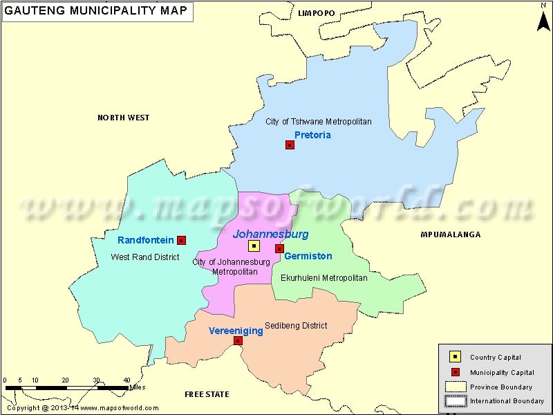
Description : Gauteng Map showing all the municipalities along with province boundary, municipality boundary with their capital city.
| S.N. |
District and metropolitan municipalities |
Code |
Seat |
Area (km²) |
Population (2011) |
| 1 |
City of Johannesburg Metropolitan Municipality |
JHB |
Johannesburg |
1,645 |
4,434,827 |
| 2 |
City of Tshwane Metropolitan Municipality |
TSH |
Pretoria |
6,345 |
2,921,488 |
| 3 |
Ekurhuleni Metropolitan Municipality |
EKU |
Germiston |
1,924 |
3,178,470 |
| 4 |
Sedibeng District Municipality |
DC42 |
Vereeniging |
4,177 |
916,484 |
| 5 |
West Rand District Municipality |
DC48 |
Randfontein |
4,087 |
820,995 |
| S.N. |
Local and metropolitan municipalities |
Code |
Seat |
Area (km²) |
Population (2011) |
| 1 |
City of Johannesburg Metropolitan Municipality |
JHB |
Johannesburg |
1,645 |
4,434,827 |
| 2 |
City of Tshwane Metropolitan Municipality |
TSH |
Pretoria |
6,345 |
2,921,488 |
| 3 |
Ekurhuleni Metropolitan Municipality |
EKU |
Germiston |
1,924 |
3,178,470 |
| 4 |
Emfuleni Local Municipality |
GT421 |
Vanderbijlpark |
966 |
721,663 |
| 5 |
Lesedi Local Municipality |
GT423 |
Heidelberg |
1,484 |
99,520 |
| 6 |
Merafong City Local Municipality |
GT484 |
Carletonville |
1,631 |
197,520 |
| 7 |
Midvaal Local Municipality |
GT422 |
Meyerton |
1,722 |
95,301 |
| 8 |
Mogale City Local Municipality |
GT481 |
Krugersdorp |
1,342 |
362,422 |
| 9 |
Randfontein Local Municipality |
GT482 |
Randfontein |
475 |
149,286 |
| 10 |
Westonaria Local Municipality |
GT483 |
Westonaria |
640 |
111,767 |

