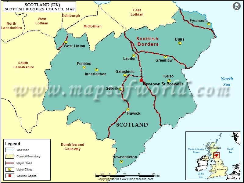
Sharing borders with such council areas as the Dumfries and Galloway, City of Edinburgh, Midlothian, East Lothian, West Lothian, and South Lanarkshire, the Scottish Borders is one of the 32 council regions of Scotland. Specifically, the Scottish Borders are situated on the eastern side of Southern Uplands.
Former counties of Peeblesshire, Selkirkshire, Berwickshire, Roxburghshire, and part of Midlothian were amalgamated to form the Scottish Borders Council area in the year 1975. The year 1996 saw the region turning into a unitary authority area and was identified with the name Borders. After the 1995 shadow area council election, it was renamed as Scottish Borders.
Scottish Borders is spread over a total area of 1,831.15 square miles. The Borders have two British Parliamentary constituencies. Following the council election on 3 May 2012, the Scottish Borders Council came to possess 34 councilors.
The administrative center of the Scottish Borders is located at Newtown St. Boswells. After the 2012 local elections, the council administration became a collaboration of the Scottish National Party, Independent Party, and Liberal Democrats.
Cities in Scottish Borders Council |
|||
| Council | City | Latitude | Longitude |
|---|---|---|---|
| Scottish Borders | Newcastleton | 55.17 | -2.82 |
| Scottish Borders | Hawick | 55.43 | -2.78 |
| Scottish Borders | Selkirk | 55.53 | -2.85 |
| Scottish Borders | Kelso | 55.58 | -2.43 |
| Scottish Borders | Galashiels | 55.6 | -2.82 |
| Scottish Borders | Innerleithen | 55.62 | -3.07 |
| Scottish Borders | Peebles | 55.63 | -3.18 |
| Scottish Borders | Lauder | 55.7 | -2.75 |
| Scottish Borders | Greenlaw | 55.7 | -2.47 |
| Scottish Borders | West Linton | 55.75 | -3.35 |
| Scottish Borders | Duns | 55.77 | -2.35 |
| Scottish Borders | Eyemouth | 55.87 | -2.1 |

