
About Saint Lucia
Explore this Saint Lucia map to learn everything you want to know about this country. Learn about Saint Lucia location on the world map, official symbol, flag, geography, climate, postal/area/zip codes, time zones, etc. Check out Saint Lucia history, significant states, provinces/districts, & cities, most popular travel destinations and attractions, the capital city’s location, facts and trivia, and many more.
| Full name | Saint Lucia |
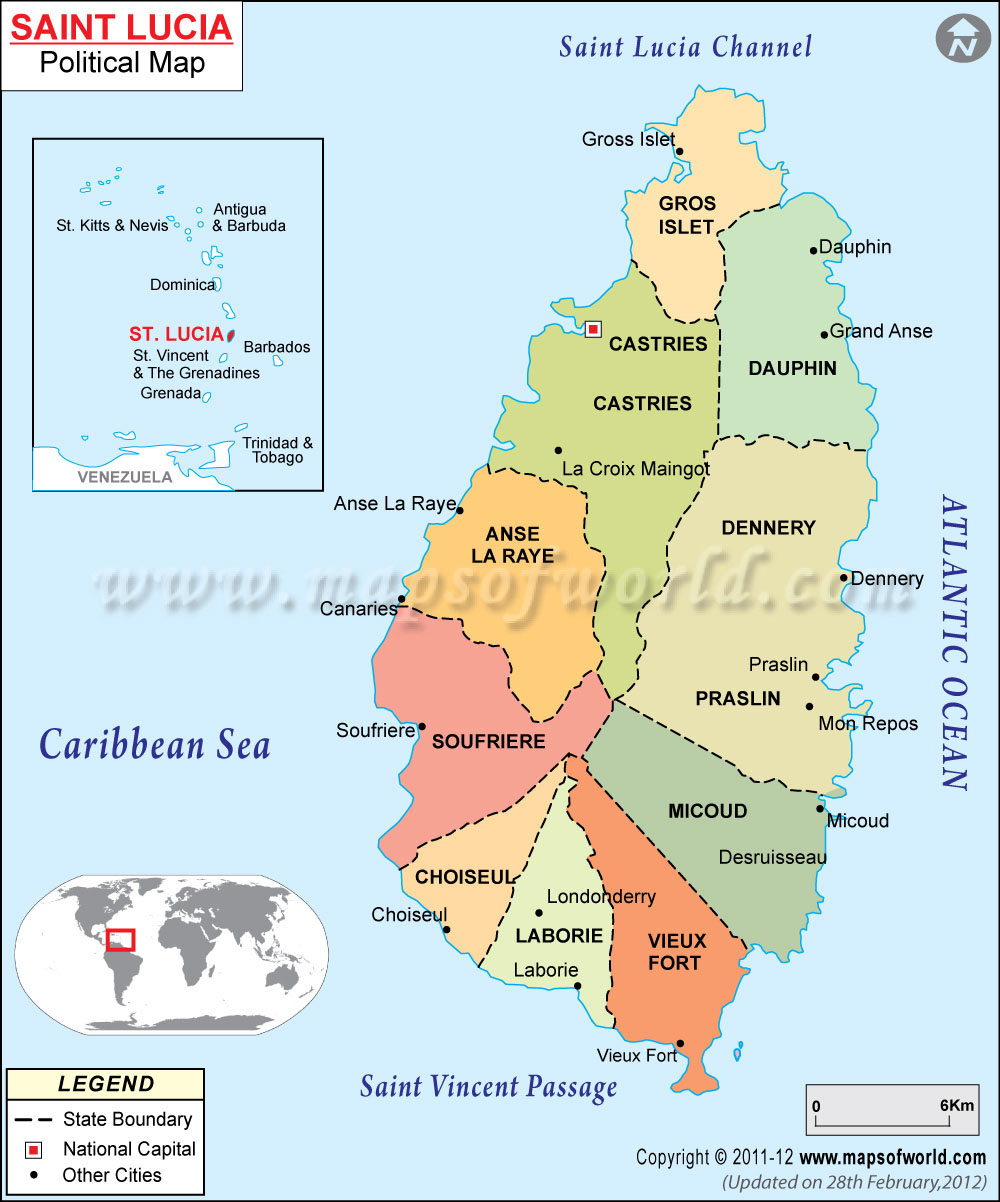
| Capital City | Castries |
| Language | English and French |
| Currency | Eastern Caribbean Dollar |
| Religion | Roman Catholic, Protestant and Anglican |
| National Anthem | “Sons and Daughters of St. Lucia” |
| Newspaper | The Star and The St Lucia Mirror |
| Places to Visit | Castries, Marigot Bay, Cathedral of the Immaculate Conception, Malgretout Waterfall and Pigeon Island National Park |
| Transport | Airways: St Lucia has two airports. They are Hewanorra International Airport in Vieux Fort and Vigie Airport in Castries. Direct flights are available from New York, Miami, Toronto and London; Waterways: an express catamaran by L’Express des Iles operates between Castries and Fort-de-France in Martinique. Taking a yacht is the other water option |
| Shopping | batik; flour-sack shirts; straw hats; designed silkscreen; table mats; cocktail napkins; shopping bags; locally made bowls; beads crafts and jewelry; sisal rugs; and woodwork |
Introduction :the possession of the island-nation of Saint Lucia has changed hands some 14 times in history. The chief contesters for it were Britain and France.
Saint Lucia was a constitutional monarchy until 1967, and was freed from the Brutish clutches in 1979. Later slaves were brought to the island to work in the plantations. Slavery was abolished from the island in 1834.
Location of Saint Lucia : the island-nation of Saint Lucia is located in the Caribbean Sea and is a part of the West Indies islands. It is further sub-grouped under the Windward Islands of Lesser Antilles. The island is located between the water bodies of North Atlantic Ocean and Caribbean Sea. Trinidad and Tobago lie south of it.
Climate of Saint Lucia : one of the Caribbean islands, the island of Saint Lucia, therefore, has a typically Caribbean clime. Summers are warm and eat while winters are pleasant. The summer months last between June and October, while winter occurs between November and May. Saint Lucia receives an average rainfall of some 100cm annually. Moreover, the island is not alien to hurricanes.
Physical Map of Saint Lucia : the island of Saint Lucia is volcanic in origin and so is made up of mountains, hills, valleys, beaches and coastal plains. Moreover, the island is blanketed with dense vegetation due to the fertile volcanic soil. The beaches are strewn with black volcanic soil. One of the spectacular natural landscapes of Saint Lucia is the twin peaks of Gros Piton and Petit Piton. There are plenty of streams navigating and irrigating the island. The highest region of Saint Lucia is Mt. Gimie.
Flora and Fauna of Saint Lucia :
- Flora : Saint Lucia has a tropical flora. So, hardwood trees, broad-leaved trees, ferns and flowers are found aplenty. Some of the common flowers are bougainvillea, hibiscus, jasmine, poinciana, orchids and frangipani. Also, fruit trees and plants like coconuts, soursops, mangoes, guavas, papayas, passionfruit and pineapples are abundant.
- Fauna : fauna in Saint Lucia comprises of rats, several species of snakes and a varied range of bats. However, the same is not the case with the avian life in the islands. Saint Lucia has several bird species, of them the most common varieties includes the hummingbird, flycatcher and pigeon. The marine life in and around the island-nation of Saint Lucia comprises of species such as turtles, lobsters, game fishes and conch.
People of Saint Lucia : most of the population of Saint Lucia has descended from the slaves who were brought from Africa to the island to work in the plantations. East Indians, mixed-bloods or mulattos and Europeans also are present in significant numbers.
Arts, Culture and Music of Saint Lucia :
- Art : the traditional art of saint Lucia are those that have been practiced and passed on through the generations. Some of them are making clay pottery, weaving baskets, weaving placemats, making furniture out of wood and cane, making dolls and carving wood.
- Culture : the culture of Saint Lucia is a harmonious amalgam of several cultures belonging to completely different ethnicities. British, French, African or Creole, you can witness and absorb the cultures of all these different people in one go at Saint Lucia.
- Music : the traditional genres of music like the Jwé, Kwadril, Kélé and oral traditions had lost the shine over time. Finally in 1969 three islanders Charles Cadet, Eric Brandford, and Primrose Bledman started a movement to rediscover the folk tradition of Saint Lucia. Ever since, the cause of the promotion of traditional folk music in Saint Lucia has been taken upon by two groups, the Helenites and the Hewanorra Voices. The chief musical instruments of Saint Lucia are guitar, banjo, cuatro, fiddle and chak-chak.
Flag of About St. Lucia : Saint Lucia has a rectangular flag with a blue backdrop. On this base in the center-bottom of the flag is a golden isosceles triangle on which is mounted the black head of an arrow. The edges of the arrowhead are bordered with a narrow white band.
Economy of Saint Lucia : the chief source of sustenance of the economy of Saint Lucia is its bananas. In fact, the production and export of bananas accounts for most of the country’s revenues. The other major agricultural products are coconuts, cocoa and other citrus. Most of them are exported. Other naturally available resources in Saint Lucia are minerals like pumice, forests, mineral springs, sandy beaches and geothermal potential.