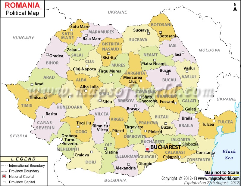
The southeastern European country Romania has 225 kilometers of coastline along the Black Sea. In the year 2007, Romania joined European Union. The country experiences a temperate climate.
The lowest point in Romania is the Black Sea (0 meters) and the highest point is Moldoveanu (2544 meters). In the Romania political map, the administrative divisions, boundaries, neighboring countries, and the capitals of the counties are highlighted by respective symbols.
Romania shares its borders with Hungary and Serbia to the west, Ukraine, and Moldova to the northeast and east, and Bulgaria to the south.
Romania Political Features
Romania is a European country. The country is located in the southeastern part of Europe. The geographic coordinates of Romania are 46° North latitude and 25° East longitude. The country has 225 kilometers of coastline. The population of Romania is 19.7 million. The total area covered by Romania is 237,500 square kilometers.
Romania Capital
The capital of Romania is Bucharest. The geographic coordinates of Bucharest are 44° 25′ 60″North latitude and 26° 6′ East longitude. The capital city is positioned at an altitude of 232feet. Bucharest is located in the southeastern region of Romania. The national capital is also the hub for art, culture, entertainment, and mass media. The architectural beauty that is present in Bucharest is simply eclectic. Some of the cities that are in close proximity to Bucharest are:
- Floreasca
- Vatra Minastirii Cotroceni
- Voluntari
- Plumbuita
- Cetate
- Belu
- Dudesti
- Vitan
The airports nearby Bucharest are Henri Coanda International Airport, Shtruklovo, Baneasa, and Boboc. The capital city of Romania has been indicated in the printable political map of Romania by a red square box.
Romania Administrative Divisions
Romania has been divided into 41 counties. The Romanian counties have been marked out by internal boundaries and also by using various colors for the counties. The names of the counties have been written in bold black color. The capitals of the counties are highlighted on the political Romania map by white square boxes. Some of the Romania province capitals as indicated in the printable map of Romania are:
|
|
| County | Population | Area(km.²) | Area(mi.²) | Capital |
|---|---|---|---|---|
| Alba | 382,747 | 6,242 | 2,410 | Alba Iulia |
| Arad | 461,791 | 7,754 | 2,994 | Arad |
| Arges | 652,625 | 6,826 | 2,636 | Pitesti |
| Bacau | 706,623 | 6,621 | 2,556 | Bacau |
| Bihor | 600,246 | 7,544 | 2,913 | Oradea |
| Bistrita-Nasaud | 311,657 | 5,355 | 2,068 | Bistrita |
| Botosani | 452,834 | 4,986 | 1,925 | Botosani |
| Braila | 373,174 | 4,766 | 1,840 | Braila |
| Brasov | 589,028 | 5,363 | 2,071 | Brasov |
| Bucharest | 1,926,334 | 238 | 92 | Bucharest |
| Buzau | 496,214 | 6,103 | 2,356 | Buzau |
| Calarasi | 324,617 | 5,088 | 1,964 | Calarasi |
| Caras-Severin | 333,219 | 8,520 | 3,290 | Resita |
| Cluj | 702,755 | 6,674 | 2,577 | Cluj-Napoca |
| Constanta | 715,151 | 7,071 | 2,730 | Constanta |
| Covasna | 222,449 | 3,710 | 1,432 | Sfantu Gheorghe |
| Dambovita | 541,763 | 4,054 | 1,565 | Targoviste |
| Dolj | 734,231 | 7,414 | 2,863 | Craiova |
| Galati | 619,556 | 4,466 | 1,724 | Galati |
| Giurgiu | 297,859 | 3,526 | 1,361 | Giurgiu |
| Gorj | 387,308 | 5,602 | 2,163 | Targu Jiu |
| Harghita | 326,222 | 6,639 | 2,563 | Miercurea-Ciuc |
| Hunedoara | 485,712 | 7,063 | 2,727 | Deva |
| Ialomita | 296,572 | 4,453 | 1,719 | Slobozia |
| Iasi | 816,910 | 5,476 | 2,114 | Iasi |
| Ilfov | 300,123 | 1,583 | 611 | Bucharest |
| Maramures | 510,110 | 6,304 | 2,434 | Baia Mare |
| Mehedinti | 306,732 | 4,933 | 1,905 | Drobeta-Turnu Severin |
| Mures | 580,851 | 6,714 | 2,592 | Targu Mures |
| Neamt | 554,516 | 5,896 | 2,276 | Piatra-Neamt |
| Olt | 489,274 | 5,498 | 2,123 | Slatina |
| Prahova | 829,945 | 4,716 | 1,821 | Ploiesti |
| Salaj | 248,015 | 3,864 | 1,492 | Zalau |
| Satu Mare | 367,281 | 4,418 | 1,706 | Satu Mare |
| Sibiu | 421,724 | 5,432 | 2,097 | Sibiu |
| Suceava | 688,435 | 8,553 | 3,302 | Suceava |
| Teleorman | 436,025 | 5,790 | 2,236 | Alexandria |
| Timis | 677,926 | 8,697 | 3,358 | Timisoara |
| Tulcea | 256,492 | 8,499 | 3,281 | Tulcea |
| Valcea | 413,247 | 5,765 | 2,226 | Ramnicu Valcea |
| Vaslui | 455,049 | 5,318 | 2,053 | Vaslui |
| Vrancea | 387,632 | 4,857 | 1,875 | Focsani |
| 42 divisions | 21,680,974 | 238,391 | 92,041 |

