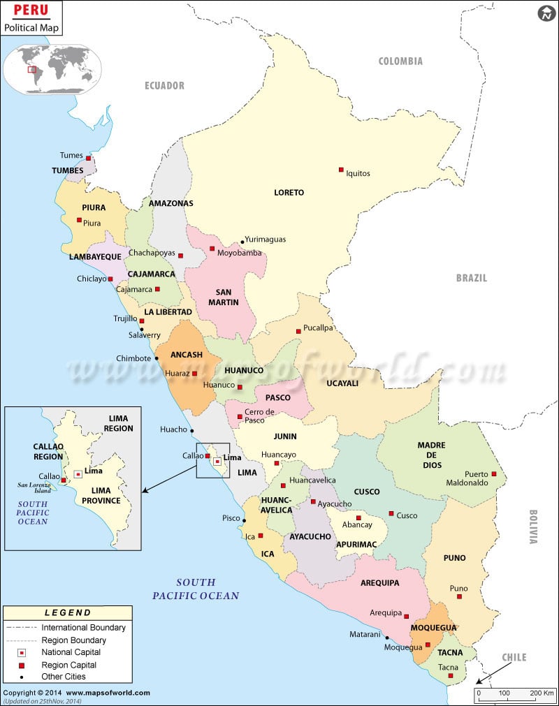
Peru political map is useful to students and discerning travelers. The map features the country’s capital, the administrative departments and their capitals. The political map of Peru also features the bordering countries namely Bolivia, Chile, Brazil, Ecuador and Colombia. Peru borders with Pacific Ocean on the western side. The red dot on the Peru map denotes the capital of Peru, Lima.
Peru, the Country
The geographical coordinates of Peru are 10° South latitude and 76° West longitude respectively. Peru shares its borders with Ecuador, Brazil, Bolivia, Chile and Colombia, which is shown in the map of Peru. 1,285,220 square kilometers is the total area of the country. Of the total area, the area covered by land is 1.28 million square kilometers and the remaining 5,220 square kilometers is covered by water bodies. 2,414 kilometers make up the coastline of the country and is marked with a blue line on the printable map of Peru.
Capital of Peru
Lima, situated at an altitude of 107 meters above sea level, is the capital of Peru. The capital is pointed with a red dot on the online political map of Peru. The latitudinal and longitudinal extent of the city is 12° 3’South and 77° 2′ 60″ West respectively.
The neighboring cities of Lima are Coronel, Poligono, La Victoria, Menacho, Monserrate and Chacra Colorada. The city’s airports are the main gateways to the city. They are Jorge Chavez International, Collique and Las Palmas.
Administrative Departments and their Capitals
The administrative departments of the country are distinctly colored on the Peru map so that they are easily differentiated. The administrative departments and their capitals are listed below:
|
|
| Region | Population | Area(km.²) | Area(mi.²) | Capital |
|---|---|---|---|---|
| Amazonas | 375,993 | 39,249 | 15,154 | Chachapoyas |
| Ancash | 1,063,459 | 35,826 | 13,832 | Huaraz |
| Apurimac | 404,190 | 20,896 | 8,068 | Abancay |
| Arequipa | 1,152,303 | 63,344 | 24,457 | Arequipa |
| Ayacucho | 612,489 | 43,815 | 16,917 | Ayacucho |
| Cajamarca | 1,387,809 | 33,248 | 12,837 | Cajamarca |
| Callao | 876,877 | 147 | 57 | Callao |
| Cusco | 1,171,403 | 71,892 | 27,758 | Cusco |
| Huancavelica | 454,797 | 22,131 | 8,545 | Huancavelica |
| Huanuco | 762,223 | 36,887 | 14,242 | Huanuco |
| Ica | 711,932 | 21,328 | 8,235 | Ica |
| Junin | 1,225,474 | 44,410 | 17,147 | Huancayo |
| La Libertad | 1,617,050 | 25,515 | 9,851 | Trujillo |
| Lambayeque | 1,112,868 | 14,213 | 5,488 | Chiclayo |
| Lima [Province] | 7,605,742 | 2,665 | 1,029 | Lima |
| Lima | 839,469 | 32,137 | 12,408 | Huacho |
| Loreto | 891,732 | 368,852 | 142,415 | Iquitos |
| Madre de Dios | 109,555 | 85,183 | 32,889 | Puerto Maldonado |
| Moquegua | 161,533 | 15,734 | 6,075 | Moquegua |
| Pasco | 280,449 | 25,320 | 9,776 | Cerro de Pasco |
| Piura | 1,676,315 | 35,891 | 13,858 | Piura |
| Puno | 1,268,441 | 70,003 | 27,028 | Puno |
| San Martin | 728,808 | 51,253 | 19,789 | Moyobamba |
| Tacna | 288,781 | 16,076 | 6,207 | Tacna |
| Tumbes | 200,306 | 4,669 | 1,803 | Tumbes |
| Ucayali | 432,159 | 102,411 | 39,541 | Pucallpa |
| 26 divisions | 27,412,157 | 1,283,092 | 495,404 |

