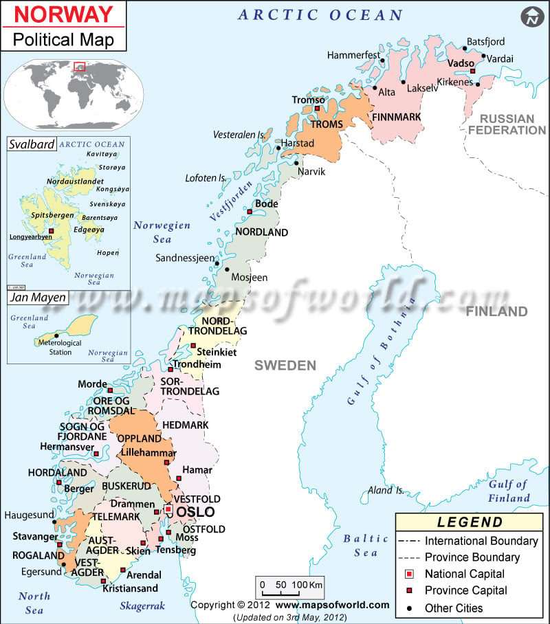
In the Norway political map, features like international and domestic boundaries, capital, and administrative divisions have been indicated clearly. The total area covered by the country is 323, 802 square kilometers. There are 1270 square kilometers of irrigated land in the country as per the report of the year 2003. Nynorsk Norwegian and Bokmal Norwegian are the official languages of the country.
Norway is a European country, located in the northern part of the continent. The country is officially known as the Kingdom of Norway. The geographic coordinates of Norway are 62º North latitude and 10º East longitude. The population of the country as per the estimate of 2022 is 5.6 million. In the political map of Norway, the provinces and their capitals, major cities, national capital, the international and domestic boundaries have been indicated using respective symbols.
Norway Capital
The capital of Norway is Oslo. The national capital has been highlighted in the political Norway map by a red square box having a black border. Oslo is the seat of the national Norway Government. The capital city is economically very strong. There are numerous places of tourist attractions in the city. Oslo is also a major maritime center of Europe. The city is served by four airports, which are Gardermoen, Kjeller, Torp, and Rygee. The most important railway station in the city is Oslo Sentralstasjon. The geographic coordinates of Oslo are 59º55′ North latitude and 10º45′ East longitude. The city lies at an altitude of 42 feet. Some of the cities located near Oslo are:
- Vika
- Ulleval Haveby
- Toyen
- Ekeberg
- Kongshamn
- Toyen
Norway Province Capitals
Norway has been divided into 19 counties. The capitals of the counties of Norway have been represented in the printable political map of Norway by white square boxes. The Norway counties are
|
|
The capitals of Norway counties indicated in the political printable map of Norway are Kristiansand, Arendal, Skien, Tensherg, Moss, Berger, Hamar, Lillehammer, Hermansver, Morde, Trondheim, Steinkiet, Bode, Trornso, and Vadso.
Norway Boundaries
The international boundaries of the country are marked on the political map of Norway by black lines. The country is positioned in the western part of the Scandinavian Peninsula. The bordering countries of Norway are Sweden, Finland, and Russian Federation. The Arctic Ocean is indicated in the northern part of the country. The North Sea and the Norwegian Sea are the water bodies bordering Norway.
Norway Cities
Some of the important cities of Norway have been pointed out on the map with black dots. Some of the indicated cities in the map of Norway are Egersund, Havdanger, Haugesund, Floro, Mosjeen, Sandnessjeen, Moi Rana, Narvik, Harstad, Alta and Vardai.
Neighbouring Countries of Norway: Russia, Finland & Sweden.
Counties of Norway |
||||
| County | Population | Area(km.²) | Area(mi.²) | Capital |
|---|---|---|---|---|
| Akershus | 476,440 | 4,917 | 1,898 | Oslo |
| Aust-Agder | 102,848 | 9,212 | 3,557 | Arendal |
| Buskerud | 239,591 | 14,927 | 5,763 | Drammen |
| Finnmark | 73,936 | 48,637 | 18,779 | Vadso |
| Hedmark | 187,878 | 27,388 | 10,575 | Hamar |
| Hordaland | 437,766 | 15,449 | 5,965 | Bergen |
| More og Romsdal | 243,888 | 15,104 | 5,832 | Molde |
| Nordland | 237,561 | 38,463 | 14,851 | Bodo |
| Nord-Trøndelag | 127,444 | 22,396 | 8,647 | Steinkjer |
| Oppland | 183,302 | 25,191 | 9,726 | Lillehammer |
| Oslo | 512,093 | 454 | 175 | Oslo |
| Ostfold | 252,520 | 4,183 | 1,615 | Moss, Sarpsborg |
| Rogaland | 380,913 | 9,326 | 3,601 | Stavanger |
| Sogn og Fjordane | 107,261 | 18,619 | 7,189 | Hermansverk |
| Sor-Trondelag | 266,098 | 18,832 | 7,271 | Trondheim |
| Telemark | 165,732 | 15,315 | 5,913 | Skien |
| Troms | 151,646 | 25,848 | 9,980 | Tromso |
| Vest-Agder | 157,697 | 7,281 | 2,811 | Kristiansand |
| Vestfold | 216,333 | 2,216 | 856 | Tonsberg |
| 19 counties | 4,520,947 | 323,758 | 125,004 | |

